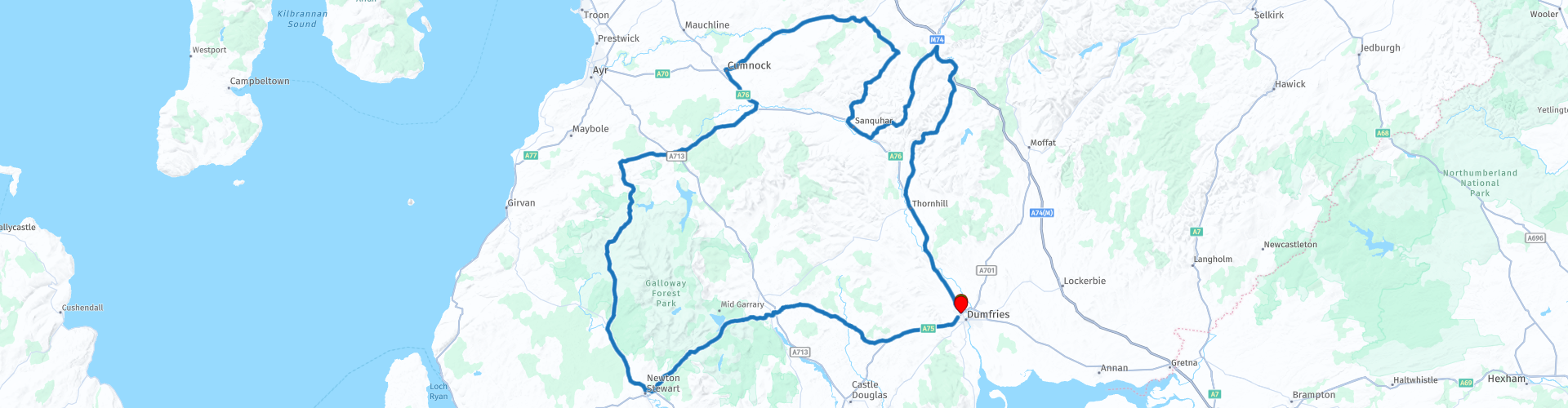
Round trip from Dumfries through the Southern Uplands of Lanarkshire and back via the Galloway Forest Park

This route was brought to you by:
RouteXpert Nick Carthew - (MRA Master)
Last edit: 15-07-2021
 Route Summary
  Share this route


Animation

Verdict


Duration
7h 17m

Mode of travel
Car or motorcycle

Distance
291.83 km

Countries

 RouteXpert Review
 You will pass areas of historic industrial mine workings left over from the coal and lead industries, most of it now being taken over by nature but there are still clues to be seen. One of the villages is even called Leadhill and the nearby hill is named Mine Hill. There is a visitor centre in the village of Wanlockhead where you can stop for a coffee and learn some of the mining history.
There are also the remains of gold workings dating to the 16th century. The workings survive primarily as a series of deep channels, known as gold scours, cut into the hillside above the Shortcleuch Water. The site is associated with the Scottish monarchy; James IV and V both granted rights to mine the area and the gold produced was a significant resource for the Crown. Much of the gold coinage of James V and Mary Queen of Scots was minted from gold from this district.
From lead mining to coal mining, the route now travels past old mine workings of the Carmacoup Colliery as it heads towards the Galloway Forest Park. When you reach the town of Dalmellington RP 21, you have a choice to turn left and pick up the route again at RP 36. This will shorten the route by approximately 40 miles (64 km) 75 minutes for those that just want an A.M. or P.M. ride.
The Galloway Forest Park is Britain’s largest forest park. As well as catering for recreation, the park includes economically valuable woodland, producing 500,000 tons of timber per year. This is also Scotland’s first Dark Sky Park – one of the best places to stargaze in Europe! The forestry work is clear to see with areas of mature trees, freshly felled and newly planted saplings. You will also travel across vast areas of open moorland where the road surface can be a little bumpy but the scenery makes up for it.
The route heads east back towards Dumfries on the A712 at Newton Stewart. This is another great road that twists and turns and after crossing over more moorland, gradually becomes more rural countryside.
At RP 30 is the Glen of the Bar. A historic viewpoint at the head of a long tree-clad gully. Numerous animal bones have been found at the end of the gully, prompting historians to suggest that early peoples of the area herded wild animals into the steep sided ravine, and then hurled stones and spears at them to kill them.
The Grey Mare's Tail Waterfall is about 2 km further on and a 100 m walk from the roadside will get you to the foot of the falls for a photo. One of Scotland's finest waterfalls, with a magnificent 60m cascade of pure water.
You will then arrive at Clatteringshaws Reservoir and Visitor Centre where there is a cafe and great views across the waters of the reservoir. The A712 takes you over the River Urr an onto the village of Crocketford to join the A75 which is just 10 minutes back to the start point.


 Usage
Usage Want to download this route?
You can download the route for free without MyRoute-app account. To do so, open the route and click 'save as'. Want to edit this route?
No problem, start by opening the route. Follow the tutorial and create your personal MyRoute-app account. After registration, your trial starts automatically.  Disclaimer
Use of this GPS route is at your own expense and risk. The route has been carefully composed and checked by a MyRoute-app accredited RouteXpert for use on TomTom, Garmin and MyRoute-app Navigation.
Changes may nevertheless have occurred due to changed circumstances, road diversions or seasonal closures. We therefore recommend checking each route before use.
Preferably use the route track in your navigation system. More information about the use of MyRoute-app can be found on the website under 'Community' or 'Academy'.