Round tour from Knaphill Via South Downs National Park

This route was brought to you by:
RouteXpert Paul Taylor
Last edit: 04-11-2025
 Route Summary
 I have awarded this route with 4 stars because the roads, attractions and the scenery are all very good.
 Share this route


Animation

Verdict


Duration
7h 5m

Mode of travel
Car or motorcycle

Distance
266.55 km

Countries

 RouteXpert Review
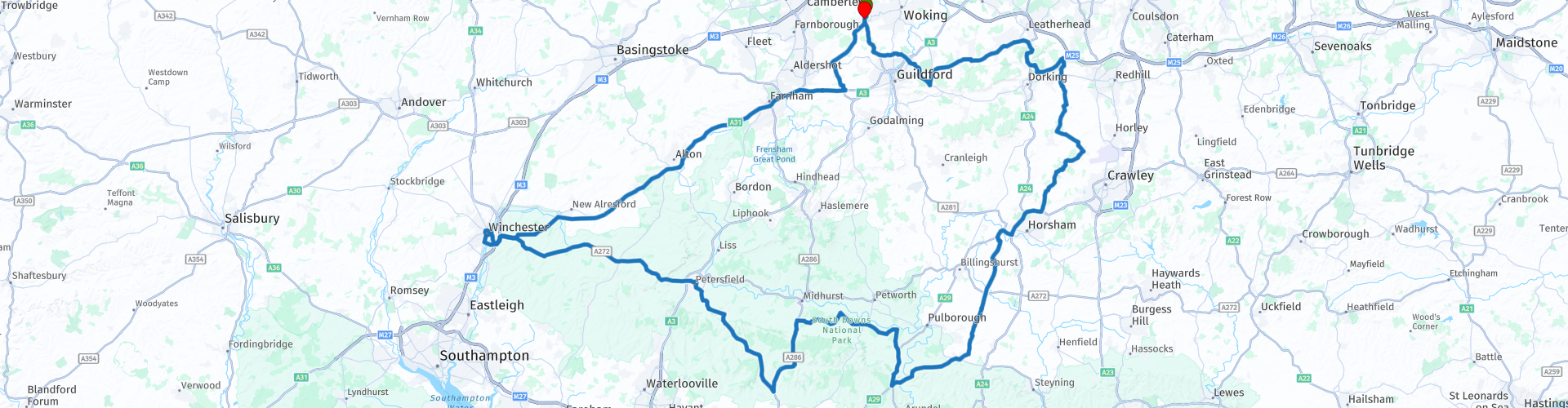
 With a quick scoot around the 10th century town of Guildford and getting onto the A322 you soon arrive within the Merrow Downs, these boasts some spectacular views and great walks and forms part of the Surrey Hills. After a stop at Newlands Corner cafe for breakfast, the first of four café stops, you will continue onwards to the A246, which has woodlands to the left, thick green trees lining the road and small rolling hills in the beautiful Surrey countryside, before you know it you arrive at the famous Ryka’s Café at the foot of Box Hill, here you can stop for refreshments. Within 5 minutes of leaving Ryka’s you are riding up the twisting hilly road up to Boxhill, at nearly 735 feet above sea level you are greeted with more fantastic scenic views, overlooking the amazing rolling hills you have just ridden, here you have just enough time for a quick photo opportunity, with or without the bike is the hardest decision you will have to make today!
Swiftly moving on you get onto the B2032 and cross over the River Mole; this is a tributary of the river Thames and flows through surrey for 50 miles to the Thames, continuing on the B2032 you head towards the beautiful Lowfield Heath Windmill, a grade II listed post mill which was built in 1737/8. Unfortunately, in the early 1880’s it was superseded by steam power and so soon fell into dis-repair. It took a staggering 13 years of hard work and great skill to dismantle, repair and re-erect the Mill to its former glory that it can be seen in today. Here is one for the avid plane spotter, a very small detour from here and you are at Gatwick airport fence watching the planes, but because of the lush thick green foliage and peace and tranquillity of your current surroundings you wouldn’t believe that it was so close.
Soon after leaving Lowfield Heath Windmill, you cross over into the county of West Sussex and over the River Arun at 37 miles long, it is the longest river entirely in Sussex, you will also cross this once again just before arriving at Whiteways café where you have time to take on some lunch and refreshment, do remember that this is now an all vehicles pay for carpark.
After leaving Whiteway’s café heading across to the A286 you experience about 6 miles of some nice twisty roads with more great views. You also pass close by the famous Goodword park horse racing track where horse racing has taken place since 1802. Once on the B2124 you have hills to the right with some up to 770 feet above sea level this is when the road begins meandering downwards. Turning on to the B2146 you pass over into the county of Hampshire and into the ancient market town of Petersfield. This was built as a Norman “new town” at the end of the 11th century, once through Petersfield the final café stop is at Loomies Moto cafe where you can take on more refreshments if you so wish, this is a motorcycle themed cafe in a great bit of countryside with a great atmosphere for all bikers.
Taking the A272 and a short ride from Loomies you soon enter the lovely city of Winchester, on the edge of England's South Downs National Park, whose history can be trace back to the 1st century, this soon became an important settlement centre for the British Belgae tribe. The houses are predominantly of Medieval, Elizabethan and Jacobean era they line the streets with the Chesil Rectory being one of the oldest dated buildings there is in Winchester and dates back to between 1425-1450, and is one of Winchester's best preserved Medieval buildings. You also have Winchester Cathedral this was built from 1079 to 1532 as it currently stands and is among the largest of its kind in Northern Europe, it receives nearly 400,000 visitors in a single year and a lot of these come to see the tomb of Jane Austen, one of the greatest English novelists of all times who was buried here in 1871 at just aged 41. There is limited free motorcycle parking with Friarsgate undercover parking or St Peters a bit further away from the Cathedral.
After leaving the city of Winchester via the A31, a fast route is taken back of approximately 22miles.


 Links
Links  Usage
Usage Want to download this route?
You can download the route for free without MyRoute-app account. To do so, open the route and click 'save as'. Want to edit this route?
No problem, start by opening the route. Follow the tutorial and create your personal MyRoute-app account. After registration, your trial starts automatically.  Disclaimer
Use of this GPS route is at your own expense and risk. The route has been carefully composed and checked by a MyRoute-app accredited RouteXpert for use on TomTom, Garmin and MyRoute-app Navigation.
Changes may nevertheless have occurred due to changed circumstances, road diversions or seasonal closures. We therefore recommend checking each route before use.
Preferably use the route track in your navigation system. More information about the use of MyRoute-app can be found on the website under 'Community' or 'Academy'.

South East
About this region
The points of the compass are an evenly spaced set of horizontal directions (or azimuths) used in navigation and geography. A compass rose is primarily composed of four cardinal directions—north, east, south, and west—each separated by 90 degrees, and secondarily divided by four ordinal (intercardinal) directions—northeast, southeast, southwest, and northwest—each located halfway between two cardinal directions. Some disciplines such as meteorology and navigation further divide the compass with additional azimuths. Within European tradition, a fully defined compass has 32 'points' (and any finer subdivisions are described in fractions of points).Compass points are valuable in that they allow a user to refer to a specific azimuth in a colloquial fashion, without having to compute or remember degrees.
Read more on Wikipedia
View region
 Statistics
  27
27Amount of RX reviews (South East)
 23719
23719Amount of visitors (South East)
 2270
2270Amount of downloads (South East)
 Route Collections in this region
 8 beautiful routes through England
"8 beautiful routes through England"
You may have seen one of these routes pass by. Eight routes have been driven and made in 2018.The routes are part of a 9-day trip through England. You drive through landscapes that are varied and beautiful. You can see beautiful rolling hilly vistas.
The main roads are of reasonable to good quality, but you also drive on roads that are less maintained and there may be some gravel on the roads here and there.
In general, they are beautiful routes through a beautiful country. The routes are connecting and turn left around London. The start and end points of the routes are Hull.
The collection contains the following routes;
Day 1 from Hull to Ashbourne (224 km)
Day 2 from Ashbourne to Birdlip (245 km)
Day 3 from Birdlip to Feldbridge (295 km)
Day 4 from Feldbridge to Whitstable (250 km)
Day 5 from Whitstable to Colchester (227 km)
Day 6 from Colchester to Hinckley (233 km)
Day 7 Tour and visit Triumph Factory and National Motorcycle Museum (77 km)
Day 8 from Hinckley to Hull (262 km)
All routes have been checked and leveled for Tomtom, Garmin and MyRoute-App Navigation. The routes follow the original route as they were made at the time.
Have fun driving one of these routes. Enjoy all the beauty that England has to offer, such as; The Clumberpark, Bolsover Castle, The Seven Sisters, The White Ciffs of Dover. Of course, a visit to the Triuph factory and the National Motorcycle Museum is also highly recommended.
View Route Collection
A collection of routes covering East England including Hull Scarborough Newmarket Colchester Orpington and Folkestone
East England has a host of great roads to travel and many historical sites to visit.
The picture above shows the North York Moors National Park in all of it's glory with the heather in full bloom. This collection of routes covers as far north as Lindisfarne and as far south as Folkestone, they all travel through varied landscapes from high moorland to the level fens and everything in between. There is something for everyone in this collection. There is also a mini 2 day tour down the east coast from Hull to the Eurotunnel for those that want to enjoy the journey south before heading into Europe, this of course can be joined from anywhere along the way.
As with all MyRoute-app RouteXpert routes, these have been made equal for MRA Navigation, TomTom and Garmin devices meaning that whatever GPS satnav you use, you and all of your travelling companions are guaranteed to follow these routes precisely. Enjoy.
View Route Collection