Arctic Coast Way Day 1 Hvammstangi Blonduos

This route was brought to you by:
RouteXpert René Plücken (MRA Master)
Last edit: 16-03-2021
 Route Summary
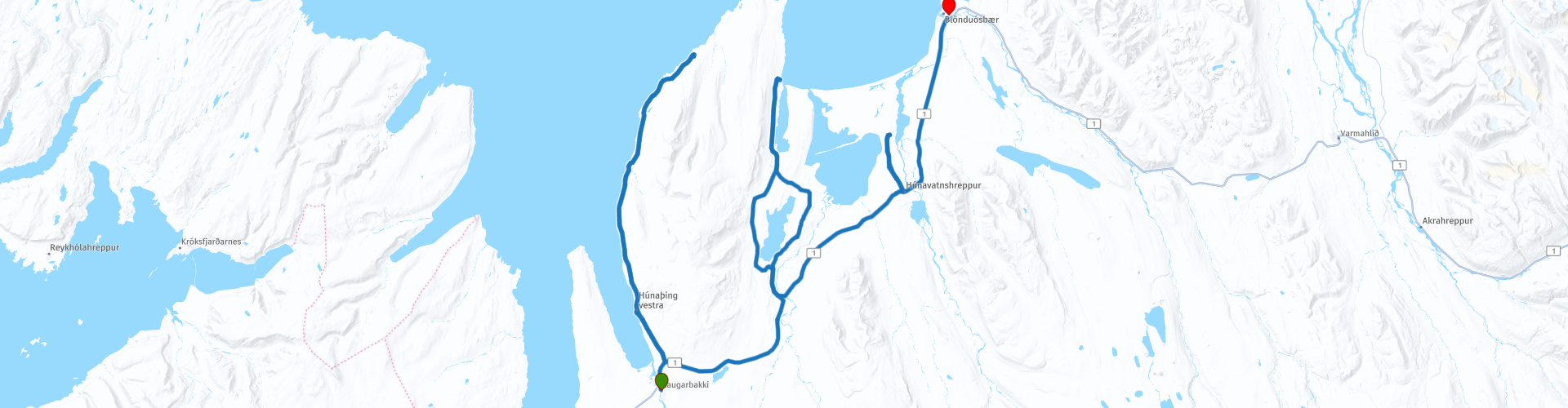
 The Arctic Coast Way starts in Hvammstangi in the North West and ends in Bakkafjörður in the North East. This approximately 900 kilometer long “Off the Beaten track” route passes through rugged North Iceland and follows the beautiful Fjord coast.
Driving the Arctic Coast Way is different from what you might be used to. It is a true off the beaten track route that takes you through beautiful remote landscapes. This means leaving civilization behind in the spirit of adventure and exploration.
We drive large parts on unpaved roads (about 1/3 part), sometimes with large holes, so this route is only suitable for Adventure or Off Road motorcycles or for cars with 4x4 drive. Drive slowly to enjoy the magical surroundings but because of the sheep and birds that can walk on the road.
The route runs close to the Arctic Circle and many stops are planned along the way to visit Iceland's many highlights. A number of examples are the many waterfalls, glaciers, fishing villages and fjords. In some cases you have to take a walk (hike), these can influence the planning of the rides, so keep that in mind. Due to the slower speed on the unpaved roads and the sights en route, the routes have been kept short.
Enjoy the freedom along the way, but respect nature and keep in mind that wild camping is prohibited, you are only allowed to camp on campsites or with the permission of the owner on his private property. All villages along the route have camping options. All campsites have rubbish bins and sanitary facilities. Do not drive off-road, but stay on the designated roads. Off-road driving is prohibited, with heavy fines.
This is the first day of the six day Arctic Coast Way Roadtrip which I rate with 5 ***** Stars for its beautiful nature, beautiful places to visit and the adventurous aspect.
Enjoy!
 Share this route


Animation

Verdict


Duration
9h 39m

Mode of travel
Car or motorcycle

Distance
131.96 km

Countries

 RouteXpert Review
 In Hvammstangi you can visit the Bardúsa shopping museum (Bardúsa verslunarminjasafn) at RP2, here you will find remains of this old merchant's shop from the beginning of the 20th century. Good quality handicrafts from the area are also sold. At RP4 you can visit the Icelandic Seal Information Center, which not only provides information about the seals and birds, but also generic information for tourists.
Within walking distance of the museum is a supermarket (RP5) where you can buy the necessary provisions for the road. Keep in mind that for the next few days you will be driving through mostly uninhabited areas and so there are not many opportunities to buy food and drinks.
And now we start with the Arctic Coast Way, the first day we drive over the Vatnsnes peninsula. There are several mountains on the peninsula, of which Þrælsfell (906 meters) is the highest. The only place of significance is the fishing town of Hvammstangi. At the northern tip is the abandoned settlement of Hindisvík and the nearby seal bay. The Vatnsnesvegur (Vatnsnesweg) with road number 711 runs almost all the way around the Vatnsnes peninsula and connects to the Hringvegur which runs in a large circle all over Iceland.
The first stop is planned at Ánastaðarstapi (RP7), after a short walk you will reach the sharp rock formation in the sea. You can walk even further to Grímsá (1 to 2 hours).
After about 1 kilometer drive, you will stop short at Skardsviti Lighthouse (RP8) a small secluded lighthouse secluded that is easily accessible. In good weather, the view over the fjord is breathtaking, so definitely worth a look.
After about 3 miles (5 km) you can stop briefly at RP9 to see a typical Icelandic enclosure where the Leader sheep are kept. At RP10 you can stop for a cup of coffee.
The next longer stop is planned at Seal Beach (RP11). Stop here to admire the view and with a bit of luck you can spot some more seals in the wild. Lunch is planned in restaurant Geitafell (RP13). Enjoy fresh Icelandic Seafood meals in a pure Icelandic natural environment. At Geitafell you can also take long and short walks, pet the horses, visit the tower exhibition and see some restored ruins.
After lunch, drive to Hvítserkur (RP14), a rock in the sea at the northern tip of the Vatnsnes peninsula. This rock looks a bit like a drinking dragon.
Hvítserkur is about 15 meters high. The base is reinforced with concrete, because otherwise the waves of the Atlantic Ocean would have caused the rock to collapse long ago. The name means "white shirt", because of the many bird droppings on the rock, including from fulmars. According to tradition, Hvítserkur was said to be a troll who pelted the Þingeyrar monastery with stones and did not notice the rising sun, after which he petrified.
Near Hvítserkur there is the possibility to have a drink and eat at Farfuglaheimili Hostel and Café (RP15). The next stop at RP16 is the Borgarvirki (Citadel), a curious batch of rocks and 10 to 15 meter high basalt columns, on which lie the remains of a pre-medieval fortress. It is the only fort in the country.
After about 45 minutes driving we arrive at Þingeyrakirkja (RP17), this is one of the most beautiful churches in Iceland, laden with stones and richly equipped with expensive treasures. Ásgeir Einarsson, a farmer and member of the Althingi, had the church built and hired Sverir Runólfsson, one of the most talented stonemasons in the country at the time. The church was dedicated for use on September 9, 1877.
The end of the ride is in Blönduós, where we spend the night at Camp Site Gladheimat, where you can also rent a cottage. Shortly before the campink you can visit the Heimilisiðnaðarsafnið textile museum, turn left at RP18 for this. Here a unique collection of homemade wool and textile items is displayed. It also exhibits beautiful Icelandic national costumes and artistic embroidery, along with many of the tools and equipment used to produce them. It is the only one of its kind in Iceland and was founded by the Women's Union in East Húnavatnssýsla. Today it is housed in a beautiful new building and the exhibitions are easily accessible to visitors.


 Links
Links  Usage
Usage Want to download this route?
You can download the route for free without MyRoute-app account. To do so, open the route and click 'save as'. Want to edit this route?
No problem, start by opening the route. Follow the tutorial and create your personal MyRoute-app account. After registration, your trial starts automatically.  Disclaimer
Use of this GPS route is at your own expense and risk. The route has been carefully composed and checked by a MyRoute-app accredited RouteXpert for use on TomTom, Garmin and MyRoute-app Navigation.
Changes may nevertheless have occurred due to changed circumstances, road diversions or seasonal closures. We therefore recommend checking each route before use.
Preferably use the route track in your navigation system. More information about the use of MyRoute-app can be found on the website under 'Community' or 'Academy'.