Sauris und Naturpark Weissensee Rundtour

This route was brought to you by:
RouteXpert Chantal HV
Last edit: 12-04-2020
 Route Summary
 Spaghetti curves for advanced
Bella ragazza - not only Italian women have beautiful curves ...
250 km of never-ending curves - on this tour, not only a good cappuccino will make your heart beat faster ...
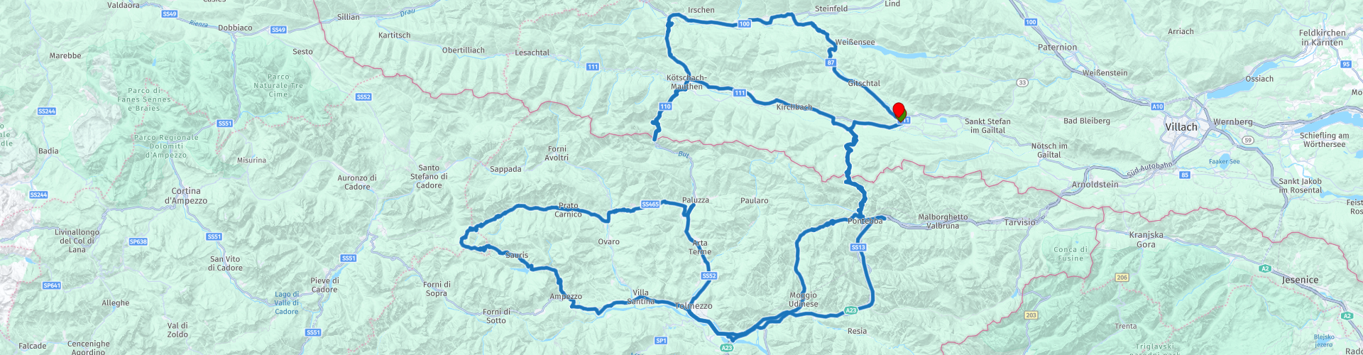
Gailtal - Hermagor - Nassfeld - Pontebba - Val d'Aupa - Dordolla - Moggio - Toledo - Ampezzo - Sauris - Prato - Comeglians - Paluzza - Timau - Plöckenpass - Kötschach- Mauthen - Gailberg saddle - Oberdrauburg - Greifenburg - Kreuzbergpass - Hermagor
 Share this route


Animation

Verdict


Duration
5h 18m

Mode of travel
Car or motorcycle

Distance
250.95 km

Countries


 RouteXpert Review
 The route has been carefully compiled for use in TomTom, Garmin and MyRoute app navigation.
The tour falls under the category "medium" (Austria uses "easy, medium and hard"). Sufficient stops on the way with a nice view or to eat or drink. This tour gets 5 stars.
Spaghetti curves ...
From Hermagor in the direction of Tröpolach it goes on the Nassfeld - Passo Pramollo, 1.552m (RP 2), past Carinthia's largest ski resort after Pontebba in Italy. Continue through the beautiful Val d'Aupa towards Moggio and Tolmezzo. Once you have passed the rather unclear roundabout in Tolmezzo, head towards Ampezzo, where you turn right to Sauris. Now it goes on the very narrow and winding road, with partly unlit tunnels, along the Lumischlucht up to Sauris at 1400 m (highest village in Friuli) with very nice restaurants.
Attention: between RP 8 and 9 Garmin and TomTom do not match, route point skipped. Just keep left.
Coffee break we make at Albergo Morgenleit (RP 10).
Continue to the pass via the Sella di Razzo -Razzosattel (RP 12) and at the end of the pass road turn right towards Prato and Comeglians to Paluzza. After a stop at Albergo Pace Alpina (RP 16), the route continues towards Timau via the well-developed Plöcken Pass (RP 19) at 1,360 m to Kötschach-Mauthen. Direction Greifenburg-Weissensee and over the Kreuzbergpass 1.077m (RP22) it goes back to Hermagor.
** The Kreuzberg Pass or Passo di Monte Croce Comelico is a 1636 meter high mountain pass on the border of the Italian provinces of South Tyrol and Belluno. The pass is located in the Dolomites, not far from the Drei Zinnen.


 Links
Links  Usage
Usage Want to download this route?
You can download the route for free without MyRoute-app account. To do so, open the route and click 'save as'. Want to edit this route?
No problem, start by opening the route. Follow the tutorial and create your personal MyRoute-app account. After registration, your trial starts automatically.  Disclaimer
Use of this GPS route is at your own expense and risk. The route has been carefully composed and checked by a MyRoute-app accredited RouteXpert for use on TomTom, Garmin and MyRoute-app Navigation.
Changes may nevertheless have occurred due to changed circumstances, road diversions or seasonal closures. We therefore recommend checking each route before use.
Preferably use the route track in your navigation system. More information about the use of MyRoute-app can be found on the website under 'Community' or 'Academy'.