TTT 2014 05 Den Dungen Zeeland

This route was brought to you by:
RouteXpert Hans van de Ven (Mr.MRA)
Last edit: 15-05-2021
 Route Summary
 The 173 ANWB Promoter TankTasTocht (TTT) were scanned by Henry ten Dam and signed by Leon Stolk in Mapsource and later placed as a Track in a .gpx file. These are made available through the MrGPS website with the approval of the ANWB Promoter so that everyone can enjoy them. The 1st TTT is from 1992, so the route may differ slightly from the original.
I have checked all route points and, where necessary, placed them neatly on the road. Also, if necessary, I have further spaced the start point and end point of the route to avoid navigating directly to the end point and I added the POI files from the start and end point just like a possible stopping point.
Finally, I made the route the same for TomTom, Garmin and MyRoute-app Navigation users.
Thanks to Henry, Leon, MrGPS and Promoter.
 Share this route


Animation

Verdict


Duration
3h 23m

Mode of travel
Car or motorcycle

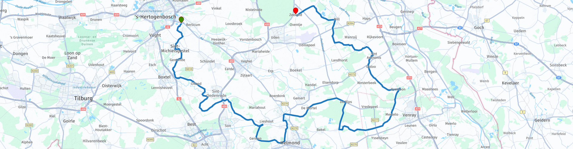
Distance
129.85 km

Countries

 RouteXpert Review
 After about 20 KM you will come across De Dommel for the first time, this is a stream and downstream a smaller river in the Kempen and the Meierij of 's-Hertogenbosch. It measures 120 kilometers, of which 35 kilometers on Belgian (Limburg) territory and 85 on Dutch (North Brabant) territory. In Sint-Oedenrode, 11 KM further you pass De Dommel for the 2nd time.
Along the Dommel several water mills have been preserved, both on Belgian and on Dutch territory. That is the case in Overpelt (Kleinmolen, Wedelse Molen, Bemvoortse Molen and Slagmolen), Valkenswaard (Venbergse Watermolen), Dommelen (Dommelse Watermolen), Waalre (Volmolen), Eindhoven (Genneper watermill) and Nederwetten (Hooidonkse watermill). This often concerns very old mills. The Wedelse Molen was already mentioned in 710.
Other water mills along the Dommel have disappeared in whole or in part, namely the Loondermolen between the Dommelse Watermolen and the Volmolen, the Stratumse Watermolen in Eindhoven and the Woenselse Watermolen in Woensel, the Wolfswinkelse Watermolen near Son, the Borchmolen in Sint-Oedenrode, the Kasterense Watermolen , two water mills in Boxtel and the water mill in Herlaar.
We drive on and after a small 40 KM you pass the Wilhelminakanaal in Lieshout and 15 KM further in Beek and Donk, the Wilhelminakanaal is a canal in the Dutch province of Noord-Brabant. It runs from the Zuid-Willemsvaart near Laarbeek to the Amer near Geertruidenberg and is 68 kilometers long. The part from Geertruidenberg to Dongen is navigable for ships up to 1350 tons. 1 KM further you will pass the Zuid Willemsvaart in Beek en Donk, this is a channel in the provinces of Dutch Limburg, Belgian Limburg and Noord-Brabant. It serves as the lateral channel of the Maas. Various other important waterways connect to it, including the other Kempian canals and the Wilhelminakanaal.
After all those waterways and Brabant landscapes it is time for coffee or lunch, you can do this at De Brabantse Kluis in Beek en Donk. After the stop, the Overloon direction continues and en route you pass the Defense or Peel Canal in Milheeze for the first time, this was dug in the Peel in 1939 - from Griendtsveen - as part of the Peel Raamstelling. The canal reaches the Raam, a river above Mill. It served as a drainage channel and anti-tank ditch, which quickly gave it the name Defense channel.
Once you have arrived in Overloon, you really have to go and eat an ice cream at Ice cream parlor Clevers, Clevers has been winning prizes for their ice cream since 1996, so that is enjoyed. Incidentally, Clevers has 8 businesses in Limburg, take a look at their website where they are. After enjoying your ice cream you can go back in time at the War Museum Overloon, this is a Dutch historical and educational museum that focuses primarily on the history of the Second World War in the Netherlands. We drive on and in Mill you pass the Defense Channel or Peel Canal for the 2nd time. Then in Langenboom you can pause for a moment at the Tornado garden, this is a monument in memory of a storm disaster (tornado) that ravaged Langenboom on 10 August 1925, a few minutes after 18.00.
We close this TTT in the town of Zeeland at Kwalitaria de Groot, where you can possibly have a cup of coffee.
Because I have driven large parts of this route myself, this route gets 4 stars.
Route details:
rp 24 - Coffee / Lunch stop at De Brabantse Kluis in Beek en Donk
rp 37 - Clevers Ice cream parlor in Overloon
rp 38 - Overloon War Museum
rp 49 - Tornado garden in Langeboom


 Links
Links  Usage
Usage Want to download this route?
You can download the route for free without MyRoute-app account. To do so, open the route and click 'save as'. Want to edit this route?
No problem, start by opening the route. Follow the tutorial and create your personal MyRoute-app account. After registration, your trial starts automatically.  Disclaimer
Use of this GPS route is at your own expense and risk. The route has been carefully composed and checked by a MyRoute-app accredited RouteXpert for use on TomTom, Garmin and MyRoute-app Navigation.
Changes may nevertheless have occurred due to changed circumstances, road diversions or seasonal closures. We therefore recommend checking each route before use.
Preferably use the route track in your navigation system. More information about the use of MyRoute-app can be found on the website under 'Community' or 'Academy'.