Rondrit Kampen Overijssel Weerribben Wieden

Diese Route wurde erstellt von:
RouteXpert Dick Schaap
Letzte Änderung: 16-08-2021
 Routenzusammenfassung
 Diese Route verläuft auf sehr guten (Deich-)Straßen und die Landschaft ist besonders schön. Ich bewerte diese Route mit 5 Sternen.
Start- und Endpunkt
MC Donalds
Zamboni-Straße 7
8263 CE Kampen NL
 Diese Route teilen


Animation

Urteil


Dauer
7h 8m

Reisemodus
Auto oder Motorrad

Entfernung
192.91 km

Länder

 RouteXpert-Überprüfung
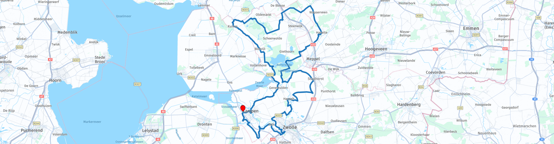
 Nach dem Start führt diese Route (von Jos van Ree) durch die Innenstadt von Kampen über den Burgwal und die IJsselkade zur Stadsbrug über die IJssel, um an IJsselmuiden vorbei und durch Genemuiden in die Polderlandschaft von Overijssel zu fahren. Kurz nach Genemuiden führt die Route am Naturschutzgebiet Wieden entlang zum Weerribben. Teils entlang der Grenze zum Flevopolder, über Deichstraßen, bis zum Dorf Kuinre. Dann über den Lindedijk, um dem Fluss Lende (friesisch: die Linde) zu folgen. Die Lende bildet die natürliche Grenze zwischen Overijssel und Friesland. Die Route folgt weiter dem Lindedijk, der in den Kloosterdijk übergeht, bis zum Nationalpark de Weerribben. Entlang und durch die Weerribben nach Willemsoord und Fredriksoord. Zwei Dörfer mit einer bemerkenswerten Kolonialgeschichte. Dann eine Strecke durch Drenthe, Richtung Havelte, entlang des Havelterbergs mit ua den größten Dolmen der Niederlande. Nach der Stadt Nijeveen mit ihrer speziellen Mühle „De Sterrenberg“ geht die Route in Overijssel weiter. Dort wird die Belterwijde im Naturschutzgebiet De Wieden überquert. Zusammen mit der Beulakerwijde bildet die Belterwijde einen riesigen Veenplas. Die Route führt dann durch die Bandbebauung der Dörfer Staphorst und Rouveen. Auch diese Dörfer zeichnen sich durch eine besondere Geschichte und Tradition aus. Nach Rouveen kommt wieder das Zwarte Water in Sicht. Es folgt die Überquerung und entlang des Zwarte Water in Richtung Zwolle. Nach Norden wird Zwolle passiert, danach führt die Route durch eine sehr schöne Landschaft zur IJsselbrug. Nach der IJsselbrug folgt die Route den Wendungen der IJssel über den Zalkerdijk bis zur Stadt De Zande. Nach De Zande über Kamperveen zurück nach Kampen mit einer weiteren Überquerung des Reevediep über die Nieuwendijk-Brücke.
Die wichtigsten Details dieser Route in der richtigen Reihenfolge.
Stadt Kampen
Kampen ist eine alte Hansestadt, gelegen am Unterlauf der IJssel, nahe der Mündung des IJsselmeers und des Keteldiep. Die Stadt liegt größtenteils auf einer Flussinsel und ist nur über (bürgerliche) Kunstwerke zu erreichen. Die Geschichte von Kampen geht zurück bis um 1150. Damals standen an der Stelle, an der sich das heutige Kampen befindet, bereits Holzbauten, der Name Kampen wird jedoch erst 1227 in der Geschichte erwähnt. Es gibt jedoch noch eine Urkunde in der Gemeinde Archiv von Kampen, in dem Abel, König der Dänen und Slawen und Herzog von Jütland, den Ommelandvaardern ein Privileg gewährt, vom 24. September 1251. Kampen war zu dieser Zeit bereits eine bedeutende und mächtige Stadt ("das Rotterdam der Mittelalter") und verfügte über eine große Flotte von Koggenschiffen. Die Ommelandvaart wurde mit diesen Koggenschiffen gemacht: die Seereise um Dänemark herum zur Ostsee.
Stadt Genemuiden
1275 erhielt Genemuiden von Jan van Nassau die Stadtrechte. Damals hieß der Ort 'Genemuden', später kommt auch die Schreibweise 'Gelemuiden' vor. Bischof Jan van Arkel gab der Stadt das Recht, gegen eine jährliche Lieferung von sechzig Pfund Wachs für die Kerzenherstellung über das Zwarte Water zu fahren. 1382 erwarben sie das Recht, drei Jahrmärkte abzuhalten. Der Ort wurde reich und baute ein Rathaus. Genemuiden wurde bekannt für den Eilanbau und das Handwerk der Stuhlangelegenheiten.
das jäten
Ein Seen- und Feuchtgebiet Natura 2000, mit De Belterwijde und Beulakerwijde (auch Belterwiede und Beulakerwiede genannt) sind zwei große Torfseen Teil dieses Naturschutzgebietes.
Die Lende (friesisch: die Linde)
Zwischen dem See Het Wijde und dem Dorf Slijkenburg bildet er die natürliche Grenze zwischen Overijssel und Friesland. Die Quelle der Linde liegt in der Nähe von Tronde
Die Wetterrippen
Weerribben-Wieden, eines der speziellsten Gebiete der Niederlande und das größte Torfmoorgebiet Nordwesteuropas. Dank der menschlichen Hände von Torf- und Schilfstechern entstand eine einzigartige Landschaft voller Seen, Kanäle, Schilfgürtel, Sumpfwälder und Zittermoore. Eine Vergangenheit voller Torf, Torf und Schilf ergibt eine schöne Gegenwart. Atemberaubende Natur und endlose Wasserspiele.
Die Tjasker-Mühle
Ein Tjasker hat im Gegensatz zu 'normalen' Windmühlen keine Zahnräder. Auf der Welle, durch die die Messer ragen, befindet sich hinten eine Trommelmühle. Dies ist eine kleine Art von Mörtel mit einer Verkleidung um ihn herum. Windmühlenexperten sagen, dass die einzige Ähnlichkeit zwischen dem Tjasker und allen anderen Windmühlentypen der Besitz eines Segelkreuzes ist. Das Segelkreuz kann altholländisch oder Rahsegel sein. Es gibt zwei Arten von Tjaskern: den Paaltjasker und den Boktjasker. Beim Paaltjasker wird die Mühlenwelle von einer Stange getragen und beim Boktjasker liegt die Vorderseite der Mühle auf einem Holzbock. Der paaltjasker mahlt das Binnenwasser über die Schneckenschüssel zum Außenringgraben oder vom Außenringgraben zum Binnengewässer. Der Boktjasker mahlt das Wasser aus dem Binnengewässer über die Schneckenschüssel zum äußeren Ringgraben, der zum Außenwasser mündet. Nur der Boktjasker hat eine Kriechspur für das Kreuz der Segel im Wind. Der Stelzenbeschichter wird mittels einer Kette in den Wind gezogen.
Vor allem in Naturschutzgebieten werden solche Mühlen eingesetzt, um Austrocknung zu verhindern.
Willemsoord und Frederiksoord (und auch Wilhelminaoord)
Willemsoord (1820), Frederiksoord (1818) und Wilhelminaoord (1821) ursprünglich drei freie Kolonien, gegründet von der Society of Benevolence, um benachteiligten Familien aus dem Westen unseres Landes die Möglichkeit zu bieten, ein neues Leben aufzubauen. Die Siedler erhielten ein Haus mit einem Hektar Land, für ihren Unterhalt wurde gesorgt, es gab medizinische Hilfe sowie religiöse und schulische Bildung. Dank des Beitrags einer großen Zahl einigermaßen wohlhabender Niederländer konnten die Lebensbedingungen dieser unteren Schichten erheblich verbessert werden. Das Haus Oranien interessierte sich sehr für die Pläne. Der Kronprinz von Oranien, später König Willem II., gab Willemsoord seinen Namen. Willem hat den Bau der Schule und des Lehrerhauses aus eigener Tasche bezahlt: gerade einmal 1400 Gulden für die Realisierung beider Gebäude.
Gürtelbreit
Genannt kurz Belter. Die Belter- und Beulakerwijde entstanden 1775, 1776 und 1825 durch Sturmfluten, die große Landstriche wegfegten. Diese Moorseen sind heute Teil des Nationalparks Weerribben-Wieden.
Havelteberg
Der Havelterberg ist ein mit Heide bedeckter Hügel bei Havelte. Auf dem Berg verstreut finden Sie überraschend viele Überreste prähistorischer Besiedlung: Grabhügel, Urnenfelder und natürlich die berühmten Dolmen. Die Havelterberg-Dolmen sind riesig. Sie sind etwa 200 Meter voneinander entfernt. Der größte ist etwa 18 Meter lang und liegt direkt an einem sandigen Weg und Wanderweg. Die Dolmen stammen aus der Jungsteinzeit (vor 3400 - 2580 Jahren). Sie sind Gräber der 'Trichterbecherkultur'.
Getreidemühle der Sterrenberg
Es handelt sich um eine reetgedeckte, achteckige Gerüstmühle aus dem Jahr 1786, die ursprünglich aus Weener in Ostfriesland in Deutschland stammt und der Familie Sterrenberg gehört. In den 1970er Jahren an den heutigen Standort am Bürgermeister von Weimalaan überführt und dort restauriert. Diese Mühle ist die einzige Mühle in den Niederlanden mit einer Windrose auf der Haube zum automatischen Drehen. Die Blätter haben einen Flug von 23 Metern und sind selbstschwingend.
Staphorst und Rouveen
An der Hauptstraße, dem alten Rijksweg/Gemeenteweg, von Staphorst und Rouveen liegen mehr als tausend Bauernhöfe dicht beieinander. Traditionell hatte jeder Hof ein langgestrecktes Grundstück in der dahinter liegenden Landschaft. Nach dem örtlichen Erbrecht erhielten die Söhne bis 1970 einen gleichen Anteil am Grundstück, so dass die Grundstücke enger wurden und teilweise sogar direkt hintereinander Bauernhöfe gebaut wurden. Es war daher oft Tradition, dass die Kinder hinter dem elterlichen Hof einen Hof bauten. Viele der heutigen Gebäude wurden in der Zeit nach der verheerenden Flutkatastrophe von 1825 errichtet. Die Bandbebauung mit nicht weniger als 300 denkmalgeschützten Höfen gilt heute als geschütztes Dorfbild.
Auffallend an Staphorst und Rouveen sind die (hell)grünen Fensterläden in Kombination mit (hell)blauen Fensterbänken, Türen mit einem sogenannten Lebensbaum über der Haustür und die traditionelle Tracht, die von Jung bis Alt von Männern und Frauen getragen wurde . Kinder, die dauerhaft oder nur im Winter Trachten tragen, sind schon heute eine Seltenheit. Sie sehen darin keine erwachsenen Männer mehr, außer ein paar ältere Männer. Es gibt noch ziemlich viele erwachsene Frauen in traditioneller Tracht.
Seit 1937 ist in den Allgemeinen Ortsbestimmungen festgelegt, dass es verboten ist, "jemanden ohne deren Erlaubnis auf oder in der Nähe der Straße zu fotografieren".
Die nachtfreie Luke
Bis in die 1940er Jahre wurde die sogenannte nachtfreie Luke verwendet. Dies ermöglichte es einem Jungen, Zugang zu Haus und Bett eines Mädchens zu bekommen, um sich besser kennenzulernen. Diese Tradition war im 17. Jahrhundert in den Niederlanden weit verbreitet, wurde jedoch später zunehmend als sündhaft und unanständig bekämpft. Staphorst und Rouveen sind die letzten Orte, an denen zu Beginn des 20. Jahrhunderts noch Nachtsex stattfand.
1971 war Staphorst wegen eines Ausbruchs von Polio (Kinderlähmung) Weltnachrichten. Mehrere Anwohner wollten ihre Kinder aus religiösen Gründen nicht gegen dieses Virus impfen lassen. Sie fanden eine Impfung entgegen der göttlichen Vorsehung. Infolgedessen waren 39 Menschen (die meisten davon Kinder) mit dieser Krankheit infiziert. Fünf von ihnen starben, einige andere wurden behindert. Heute ist die Situation anders und die meisten Staphorster sind geimpft. Da jedoch etwa zwanzig Prozent noch nicht geimpft sind und es sich um eine Gruppe handelt, die in einer Gemeinde zusammenlebt, gelten dieser Ort sowie vergleichbare andere Orte in den Niederlanden als einziges europäisches Risikogebiet für die Weltgesundheitsorganisation .
Schwarzes Wasser
Het Zwarte Water ist ein 19 km langer Fluss in Overijssel. Der Fluss fließt von Zwolle zum Zwarte Meer am Noordoostpolder. Der Name hat nichts mit der Farbe Schwarz zu tun, sondern mit Schweiß, was Grenze bedeutet. Das Zwarte Wasser war von großer Bedeutung für die Entwicklung der Hansestadt Zwolle. Sie verband die Stadt mit dem Meer und den anderen Hansestädten.


 Links
Links  Nutzung
 Möchten Sie diese Route herunterladen?
Sie können die Route ohne MyRoute-App-Konto kostenlos herunterladen. Öffnen Sie dazu die Route und klicken Sie auf 'Speichern unter'. Möchten Sie diese Route bearbeiten?
Kein Problem, starten Sie mit dem Öffnen der Route. Folgen Sie dem Tutorial und erstellen Sie Ihr persönliches MyRoute-App-Konto. Nach der Registrierung startet Ihre Testversion automatisch.  Haftungsausschluss
Die Nutzung dieser GPS-Route erfolgt auf eigene Kosten und Gefahr. Die Route wurde sorgfältig von einem MyRoute-App akkreditierten RouteXpert für die Verwendung mit TomTom, Garmin und MyRoute-App Navigation zusammengestellt und geprüft.
Durch geänderte Umstände, Straßenumleitungen oder saisonale Sperren können sich dennoch Änderungen ergeben haben. Wir empfehlen daher, jede Route vor der Nutzung zu überprüfen.
Verwenden Sie vorzugsweise den Routentrack in Ihrem Navigationssystem. Mehr Informationen zu den Die Nutzung der MyRoute-App finden Sie auf der Website unter 'Community' oder 'Academy'.

Provinz Flevoland
Über diese Region
Flevoland ist die zwölfte und jüngste Provinz der Niederlande. Sie wurde am 1. Januar 1986 aus der Öffentlichen Körperschaft Südliche IJsselmeerpolder (Ost- und Südflevoland) und dem Nordwesten der Provinz Overijssel (Noordoostpolder) neu gebildet. Flevoland besteht fast ausschließlich aus Land, das erst im 20. Jahrhundert dem IJsselmeer abgewonnen wurde. Der Osten der Provinz ist landwirtschaftlich geprägt, der Westen entwickelte sich mit Almere zu einer Erweiterung des Einzugsgebiets von Amsterdam. Hauptstadt Flevolands ist Lelystad, für das ursprünglich der Name Flevostad vorgesehen war.
Lesen Sie mehr auf Wikipedia
Region anzeigen
 Statistik
  31
31Anzahl der RX-Bewertungen (Provinz Flevoland)
 41481
41481Anzahl der Besucher (Provinz Flevoland)
 4615
4615Anzahl der Downloads (Provinz Flevoland)
 Routensammlungen in dieser Region
 Die 10 schönsten Auto- und Motorradrouten in den Niederlanden
Diese 10 Routen in den Niederlanden wurden von einem MyRoute-App RouteXpert sorgfältig ausgewählt, geprüft und für TomTom, Garmin und MyRoute-App Navigation gleichgestellt. Die 10 schönsten Motorrad- und Autorouten in den Niederlanden sind immer eine Momentaufnahme und eine persönliche Meinung des Rezensenten. Das ändert nichts daran, dass jeder Liebhaber schöner Straßen und interessanter Sehenswürdigkeiten diese Strecken genießen wird.
Die zehn Routen verteilen sich auf 10 Provinzen, wir haben nur Flevoland und Südholland übersprungen. Interessante Routen finden sich auch in der MyRoute App RouteXpert Bibliothek, wir wollen aber trotzdem bei den 10 schönsten bleiben und nicht bei den 12 schönsten.
Genießen Sie die vielen Festungen und Schlösser, die in den Routen enthalten sind, wie zum Beispiel Fort Veldhuis in Nordholland. Werfen Sie aber auch einen Blick auf die Route südöstlich von Nijmegen und besuchen Sie den beeindruckenden Canadian War Cemetery and Memorial. Die Route 'Overijssel aus der Vogelperspektive' beinhaltet das älteste Haus der Niederlande und die Route entlang der IJssel ist wahrscheinlich das schönste Stück Asphalt der Niederlande.
So ist in dieser Routensammlung für jeden etwas dabei. Wenn Sie mit diesen 10 Routen nicht einverstanden sind, senden Sie uns bitte eine E-Mail, geben Sie an, welche Route(n) entfernt werden sollen und welche Route Sie stattdessen sehen möchten. Vielleicht wird Ihre Route in diese Sammlung der 10 schönsten Routen der Niederlande aufgenommen!
E-Mail: info@myrouteapp.com
Routensammlung anzeigen
Die 10 schönsten Auto- und Motorradrouten in Friesland
Friesland offiziell, Friesisch: Fryslân ist eine Provinz im Norden der Niederlande. Friesland hatte 2018 660.560 Einwohner. Die Hauptstadt ist Leeuwarden. Neben Niederländisch hat Friesisch den Status einer Verwaltungssprache in der Provinz. Aber wer kennt Friesland nicht von der Elfstedentocht? Ein Eislauf-Festival ohnegleichen, leider ist es schon lange her, dass die letzte Elfsteden-Tournee in Friesland stattfand, genauer gesagt am 4. Januar 1997.
Nicht nur Ihre eigene Sprache und eine Skating-Tour entlang der 11 friesischen Städte, sondern auch eine sehr schöne Provinz, um mit dem Auto oder Motorrad zu fahren und all die Schönheiten zu genießen, die die Provinz Friesland zu bieten hat. Zu diesem Zweck hat eine MyRoute App RouteXpert eine Top 10 der Auto- und Motorradrouten für Sie zusammengestellt.
Alle Routen in dieser Sammlung wurden von einer MyRoute-App RouteXpert für TomTom, Garmin und MyRoute-App Navigation geprüft und gleichgestellt.
Wenn Sie denken, ich habe eine sehr schöne Route, die in dieser Sammlung auf keinen Fall fehlen darf, senden Sie sie an:
E-Mail: routeexpert@myrouteapp.com
Betreff: Neue Route für die Top 10 Sammlung Provinz Friesland zusammengestellt von Hans van de Ven.
Die Route wird dann überprüft und in die Top 10 aufgenommen.
Um die Top 10 auch zu den Top 10 zu machen, muss 1 Route aus den Top 10 verschwinden, Sie können dies beim Einreichen der neuen Route angeben.
Viel Spaß mit dieser Sammlung und beim Fahren einer dieser Strecken. Genießen Sie die Schönheit der Niederlande und insbesondere der Provinz Friesland. Klicken Sie auf „Route anzeigen“, um die Bewertung der ausgewählten Route zu lesen.
Ich würde gerne Ihre Erkenntnisse über die Route(n) hören.
Routensammlung anzeigen