20 Koggenroute

This route was brought to you by:
RouteXpert Hans van de Ven (Mr.MRA)
Last edit: 10-04-2025
 Route Summary
 This is the 20th in a series of 43 Endangered ANWB routes. These were published in the Promotors between April 2015 and September 2016.
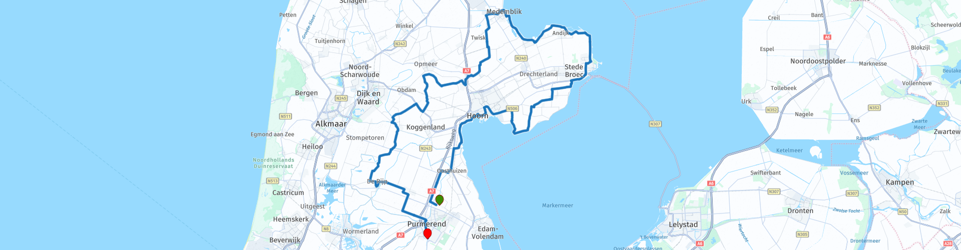
Starting point: Rest point Kwadijk
End point: AVIA XPress, Purmerend
I have awarded this route 3 stars because the scenery and attractions are exceptional and the roads are in excellent condition.
 Share this route


Animation

Verdict


Duration
3h 27m

Mode of travel
Car or motorcycle

Distance
130.53 km

Countries

 RouteXpert Review
 You start at the charming Rustpunt Kwadijk, where you immediately feel like you are stepping back in time. A narrow dike road leads you towards the vast Beemsterpolder. Here you immediately feel the peace of the landscape and the freedom of the motorbike. The straight roads, the views of farmhouses and the high Dutch skies ensure a dream start. Via Oosthuizen and Beets you head towards the Markermeer. In Hoorn you turn into the city for a short urban intermezzo. Old warehouses, a pleasant harbour and historic facades flash by. Then you dive back into nature, via Schellinkhout and Wijdenes you ride over the Zuiderdijk towards Enkhuizen - a fantastic stretch of dike riding with water on the left and pasture on the right. At Vuurtoren De Ven you reach a special Tour Info Point. This white tower from 1700 has been looking out over the IJsselmeer for centuries. You don't have to go inside to be impressed by the atmosphere and the place. A little later you drive through Andijk and Wervershoof towards Medemblik, where two special stops await you.
The Dutch Steam Engine Museum is one of the highlights of this route. You can literally hear, feel and smell the power of steam here. Perfect to combine with a break at Eetcafé De Kwikkel, a cozy café with a view of the harbor and the historic steam tram.
After Medemblik, the route turns south. You drive via country roads through villages with names like Twisk, Midwoud, Nibbixwoud and Wognum — typically West Frisian, honest and unpolished. Then you creep closer to the Beemster, where you experience the old battle against the water at the Tour Photo Point at the Museum Mill. You can look inside and imagine what life as a miller must have been like.
In the last part of the route you drive via Graft-De Rijp, a picture of a village, towards Raadhuis De Rijp. This is another Tour Photo Point that you should not miss. The Dutch Renaissance style bursts from the facades, and the square breathes the atmosphere of the Golden Age. Via Middenbeemster and Purmerend you calmly steer towards the Tour End Point: the sustainable gas station of AVIA XPress, with KFC and McDonald's right next to it. A surprising ending where you can fill your tank and your stomach.
The Koggenroute is a complete motorcycle day trip full of history, landscape and variety. You ride over narrow dikes, through straight polders and along lively port cities. The roads are good, traffic is limited and the area breathes history. Perfect for riders who like to enjoy it quietly, but also want to make a surprising stop every now and then. Start quietly in Kwadijk, end modern in Purmerend - and in between you ride through centuries of Dutch history.


 Links
Links  Usage
Usage Want to download this route?
You can download the route for free without MyRoute-app account. To do so, open the route and click 'save as'. Want to edit this route?
No problem, start by opening the route. Follow the tutorial and create your personal MyRoute-app account. After registration, your trial starts automatically.  Disclaimer
Use of this GPS route is at your own expense and risk. The route has been carefully composed and checked by a MyRoute-app accredited RouteXpert for use on TomTom, Garmin and MyRoute-app Navigation.
Changes may nevertheless have occurred due to changed circumstances, road diversions or seasonal closures. We therefore recommend checking each route before use.
Preferably use the route track in your navigation system. More information about the use of MyRoute-app can be found on the website under 'Community' or 'Academy'.