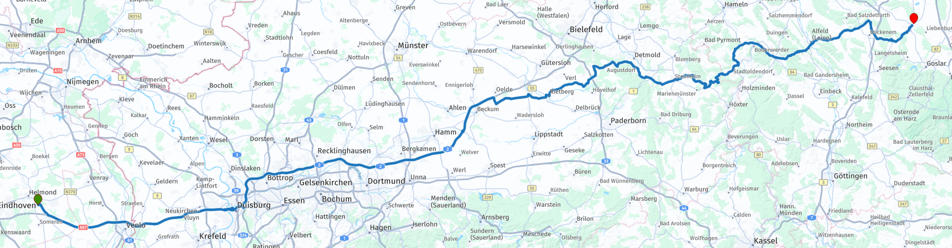
Helmond salzgitter bad

This route was brought to you by:
RouteXpert Hans van de Ven (Mr.MRA)
Last edit: 03-03-2019
 Route Summary
 The first 2 hours you drive on the highway, with a stop at the McDonalds in Lippetal. The route then goes through the military training area "Sennelager" to Hotel Rastkeller in Salzgitter-Bad.
 Share this route


Animation

Verdict


Duration
6h 25m

Mode of travel
Car or motorcycle

Distance
430.48 km

Countries


 RouteXpert Review
 After leaving the motorway, the curves increase and the surroundings become more hill and woody. Soon we drive through the military training ground "Sennelager". We drive through the Teutoburg Forest and pass the "Externsteine". A very beautiful rock formation which is worth a break.
We drive through the Naturpark Eggegebirge and the brown signs along the road indicate that you are driving on Deutsche Allee Straße. Beautiful roads with beautiful views as a result! The hills have now also become higher, which contributes to the beautiful views. Also on half-timbered houses, castles and castles no shortage on the road, unfortunately we can not take a picture of everything.
We drive through the Weserbergland and drive to the highest point of this region: the Köterberg. Here we take a sausage sandwich with coffee and we take some pictures. Even on the yellow road signs the Köterberg is signposted with an engine sign behind the name. Of course, the route lends itself here for fun steering.
Along the river Weser, we go up the hill on the left to take up only 12 hairpin bends. You have a beautiful view of the Weser and the valley.
Externesteine:
The Externsteine are a sandstone formation in the Teutoburg Forest in Germany, near Detmold. The formation consists of a few long stones that rise out of the hilly landscape abruptly. The stones are made of sandstone and originated in the Cretaceous period, about 120 million years ago. The Externsteine count as an attraction in North Rhine-Westphalia and also as a breeding ground for a riddle. This is because traces of human use from the Middle Ages, possibly from prehistoric times, have been found.
Köterberg:
Köterberg is a town in the German municipality of Lügde, North Rhine-Westphalia, and has 81 inhabitants (2005). The village lies at the foot of the hill of the same name, which at 495.8 meters is the highest point of the Kreis Lippeis. The Köterberg is also the highest hill of the Kreis Lippe, which includes the municipality of Lügde. From the village runs a short but steep road with a gradient of 14% to the top of the Köterberg. At the top of the Köterberg, a 100-meter-high telecommunication tower has been standing since 1971, visible from the wide periphery. From the top of the Köterberg you have a largely unobstructed view of the surroundings. In clear weather, the Harz Mountains and the Brocken Mountain are visible to the east, to the west the Teutoburger Forest. At the top there is also the restaurant Köterberghaus. The summit of the Köterberg is in the summer months a very famous meeting place for motorcyclists from the area. On beautiful summer days the mountain is visited by hundreds of motorcyclists, which often leads to nuisance and irritation for the villagers. (Source: Wikipedia).
Have fun while driving this route, request to give feedback via the "Reaction" option.


 Usage
Usage Want to download this route?
You can download the route for free without MyRoute-app account. To do so, open the route and click 'save as'. Want to edit this route?
No problem, start by opening the route. Follow the tutorial and create your personal MyRoute-app account. After registration, your trial starts automatically.  Disclaimer
Use of this GPS route is at your own expense and risk. The route has been carefully composed and checked by a MyRoute-app accredited RouteXpert for use on TomTom, Garmin and MyRoute-app Navigation.
Changes may nevertheless have occurred due to changed circumstances, road diversions or seasonal closures. We therefore recommend checking each route before use.
Preferably use the route track in your navigation system. More information about the use of MyRoute-app can be found on the website under 'Community' or 'Academy'.