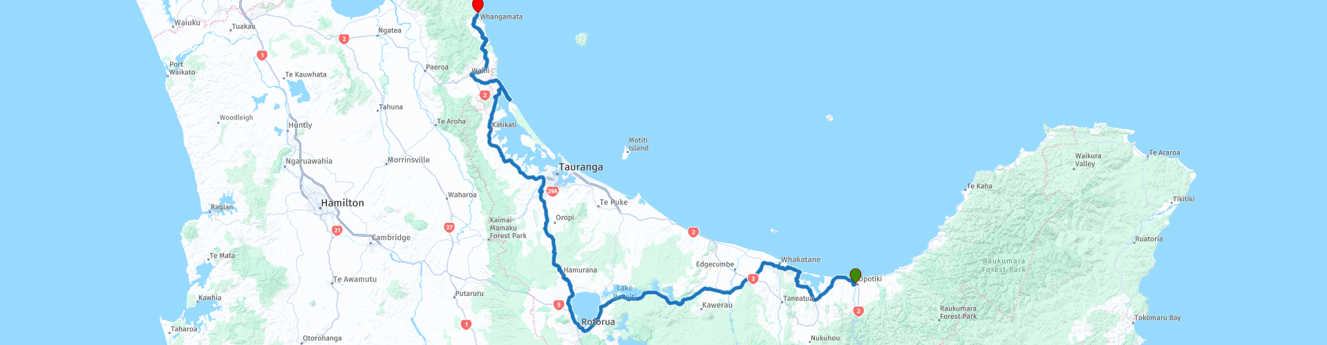
14 Opotiki to Whangamata via Rotorua

This route was brought to you by:
RouteXpert Nick Carthew - (MRA Master)
Last edit: 24-02-2021
 Route Summary
 Very good landscape, good roads and excellent attractions is why I have awarded 4**** stars for this route.
 Share this route


Animation

Verdict


Duration
8h 59m

Mode of travel
Car or motorcycle

Distance
298.40 km

Countries

 RouteXpert Review
 Soon after leaving, You'll be travelling around the large, natural Ohiwa Harbour. Relatively shallow and dotted with islands, the harbour is a major food resource for a multitude of marsh and shore birds and many wading birds can be seen on the rich mud flats at low water. Migratory birds have fattened themselves up here for their annual flight back to the northern hemisphere.
Then you cross the flat floodplain of the Rangitaiki River, the longest river in the Bay of Plenty region that flows for 155 kms. You'll see in the distance, the distinctive volcano shape of Mt Edgecumbe, or Putauaki to give it its Maori name. Captain James Cook named the mountain "Mount Edgecumbe" on 2 November 1769, possibly in honour of John Edgecombe, the sergeant of marines on his vessel, the Endeavour. The mountain rises to 820 m above sea level, and is visible from the waters of the Bay of Plenty, 30 km to the north. Every year a King of the Mountain race is run on Putauaki as part of the international King of the Mountain series, and proceeds are donated to charity.
I have suggested a coffee stop on the shore of Lake Rotoma at The Old Trout Cafe where you can enjoy views of the lake. Lake Rotoma is the fourth largest lake of the 11 lakes in the Rotorua Lakes district, or the Hot Lakes district as it was known in the early decades of the 20th century. The lake has a maximum depth of 83 m in the northern part and 73.5 m in the southern part and it's the first of a chain of four large lakes that you'll travel alongside. The next lake is Lake Rotoehu, the smallest in the chain. Formed by lava damming of a river valley, Lake Rotoehu is very shallow, although it’s able to hide a sunken island underneath its waters!
In between this and the next lake is The Wishing Tree. A large mataī tree growing beside Te Ara-o-Hinehopu, a path between Lakes Rotoiti and Rotoehu. The path is named after Hinehopu, a woman of high birth who lived in the area around 1620. It is also called Hongi’s Track, after the leader of a Ngāpuhi war party who dragged their canoes between the lakes some 200 years later. The tree is known as Hinehopu’s wishing tree – as a baby, she was hidden there from enemies by her mother.
The next attraction is Hells Gate Thermal Park. This is a must visit place. Take a guided or self-guided interactive tour of New Zealand’s most active geothermal reserve, see erupting waters, an active mud volcano, land coral and a hot waterfall.
The city of Rotorua is next. Rotorua, a town set on its namesake lake on New Zealand's North Island, is renowned for its geothermal activity and Maori culture. In Te Puia’s Whakarewarewa Valley, there are bubbling mud pools and the 30 m-tall Pohutu Geyser, which erupts many times daily. It’s also home to a living Maori village and the New Zealand Maori Arts and Crafts Institute, with traditional wood carving and weaving schools.
You can choose to stop the route here and spend a day touring all of the sites, or just stop here for lunch. I have suggested one of the fast food outlets, but there are many other choices for a lunch stop.
Leaving Rotorua on SH36, you're just 45 minutes away from the outskirts of the city of Tauranga on the coast of the Bay of Plenty. The SH2 takes you around the natural Tauranga Harbour and at RP 33, there is a nice coastal lookout at Bowentown.
From here you'll join the SH25 that will snake you to the end of the route at Whangamata. I have selected a few choices of accommodation in the links below.
Enjoy.


 Links
Links  Usage
Usage Want to download this route?
You can download the route for free without MyRoute-app account. To do so, open the route and click 'save as'. Want to edit this route?
No problem, start by opening the route. Follow the tutorial and create your personal MyRoute-app account. After registration, your trial starts automatically.  Disclaimer
Use of this GPS route is at your own expense and risk. The route has been carefully composed and checked by a MyRoute-app accredited RouteXpert for use on TomTom, Garmin and MyRoute-app Navigation.
Changes may nevertheless have occurred due to changed circumstances, road diversions or seasonal closures. We therefore recommend checking each route before use.
Preferably use the route track in your navigation system. More information about the use of MyRoute-app can be found on the website under 'Community' or 'Academy'.