05 Grano to Jokmokk

This route was brought to you by:
RouteXpert Leon Bodegom
Last edit: 20-08-2021
 Route Summary
 This was part 5 of our 2019 tour and introduction to Sweden. There is plenty to see and visit along the way. However, keep in mind the opening times of places to visit. The tourist season is short and in various places the sights were sometimes only opened after Whit Monday. In this part there are several beautiful stops for a visit and even though the number of daylight hours is high in the summer, the days are still short to see everything. The number of possible stopping places is significantly less here in the far north. Use the links in the review to the various websites for the current opening hours. Here in the north, there are fewer and fewer facilities along the route. Observe the tank and places to eat when it suits you, but pay attention to the distances to the next possible stop.
Quiet roads and curves alternate with many forests and green hills. Here in the north, the chances of spotting moose right along the road are very good. Take the wildlife crossing warning here seriously. The main roads are provided with fencing to prevent collisions with animals.
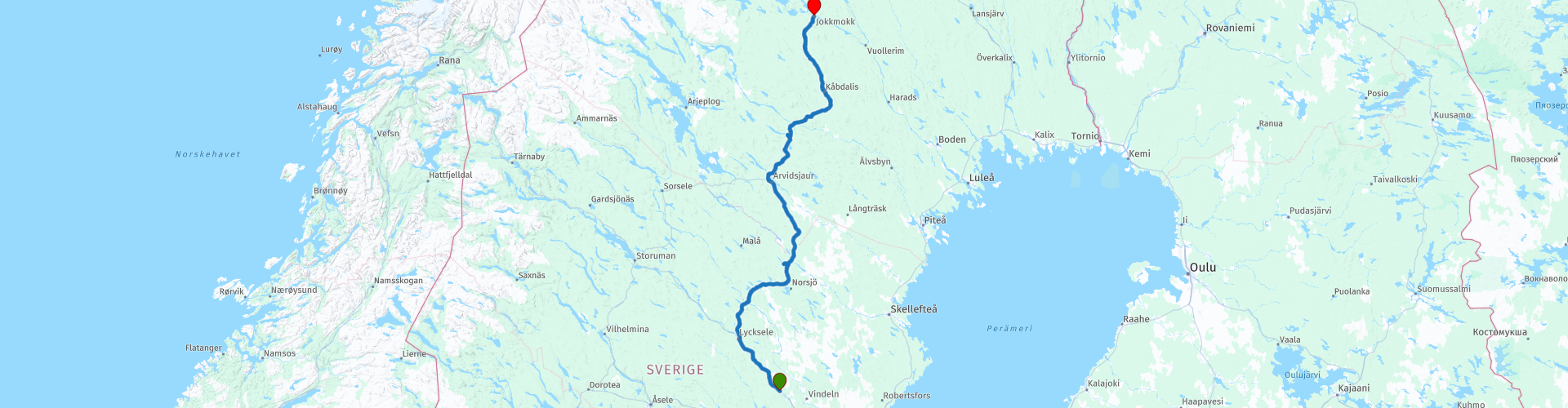
Start: Grano, Beckasin lodges and campground
End: Jokkmokk, Hotel Jokkmokk
I have awarded this route with 3 *** stars because the sloping forest landscape is pleasant and extremely quiet to drive. Enough to enjoy the surroundings. The roads are very good and the various attractions mentioned are a nice break from this journey. They are also often the places for a possible coffee stop.
 Share this route


Animation

Verdict


Duration
9h 12m

Mode of travel
Car or motorcycle

Distance
369.95 km

Countries

 RouteXpert Review
 The locations for a possible coffee stop are increasingly limited here in the north. So bringing something to eat and drink is not a wrong choice. And in this quiet area there are also plenty of places for a picnic. Drive onto a side road and you imagine yourself alone in the world.
After the first 140 Km you will drive under a cable car. Here the route goes to the starting point of the cable car. A piece of industrial heritage and it is for sale. This 13 Km long cable car is built for the transport of minerals from the mine further up the road. This solution was built because the surface was too soft for heavy transport. In the links to this route also a link to a Youtube film about this line. This line has already been used as a tourist attraction, but it is not profitable. Given the current safety requirements, it will not be easy to put this into use. Near this starting point there is also a conference center where something is available.
The route continues to go more northerly and goes directly with the rail connection. The track is then left again and then right again of your route. This track is mainly used for freight transport. You can see entire forests pass by here in the long wagons with tree trunks.
Only in Arvidsjaur is there another opportunity to buy something to eat or drink. The place does not have much to offer, most likely it is in the center where there is a pavilion next to a park. Shortly afterwards there are also some small places such as a Thai, Pizza and a Greek restaurant. But if you drive through Arvidsjaur you come just outside the built-up area at a local museum (Hembygdsmuseet). This is open all year round and they always have coffee, authentic homemade cakes / pastries and something to see too. This is a local exhibition about the life of the Sami, the original inhabitants of this northern region.
There are few roads to the north of Sweden. So this is now more of a route on the main road E45.
At Moskosel the route goes to a railway museum. Here is an exhibition of how the railway was built by hand in the early 1900s. Due to the importance of the connection, this route had to be kept open in winter. You can also see how that was / is done in the museum.
At the next place Kabdalis you will also find a few ski slopes against the hills. The height differences in the predominantly sloping landscape are not spectacular, but enough to make some descents on skis. Because of this, it will be lively with the winter day and this place will have some eateries as well. During our passage there was little to do that was open.
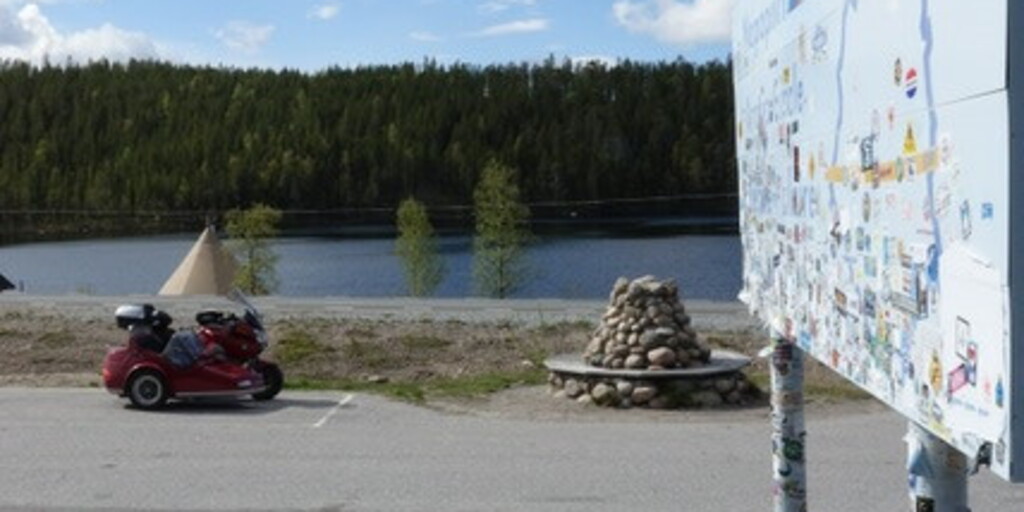
You will pass the Arctic Circle 8 kilometers before the end point. Obviously a photo stop and possibly stick a sticker on the board to leave your mark.
If you arrive in Jokmokk on time, you can still visit the Ajtte museum in this place. Here you will find an exhibition about the Sami, the original inhabitants of this part of Sweden.
For camping enthusiasts, there is also a camping pitch near the final destination. On the other side of Jokmokk as where you enter Jokmokk are the only 2 campsites that you can find in the wider area.
Except for endless cruising on quiet roads, there is also something to see on this route.

 Links
Links  Usage
Usage Want to download this route?
You can download the route for free without MyRoute-app account. To do so, open the route and click 'save as'. Want to edit this route?
No problem, start by opening the route. Follow the tutorial and create your personal MyRoute-app account. After registration, your trial starts automatically.  Disclaimer
Use of this GPS route is at your own expense and risk. The route has been carefully composed and checked by a MyRoute-app accredited RouteXpert for use on TomTom, Garmin and MyRoute-app Navigation.
Changes may nevertheless have occurred due to changed circumstances, road diversions or seasonal closures. We therefore recommend checking each route before use.
Preferably use the route track in your navigation system. More information about the use of MyRoute-app can be found on the website under 'Community' or 'Academy'.

Norrbottens lan
About this region
Norrbotten County (Swedish: Norrbottens län; Northern Sami: Norrbottena leatna, Finnish: Norrbottenin lääni) is the northernmost county or län of Sweden. It is also the largest county by land area, almost a quarter of Sweden's total area. It borders Västerbotten County to the southwest and the Gulf of Bothnia to the southeast, as well as the counties of Nordland and Troms og Finnmark in Norway to the northwest, and Lapland Province in Finland to the northeast.
The name "Norrbotten" is also used for a province of the same name. Norrbotten province covers only the eastern part of Norrbotten County – the inland mostly belongs to the Swedish Lapland province (Lappland).
The capital of Norrbotten is Luleå, whereas other significant towns include Boden, Kiruna and Piteå. The majority of the population lives in the namesake province, whereas the Lapland part of the county is sparsely populated. In terms of land area, Norrbotten is larger than both Austria and Portugal as well as the island of Ireland.
The northern part of Norrbotten lies within the Arctic Circle.
Read more on Wikipedia
The name "Norrbotten" is also used for a province of the same name. Norrbotten province covers only the eastern part of Norrbotten County – the inland mostly belongs to the Swedish Lapland province (Lappland).
The capital of Norrbotten is Luleå, whereas other significant towns include Boden, Kiruna and Piteå. The majority of the population lives in the namesake province, whereas the Lapland part of the county is sparsely populated. In terms of land area, Norrbotten is larger than both Austria and Portugal as well as the island of Ireland.
The northern part of Norrbotten lies within the Arctic Circle.
View region
 Statistics
  7
7Amount of RX reviews (Norrbottens lan)
 5920
5920Amount of visitors (Norrbottens lan)
 232
232Amount of downloads (Norrbottens lan)
 Route Collections in this region
 6500 kilometers through Scandinavia with the highlights of the Lofoten and the North Cape
The Arctic Challenge Tour, on which this 26-part tour is partly based, is not a speed race. It's a tour. It comes down to agility, good navigation and anticipation. The participants are obliged to adhere to the speed limit of the country concerned. The participants must find the ideal route with the shortest possible distance by complying 100% with the locally applicable traffic rules. Of course, also take maximum speeds into account. The organization checks for violations of the speed limit. In case of gross or repeated exceeding of the maximum speed, disqualification for the relevant stage and for the final classification will follow. Control of the route and speeds is done by means of a track and trace system. This equipment is installed in every vehicle. You can then follow each team accurately in the Back Office. Those staying at home, interested parties and participants can also see the performances of the teams, because you can be followed live via the Internet. The Back Office takes action when a team gets into trouble. (source: website The Arctic Challenge)
That's quite a luxury, having a back office behind you that keeps an eye on you. Most of us will not have that and are on our own or the fellow traveler(s). The only agreement you have with the participants is that you also have to abide by the rules. Fortunately, you don't have to complete this tour in 9 days, like the participants, but you can take it a little longer.
The highlight of the Arctic Challenge in 2020 was the Lofoten, an island group northwest of Norway. The Lofoten archipelago is located in the middle of the wild Norwegian Sea, well above the Arctic Circle. This special region offers a beautiful landscape with imposing mountains, deep fjords and long, wild sandy beaches where the sound of the seabird colonies can always be heard.
The archipelago is best known for its rich fishing tradition. The Lofoten makes a prosperous impression despite their isolated location. The entire economy revolves above all around fishing. The image of the Lofoten is mainly dominated by wooden racks with cod, which hangs to dry. Lofoten fishing has been a household name for centuries. In the middle of winter, the ships set out to catch the fish in just a few months. The rich fishing grounds are due to the North Atlantic Warm Gulf Stream around the islands, in which the fish have their spawning grounds. Oil drilling is not permitted around Lofoten and the cod spawning grounds there.
The next destination for the participants was Sirkka, also known as Levi, a winter sports resort in Finnish Lapland. They stayed there for a few days to go ice-karting and to enjoy the snow by going on a snowmobile or skiing trip. This tour also takes you to Sirkka, but instead of staying there for a few days, you have the option to continue to the North Cape, the second highlight of this trip.
Imagine a place in the far north, where the Atlantic Ocean meets the icy waters of the Arctic Ocean. This place is the North Cape in Western Finnmark in Northern Norway. From here, only the archipelago of Spitsbergen lies between you and the North Pole and the sun shines for 2.5 months at a time; from mid-May to the end of July. Many visitors admire the midnight sun or the sunset over the Barents Sea from the North Cape plateau.
With each route you will find a review with a description of the route, where you pass and what to see along the way. It is also briefly described how the participants in the Arctic Challenge in 2020 had to drive it anyway, from which point to which point. Along the way, markings (route points) have been included that indicate the end points of the stages that the participants had to complete. As mentioned, they covered the distance in 9 days, stages of more than 1000 kilometers were no exception.
Each route ends at a hotel. It is of course not an obligation to use these hotels, you can always find another place to stay in the area, that decision is up to you. My experience, however, is that they are all simple but good hotels for a very reasonable price. They are known and can be booked at booking.com.
The routes of these collections:
R01 - Puttgarden to Angelholm, 280km
R02 - Angelholm to Alingsas, 281km
R03 - Alingsas to Mysen, 261km
R04 - Mysen to Rena, 312km
R05 - Rena to Orkanger, 306km
R06 - Orkanger to Grong, 292km
R07 - Grong to Mo i Rana, 290km
R08 - Mo i Rana to Bodo, 231km
R09 - Roundtour Bodo to Lofoten part 1, 314km
R10 - Roundtour Bodo to Lofoten part 2, 250km
R11 - Roundtour Bodo to Lofoten part 3, 291km
R12 - Bodo to Arjeplog, 295km
R13 - Arjeplog to Jokkmokk, 244km
R14 - Jokkmokk to Pajala, 239km
R15 - Roundtour Sirkka to North Cape part 1, 257km
R16 - Roundtour Sirkka to North Cape part 2, 300km
R17 - Roundtour Sirkka to North Cape part 3, 244km
R18 - Roundtour Sirkka to North Cape part 4, 275km
R19 - Roundtour Sirkka to North Cape part 5, 332km
R20 - Sirkka to Kemi, 299km
R21 - Kemi to Ylivieska, 251km
R22 - Ylivieska to Jalasjarvi, 236km
R23 - Jalasjarvi to Turku, 279km
R24 - Stockholm to Askersund, 271km
R25 - Askersund to Varnamo, 224
R26 - Varnamo to Trelleborg, 259km
Have fun driving these routes!
View Route Collection