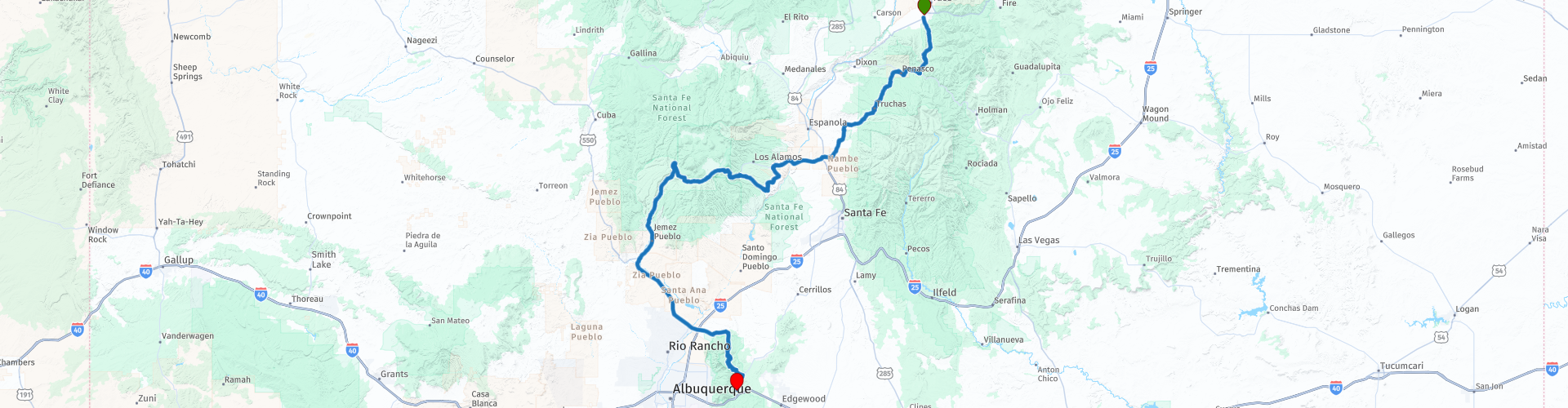
Taos to Cedar Crest New Mexico

This route was brought to you by:
RouteXpert Paul Hedges - Adv RouteXpert
Last edit: 22-01-2021
 Route Summary
  Share this route


Animation

Verdict


Duration
7h 6m

Mode of travel
Car or motorcycle

Distance
302.38 km

Countries

 RouteXpert Review
 Passing through the Carson National Forest the road runs freely, and the winding corners allow you to enjoy the surroundings as well as the riding.
Turning onto State Road the curves don't stop, and the undulating road continues to drop downhill and the skies open while you are still surrounded by the mountains in the distance.
Stopping in Chimayo take a break at Rancho de Chimayó. (RP6) It serves world-class, authentic New Mexican cuisine from recipes passed down for generations. Here’s a tip: the restaurant is known for its carne adovada—pork that has been stewed to tenderness in Chimayó red chile. Grown from original seeds passed down generations, Chimayó Heirloom chile has a unique, rich and earthy flavour.
Heading south the landscape opens out to leave the alpine like trees behind and wide-open scrublands are presented around each corner.
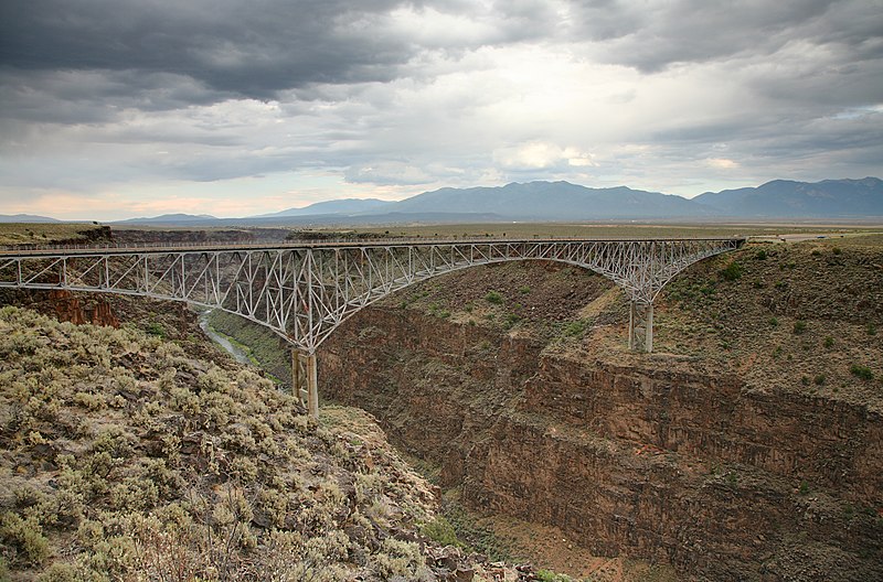
As you depart Pojoaue the road turns into a 2-lane highway and the riding takes on an easy pace as you west and you cross the Rio Grande (RP11)
The next 30 miles give a change in elevation of 4000ft as we travel along the Jemez Mountain Trail. Depart west from Los Alamos traveling through Bandelier National Monument. The road leads up more than 1,000 feet through dense forest, cresting at an elevation of 9,000. It is at this point that the view will open up to reveal the incredible Valles Caldera, a volcanic crater with grazing elk and trails to fishing and hot springs. (RP15)
Take a break at Nomad Mountain Cafe (RP17) and then continue along Route 4 as it winds downhill towards Jemez Springs stopping at The Jemez Historic Site. (RP21) The Site is a state-operated historic site on New Mexico State Road 4 in Jemez Springs, New Mexico. The site preserves the archaeological remains of the 16th-century Native American Gíusewa Pueblo and the 17th-century Spanish colonial mission called San José de los Jémez.
Crossing the Rio Grande once again we circumvent Albuquerque and into the Cibole National Forest. Word of warning, the tarmac turns into dirt as you proceed along Highway 165 towards Sandia Cave. (RP30) Road Closed during the winter from this point. There may be road closures from RP (29) in the winter months. To avoid, after (RP 27) take the US-85 south to Albuquerque then the I-40 east to Cedar Crest.
Sandia Cave was first discovered and excavated in the 1930s, the site exhibits evidence of human use from 9,000 to 11,000 years ago. The road is twisty and steep but worth the excitement, or should that be terror as the winding road takes you through a mix of alpine forest and desert scrub before we finish the trip at Cedar Crest


 Links
Links  Usage
Usage Want to download this route?
You can download the route for free without MyRoute-app account. To do so, open the route and click 'save as'. Want to edit this route?
No problem, start by opening the route. Follow the tutorial and create your personal MyRoute-app account. After registration, your trial starts automatically.  Disclaimer
Use of this GPS route is at your own expense and risk. The route has been carefully composed and checked by a MyRoute-app accredited RouteXpert for use on TomTom, Garmin and MyRoute-app Navigation.
Changes may nevertheless have occurred due to changed circumstances, road diversions or seasonal closures. We therefore recommend checking each route before use.
Preferably use the route track in your navigation system. More information about the use of MyRoute-app can be found on the website under 'Community' or 'Academy'.
New Mexico
About this region
New Mexico (Spanish: Nuevo México [ˈnweβo ˈmexiko] (listen); Navajo: Yootó Hahoodzo [joː˩tʰo˥ ha˩hoː˩tso˩]) is a state in the Southwestern United States. It is one of the Mountain States of the southern Rocky Mountains, sharing the Four Corners region of the western U.S. with Utah, Colorado, and Arizona, and bordering Texas to the east and southeast, Oklahoma to the northeast, and the Mexican states of Chihuahua and Sonora to the south. The state capital is Santa Fe, which is the oldest capital in the U.S., founded in 1610 as the government seat of Nuevo México in New Spain; the largest city is Albuquerque.
New Mexico is the fifth-largest of the fifty states, but with just over 2.1 million residents, ranks 36th in population and 46th in population density. Its climate and geography are highly varied, ranging from forested mountains to sparse deserts; the northern and eastern regions exhibit a colder alpine climate, while the west and south are warmer and more arid; the Rio Grande and its fertile valley runs from north-to-south, creating a riparian climate through the center of the state that supports a bosque habitat and distinct Albuquerque Basin climate. One–third of New Mexico's land is federally owned, and the state hosts many protected wilderness areas and national monuments, including three UNESCO World Heritage Sites.
New Mexico's economy is highly diversified, with major sectors including oil drilling, mineral extraction, dryland farming, cattle ranching, acequia and landrace agriculture, lumber, retail, scientific research laboratories, technological development, and the arts, especially textiles and visual arts. Its total gross domestic product (GDP) in 2020 was $95.73 billion, with a GDP per capita of roughly $46,300. State tax policy is characterized by low to moderate taxation of resident personal income by national standards, with tax credits, exemptions, and special considerations for military personnel and favorable industries; subsequently, its film industry is one of the largest and fastest growing in the country. Due to its large area and economic climate, New Mexico has a significant U.S. military presence, most notably the White Sands Missile Range, and many U.S. national security agencies base their research and testing arms in the state, such as the Sandia and Los Alamos National Laboratories, known as Project Y during the 1940s; here, the Manhattan Project was responsible for the world's first atomic bomb and first nuclear test, Trinity.
In prehistoric times, New Mexico was home to Ancestral Puebloans, Mogollon, and the modern Comanche and Utes. Spanish explorers and settlers arrived in the 16th century, naming the territory Nuevo México after the Aztec Valley of Mexico, more than 250 years before the establishment and naming of the present-day country of Mexico; thus, the state did not derive its name from Mexico. Isolated by its rugged terrain and the relative dominance of its indigenous people, New Mexico was a peripheral part of the viceroyalty of New Spain. Following Mexican independence in 1821, it became an autonomous region of Mexico, though this autonomy was increasingly threatened by the centralizing policies of the Mexican government, culminating in the Revolt of 1837; at the same time, the region became more economically dependent on the United States. At the conclusion of the Mexican–American War in 1848, the U.S. annexed New Mexico as part of the larger New Mexico Territory. It played a central role in American westward expansion, and was admitted to the Union in 1912.
New Mexico's history has contributed to its unique demographic and cultural character. One of only six majority-minority states, it has the nation's highest percentage of Hispanic and Latino Americans and the second-highest percentage of Native Americans after Alaska. New Mexico is home to part of the Navajo Nation, 19 federally recognized Pueblo communities, and three different federally recognized Apache tribes. Its large Hispanic population includes Hispanos, who descend from early Spanish settlers, as well as Chicanos and Mexicans. The New Mexican flag, which is among the most recognizable in the U.S., reflects the state's eclectic origins, bearing the scarlet and gold coloration of Spain's Cross of Burgundy along with the ancient sun symbol of the Zia, a Puebloan tribe. The confluence of indigenous, Spanish, Mexican, Hispanic, and American influences is also evident in New Mexico's unique cuisine, music genre, and architecture.
Read more on Wikipedia
New Mexico is the fifth-largest of the fifty states, but with just over 2.1 million residents, ranks 36th in population and 46th in population density. Its climate and geography are highly varied, ranging from forested mountains to sparse deserts; the northern and eastern regions exhibit a colder alpine climate, while the west and south are warmer and more arid; the Rio Grande and its fertile valley runs from north-to-south, creating a riparian climate through the center of the state that supports a bosque habitat and distinct Albuquerque Basin climate. One–third of New Mexico's land is federally owned, and the state hosts many protected wilderness areas and national monuments, including three UNESCO World Heritage Sites.
New Mexico's economy is highly diversified, with major sectors including oil drilling, mineral extraction, dryland farming, cattle ranching, acequia and landrace agriculture, lumber, retail, scientific research laboratories, technological development, and the arts, especially textiles and visual arts. Its total gross domestic product (GDP) in 2020 was $95.73 billion, with a GDP per capita of roughly $46,300. State tax policy is characterized by low to moderate taxation of resident personal income by national standards, with tax credits, exemptions, and special considerations for military personnel and favorable industries; subsequently, its film industry is one of the largest and fastest growing in the country. Due to its large area and economic climate, New Mexico has a significant U.S. military presence, most notably the White Sands Missile Range, and many U.S. national security agencies base their research and testing arms in the state, such as the Sandia and Los Alamos National Laboratories, known as Project Y during the 1940s; here, the Manhattan Project was responsible for the world's first atomic bomb and first nuclear test, Trinity.
In prehistoric times, New Mexico was home to Ancestral Puebloans, Mogollon, and the modern Comanche and Utes. Spanish explorers and settlers arrived in the 16th century, naming the territory Nuevo México after the Aztec Valley of Mexico, more than 250 years before the establishment and naming of the present-day country of Mexico; thus, the state did not derive its name from Mexico. Isolated by its rugged terrain and the relative dominance of its indigenous people, New Mexico was a peripheral part of the viceroyalty of New Spain. Following Mexican independence in 1821, it became an autonomous region of Mexico, though this autonomy was increasingly threatened by the centralizing policies of the Mexican government, culminating in the Revolt of 1837; at the same time, the region became more economically dependent on the United States. At the conclusion of the Mexican–American War in 1848, the U.S. annexed New Mexico as part of the larger New Mexico Territory. It played a central role in American westward expansion, and was admitted to the Union in 1912.
New Mexico's history has contributed to its unique demographic and cultural character. One of only six majority-minority states, it has the nation's highest percentage of Hispanic and Latino Americans and the second-highest percentage of Native Americans after Alaska. New Mexico is home to part of the Navajo Nation, 19 federally recognized Pueblo communities, and three different federally recognized Apache tribes. Its large Hispanic population includes Hispanos, who descend from early Spanish settlers, as well as Chicanos and Mexicans. The New Mexican flag, which is among the most recognizable in the U.S., reflects the state's eclectic origins, bearing the scarlet and gold coloration of Spain's Cross of Burgundy along with the ancient sun symbol of the Zia, a Puebloan tribe. The confluence of indigenous, Spanish, Mexican, Hispanic, and American influences is also evident in New Mexico's unique cuisine, music genre, and architecture.
View region
 Statistics
  9
9Amount of RX reviews (New Mexico)
 14569
14569Amount of visitors (New Mexico)
 99
99Amount of downloads (New Mexico)
 Route Collections in this region
 Coast to Coast Across the USA
14 Days across the USA
Start the trip at Daytona Pier on the Atlantic Coast.
Through 14 days you will visit New Orleans, Memphis, Tulsa, Colorado Springs, Las Vegas and Los Angeles. See the sights of Monument and Death Valley, the Hoover Dam. Ride across 12 US States for 4267 miles of adventure before ending the trip on Santa Monica Pier, Los Angeles on the Pacific Coast
View Route Collection
A USA Road Trip East from LA
This is a 20 day trip that was 2 Years in the planning. Across 13 US States ticking off bucket list entries along the way.
• Riding up the Pacific Coast Highway and then visiting Yosemite Park in California.
• The extremes of Death Valley and LAs Vegas in Nevada.
• The scenic overload that was Utah, Zion and Bryce National Parks, Monument Valley and the Moki Dugway.
• Colorado and the Million Dollar Highway and San Juan Skyway
• New Mexico and the Rio Grande and the Cimarron Canyon State Park
• To Texas and the wide open spaces and the biggest steak known to man.
• Oklahoma will deliver Route 66 and iconic picture opportunities
• Arkansas offers up the Pig Trail and a chance to ride through The Ozarks.
• Tennessee gives us Memphis and Nashville a musical overload as well as The Jack Daniels Distillery
• Mississippi means you can travel along the Natchez Trace Parkway and just take it easy.
• Georgia and The Carolinas are home to The Blue Ridge Parkway that winds through The Smoky Mountains.
• Virginia brings you the Shenandoah National Park and Skyline drive
See a different horizon around each corner that just seems to beat the previous one for beauty. All the while marvelling at how each few miles the surrounding scenery can be so vastly different.
Ride some of the top roads in America who’s names appear on Top Ten list all over the internet. 3 even appear in the World top 20.
• Pacific Coast Highway
• Blue Ridge Parkway
• Tail of the Dragon
• Grand Staircase–Escalante National Monument Ride
• Natchez Trace Parkway
• Million Dollar Highway
• Cherohala Skyway
• San Juan Mountain Skyway
• Pig Trail Scenic Byway
• Moki Dugway
This trip is about maximising memories to last a lifetime
View Route Collection