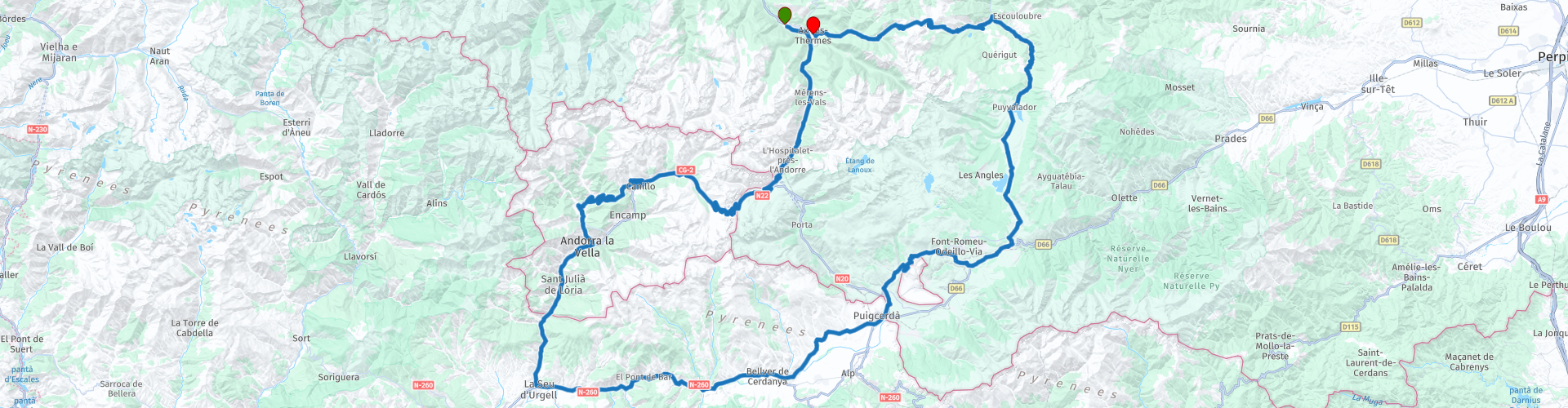
Roundtrip from Ax les Thermes to Andorra and the Cerdagne

Cet itinéraire a été créé par:
RouteXpert Catherine De Groote RouteXpert
Dernière modification: 18-12-2023
 Résumé de l'itinéraire
 Le nom Cerdagne ou Cerdanya est principalement utilisé du côté espagnol de la frontière. En France, on parle officiellement des Pyrénées catalanes, comme le montre également le nom du Parc Naturel Régional des Pyrénées Catalanes, le parc naturel autour duquel passe notre itinéraire. Mais la frontière ne signifie pas grand-chose pour les habitants de cette zone qui la considèrent comme une partie intégrante de la Catalogne. Andorre n'est pas incluse ; c'est un État nain avec ses propres lois et un paysage grandiose qui contraste fortement avec la triste monotonie des villes.
Sur cet itinéraire à travers les montagnes vous rencontrerez plusieurs cols de près de 2000 m d'altitude. La plupart d'entre eux sont fermés d'octobre à avril à cause de la neige. En montagne, le temps peut changer complètement très rapidement. Par conséquent, emportez toujours avec vous des vêtements chauds et imperméables, même si le soleil est haut dans le ciel lorsque vous sortez.
Hormis quelques très rares et courts tronçons de routes en moins bonne qualité, cette balade offre des vues phénoménales du début à la fin et vous roulez sur des routes asphaltées magnifiquement entretenues. Cela signifie profiter de la belle région sous tous ses aspects. L'itinéraire reçoit donc 5 étoiles sans hésitation.
 Partager cet itinéraire


Animation

Verdict


Durée
9h 16m

Mode de déplacement
Voiture ou moto

Distance
247.73 km

Pays


 RouteXpert Review
 Ax-les-Thermes attire les visiteurs toute l'année : ils viennent se promener l'été, skier l'hiver et se faire soigner toute l'année. On ne compte pas moins de quatre-vingts sources, avec une température allant de 18 à 78 °C. Sur la place du Breilh, aux portes de la vieille ville, les vapeurs s'élèvent du chaud Bassin des Ladres (1250). Le roi Louis le Saint le fit construire pour ses soldats revenus des croisades atteints de lèpre. Le bassin acquit par la suite d'autres fonctions, on y lavait par exemple des vêtements ou des cochons fraîchement abattus... Vous trouverez également des sources et des fontaines dans les rues, entre des maisons à colombages du Moyen Âge.
Quittez Ax par la N20 en direction de l'Espagne et d'Andorre. Ce n'est pas une route difficile, mais aux beaux jours, elle peut être très fréquentée et donc dangereuse, notamment à cause des bus touristiques et des groupes de motocyclistes en direction ou en provenance du Pas de la Casa. Il y a une surveillance régulière, surtout le week-end, et il y a toujours un contrôle radar dans la vallée. Environ 30 km plus loin, vous atteignez la frontière d'Andorre et du Pas de la Case. El Pas de la Casa doit son nom à une cabane de berger qui se trouvait ici au début du XXe siècle (Pas vient de col, casa signifie « maison » ou « cabane »).
C'est le village le plus haut de la principauté, mais surtout un paradis pour ceux qui souhaitent faire leurs achats hors taxes. Il est occupé toute l'année.
Suivez la direction d'Andorre-la-Vieille, non pas la route via le tunnel, mais la route qui passe par le Port d'Envalira. Juste à la sortie du Pas, vous passerez devant plusieurs stations-service où l'essence est très bon marché : une excellente occasion de faire le plein de carburant pour le reste de la journée.
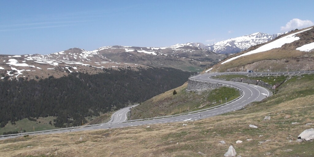
Port d'Envalira peut parfois être recouvert de neige, mais le problème est toujours résolu dans les 24 heures. À 2408 mètres, c'est le plus haut col de la chaîne de montagnes par laquelle passe une route et c'est aussi le plus haut col d'Europe ouvert toute l'année.
Veuillez noter qu'il peut faire très froid à cause du vent. Le col est situé sur la ligne de partage des eaux entre la mer Méditerranée, dans laquelle se jette la Valira, et l'océan Atlantique, dans lequel se jette l'Ariège. Vous contemplez les montagnes d'Andorre (jusqu'à 2942 m).
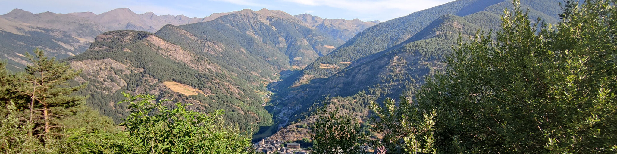
Lors de la belle descente vous verrez le Pic deis Pessons au sud. À Canillo, tournez à droite et suivez une belle route. Depuis le Collet de Montaup - et plus particulièrement depuis le point de vue du Roc des Quer - vous pourrez observer le travail des glaciers d'Andorre pendant 2,6 millions d'années, qui ont façonné le relief actuel en forme de U des vallées. Une autre caractéristique frappante de ce point de vue est la présence d'oiseaux de proie très particuliers. Certains sont visibles toute l'année, comme l'aigle royal, le gypaète barbu ou la buse variable, et d'autres uniquement lors de la reproduction ou de passage en été, comme la buse domestique, le milan noir ou l'aigle serpent. Vous aurez également la chance d'apercevoir quelques mouflons sauter, car ils vivent en moyenne et haute montagne.
Le long de cette route étroite, vous avez quelques points de vue sur les montagnes environnantes.
La vallée d'Andorre était une zone de production de fer entre le XVIIe et le XVIIIe siècle. La forge de Rossell, à La Sassana, est l'un des exemples les mieux conservés de cette industrie sidérurgique des Pyrénées.
Andorre-la-Vieille, la capitale d'Andorre, est une métropole moderne : bruyante et polluée par un trafic intense. Ici aussi, de nombreuses personnes viennent faire leurs courses dans les grands centres commerciaux. C'est plus calme dans les rues du centre historique, entre les vieilles maisons.
! En dehors de la ville, à Sant Julià de Lèria, tournez à gauche en direction des villages d'Aixirivall et Juberri si vous souhaitez ajouter une boucle supplémentaire (en option, 25 km, comptez 45 min) au parcours, sur des routes de montagne très très éloignées. de l'agitation urbaine de la vallée ont été supprimés. Soyez prudent lorsque vous revenez sur la route principale : il y a souvent des embouteillages vers le poste frontière avec l'Espagne.
Après le passage de la frontière, vous trouverez le restaurant Masia D'en Valenti le long de la N145. Ceci est situé dans un cadre magnifique dans la vallée de Valls de Valira. Cette propriété du XVIIIe siècle dispose d'un restaurant et d'une terrasse avec vue sur la campagne environnante. Le restaurant est super, la nourriture est incroyablement bonne, le service est tout simplement parfait. La propreté et le service sont tout simplement géniaux. Le prix était extrêmement bas pour la qualité du repas.
La route de liaison de La Seu d'Urgell à Puigcerdà, par le plateau de Cerdagne, est moins intéressante.
Si vous souhaitez visiter le Bunker Park Martinet i Montellà de Cerdanya, tournez à droite à Martinet. Veuillez prévoir plus de temps pour cela. Il existe un centre d'interprétation dédié à l'histoire de la ligne P, une série de bunkers construits par Franco après la Seconde Guerre mondiale. Le centre organise des visites guidées de huit des bunkers encore debout à Martinet i Montellà. Les bunkers ne peuvent être visités qu'avec un guide et durent un peu moins de deux heures, selon les conditions météorologiques. C'est peut-être un peu trop pour cette balade.
Traversez la frontière derrière Puigcerdà jusqu'au petit village d'Ur. A côté de l'église il est agréable de se détendre sur la terrasse du restaurant Pénates avec une boisson, une glace ou autre gourmandise.
Vous prenez maintenant la direction de Font-Romeu et vous traversez ensuite Llivia, une enclave espagnole en France.
La région de Font-Romeu a une histoire fascinante dans le domaine de l'énergie durable. La région bénéficie du plus grand nombre d'heures d'ensoleillement de France et c'est pourquoi le premier four solaire au monde a été construit à Mont-Louis en 1953, suivi dix ans plus tard par le deuxième à Odeillo et en 1983 par la centrale solaire de Thémis. Tous trois sont ouverts au public et fournissent de nombreuses informations (y compris scientifiques).
Vous repartez ensuite sur une belle partie du parcours à travers la pinède de Bolquère. Elle s'étend entre Font-Romeu et Mont-Louis, la plus haute forteresse de France. Montez ensuite jusqu'au col de la Quillane, derrière lequel commence le plateau du Capcir. La route traverse la vallée et offre des vues sur des coteaux bordés de forêts de pins des deux côtés. En hiver, c'est le domaine des skieurs de fond. Il existe également de nombreux lacs dans la région, naturels et artificiels, comme celui de Maternale et de Puyvalador.
Au-delà de Puyvalador, vous êtes de plus en plus encerclé par des parois rocheuses jusqu'à traverser les gorges de l'Aude. Là où la route est creusée dans la paroi rocheuse, les virages sont plus serrés et la qualité de l'asphalte est moins bonne. Restez concentré et ralentissez si vous souhaitez admirer le paysage.
A la croisée de deux vallées, au niveau des ruines du Château d'Usson, tourner à gauche pour revenir à Ax-les-Thermes via le Port de Pailhères.
À Ax-les-Thermes, vous pouvez garer votre moto sur le parking spacieux juste à côté du centre sans circulation, ce qui est intéressant si vous souhaitez explorer le centre-ville chaleureux ou profiter de cette belle visite sur une terrasse.

 Liens
Liens  Utilisation
 Vous voulez télécharger cette route?
Vous pouvez télécharger l'itinéraire gratuitement sans compte MyRoute-app. Pour ce faire, ouvrez l'itinéraire et cliquez sur 'enregistrer sous'. Vous voulez éditer cette route?
Pas de problème, commencez par ouvrir la route. Suivez le tutoriel et créez votre compte personnel MyRoute-app. Après l'enregistrement, votre essai démarre automatiquement.  Avertissement
L'utilisation de cet itinéraire GPS est à vos propres frais et risques. L'itinéraire a été soigneusement composé et vérifié par un RouteXpert accrédité par MyRoute-app pour une utilisation sur TomTom, Garmin et MyRoute-app Navigation.
Des modifications peuvent néanmoins s'être produites en raison de circonstances modifiées, de déviations de routes ou de fermetures saisonnières. Nous vous recommandons donc de vérifier chaque itinéraire avant de l'utiliser.
Utilisez de préférence le tracé de l'itinéraire dans votre système de navigation. Plus d'informations sur le l'utilisation de MyRoute-app peut être trouvée sur le site Web sous 'Communauté' ou 'Académie'

Andorra
À propos de cette région
L'Andorre, en forme longue la Principauté d'Andorre (en catalan : Andorra et Principat d’Andorra), est un État d'Europe du Sud et, selon certaines définitions, de l'Ouest. Bordée par l'Espagne et la France (donc enclavée dans l'Union européenne), et située dans le massif des Pyrénées, elle est principalement constituée de montagnes élevées.
Le pays ne fait pas partie de la zone euro, ni de l'Union européenne, mais utilise cependant l'euro depuis la création de cette monnaie, et ne frappe ses propres pièces que depuis le 1er juillet 2013 en vertu de l'Accord monétaire signé avec la Commission européenne.
Il s'agit d'un des plus petits États souverains d'Europe, avec une superficie de 468 km2 et une population estimée à 78 015 habitants en 2020. Établie à 1 023 mètres au-dessus du niveau de la mer, Andorre-la-Vieille, sa capitale, est la plus haute d'Europe. La langue officielle est le catalan, la monnaie officielle est l'euro. La devise de l'Andorre est « Virtus Unita Fortior », et son drapeau est constitué de trois bandes verticales bleue, jaune et rouge, la bande jaune étant plaquée de l'écusson andorran. L'hymne national est El Gran Carlemany.
La principauté, dont la création remonte à 780 sous le règne de Charlemagne, est régie par un système unique, le paréage de 1278 et 1288. Ce contrat de droit féodal concède le trône andorran à deux coprinces, l'évêque catalan d'Urgell et le comte de Foix (dont les droits et devoirs sont passés successivement au roi de Basse-Navarre, puis au roi de France à partir de Henri IV, et enfin au chef d'État français). L'Andorre est sortie de son isolement au XXe siècle, durant lequel elle a profité de son cadre naturel et a utilisé un système fiscal avantageux pour devenir une grande destination touristique, accueillant près de trois millions de visiteurs chaque année. Si la principauté est réputée aujourd'hui pour ses pistes de ski et ses faibles taxes, elle est aussi souvent considérée comme un paradis fiscal. Elle est membre des Nations unies depuis 1993, du Conseil de l'Europe, mais pas de l'Union européenne.
En savoir plus sur Wikipedia
Le pays ne fait pas partie de la zone euro, ni de l'Union européenne, mais utilise cependant l'euro depuis la création de cette monnaie, et ne frappe ses propres pièces que depuis le 1er juillet 2013 en vertu de l'Accord monétaire signé avec la Commission européenne.
Il s'agit d'un des plus petits États souverains d'Europe, avec une superficie de 468 km2 et une population estimée à 78 015 habitants en 2020. Établie à 1 023 mètres au-dessus du niveau de la mer, Andorre-la-Vieille, sa capitale, est la plus haute d'Europe. La langue officielle est le catalan, la monnaie officielle est l'euro. La devise de l'Andorre est « Virtus Unita Fortior », et son drapeau est constitué de trois bandes verticales bleue, jaune et rouge, la bande jaune étant plaquée de l'écusson andorran. L'hymne national est El Gran Carlemany.
La principauté, dont la création remonte à 780 sous le règne de Charlemagne, est régie par un système unique, le paréage de 1278 et 1288. Ce contrat de droit féodal concède le trône andorran à deux coprinces, l'évêque catalan d'Urgell et le comte de Foix (dont les droits et devoirs sont passés successivement au roi de Basse-Navarre, puis au roi de France à partir de Henri IV, et enfin au chef d'État français). L'Andorre est sortie de son isolement au XXe siècle, durant lequel elle a profité de son cadre naturel et a utilisé un système fiscal avantageux pour devenir une grande destination touristique, accueillant près de trois millions de visiteurs chaque année. Si la principauté est réputée aujourd'hui pour ses pistes de ski et ses faibles taxes, elle est aussi souvent considérée comme un paradis fiscal. Elle est membre des Nations unies depuis 1993, du Conseil de l'Europe, mais pas de l'Union européenne.
Afficher la région
 Statistiques
  15
15Nombre de critiques RX (Andorra)
 21430
21430Nombre de visiteurs (Andorra)
 2133
2133Nombre de téléchargements (Andorra)
 Acheminer les collections dans cette région
 Aller-retour de 7 jours de Gérone à la Catalogne Andorre et les Pyrénées
Les Pyrénées s'étendent sur plus de 450 kilomètres du golfe de Gascogne à l'ouest jusqu'au Cap de Creus sur la Méditerranée. La chaîne de montagnes, avec des sommets de plus de 3000 mètres, forme une barrière naturelle qui coupe la péninsule ibérique du reste de l'Europe. La crête principale de la chaîne de montagnes forme également en grande partie la frontière d'État entre la France et l'Espagne, tandis que le micro-État Andorre se situe entre ces deux pays.
Bordant les Pyrénées se trouve la Catalogne, l'arrière-pays de Barcelone. Pas étonnant que de nombreux nouveaux modèles de motos soient présentés à la presse en Catalogne. Il existe de nombreuses façons de tester les nouveaux modèles là-bas. Un avantage supplémentaire est qu'il est très silencieux ! Vous diriez presque « trop calme » car il y a un risque qu'à un moment donné vous utilisiez toute la largeur de la route, sous le couvert de « vous ne verrez pas la circulation venant en sens inverse ici ». et restez du côté droit de la ligne médiane.
Ces sept itinéraires de cette collection traversent ces belles régions. Chacune de ces routes où surtout les flancs des pneus ont du mal. Que ce soit sur les pentes douces de Catalogne ou sur les routes en balcon des Gorges des Pyrénées françaises, assurez-vous qu'ils soient excités, car vous pouvez parier que ça va être excitant !
Quelques sites sont discutés dans l'examen pour chaque itinéraire. Ceux-ci racontent souvent quelque chose sur l'histoire de la région dans laquelle vous conduisez. Faits amusants, assez instructifs. Il y a aussi des endroits où vous pouvez faire le plein et où vous pouvez boire un café et/ou déjeuner. Vous êtes totalement libre de visiter ces lieux, vous pouvez bien sûr également déterminer vos propres points d'intérêt.
Mais la principale chose pour laquelle vous avez probablement voyagé dans cette région est simplement la conduite. Et comme mentionné plus haut, vous êtes dans un véritable paradis de la moto où la direction est fantastique !
Chaque itinéraire se termine dans un hôtel. Ce n'est bien sûr pas une obligation d'utiliser ces hôtels, vous pouvez toujours trouver un autre endroit où séjourner dans la région, cette décision vous appartient. Mon expérience, cependant, est que ce sont tous des hôtels simples mais bons pour un prix très raisonnable. Ils sont connus et peuvent être réservés sur booking.com.
Les parcours de ces collections :
R01 - Gérone à Sant Julia de Loria, 269 km
R02 - Sant Julia de Loria à Pierrefitte Nestalas, 290km
R03 - Pierrefitte Nestalas à Barbastro, 291km
R04 - De Barbastro à Puig Reig, 266km
R05 - Puig Reig à Figueres, 268km
R06 - Figueres à Quillan, 243km
R07 - Quillan à Géronam, 286km
Amusez-vous à conduire ces routes!
Afficher la collection d'itinéraires
Circuit de 5 jours des Pyrénées espagnoles à Andorre et à travers la France jusqu'aux Alpes
Un circuit de 5 jours avec 5 itinéraires qui relient et vous emmènent des contreforts espagnols des Pyrénées, à travers la Principauté d'Andorre et à travers la France jusqu'aux Alpes.
Au départ de La Seu d'Urgell, connue comme la porte d'entrée d'Andorre, ce circuit de 5 jours recherche les routes les plus excitantes et les plus pittoresques sur lesquelles vous pourrez voyager. Certains des faits saillants comprennent:
Andorre et la plus haute route goudronnée des Pyrénées à 2408m.
Le Col de Pailheres à 2001m avec 24 virages en épingle.
Les Gorges de l'Aude, les Gorges de Saint Georges et les Gorges de Galamus sont toutes dans les Pyrénées françaises.
La belle cité médiévale fortifiée de Carcassonne.
Minerve est un village médiéval bien préservé niché sur un éperon rocheux et entouré d'un réseau de falaises, de ponts naturels et de canyons.
Le spectaculaire viaduc de Millau, l'un des ponts les plus hauts du monde, culminant à 343 mètres.
Les belles Gorges du Tarn et les Gorges de l'Ardèche.
Pont-en-Royans, charmant et pittoresque village du Parc Naturel Régional du Vercors dont les vieilles maisons surplombent la Bourne.
Combe Laval, souvent reconnue comme la plus magnifique de toutes les routes balcons françaises.
Et puis c'est virage en épingle à cheveux après virage en épingle à cheveux que vous voyagez de Grenoble à Chambéry avec peut-être le plus spectaculaire étant les Lacets du Montvernier avec sa série de 17 virages en épingle à cheveux serrés grimpant 277m en seulement 3,4 km.
C'est une visite que vous n'oublierez jamais.
Afficher la collection d'itinéraires