Binnendoor naar Lombardije van Oberammergau naar Edolo

This route was brought to you by:
RouteXpert Hans van de Ven (Mr.MRA)
Last edit: 11-02-2023
 Route Summary
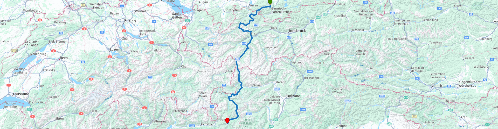
 Start: Oberammergau
Finish: Edolo
The route made the same for TomTom, Garmin and MyRoute-app Navigation users.
If you want to ride this TT, keep the info below in mind:
- A lot of mountain experience
- TT from A to B
- Accommodation necessary
- Tol
Source: Promoter 07, September / October 2018.
 Share this route


Animation

Verdict


Duration
5h 41m

Mode of travel
Car or motorcycle

Distance
330.56 km

Countries


 RouteXpert Review
 Passes: Ammersattel (1118 m), Namloser Sattel (1365 m), Hahntennjoch (1884 m), Pillerhöhe (1558 m), Kaunertaler Gletscherstraße (2750 m), Finstermünz pass (1188 m), Reschen pass (1504 m), Umbrail pass (2501 m) ), Stilfser Joch (2758 m), Passo di Gavia (2618 m)
Route details:
- Winter closure: Hahntennjoch, Kaunertaler Gletscherstraße and the Umbrail pass from November to May, Stilfser Joch (Stelvio) until June. Gaviapas from December to May
- Toll: Kauntertaler Gletscherstraße
- Alternative routes: The alternative in the Kaunertal to the glacier road of the same name starts in Prutz at the top of the Inn Valley. For those who find the 48 steep and tight hairpin bends on the Vinschgau side of the Stilfser Joch (Stelvio) too exciting, opt for the Umbrail Pass route.
- Ideal months: June, July, September and October. August is the Italian holiday month, with a lot of traffic and high hotel prices.
- Driving pleasure: Piller Höhe, Kaunertaler Gletscherstraße, Stilfser Joch, Gaviapas
- Landscape: Ammersattel, Plansee, Stilfser Joch / Ortler massif, Umbrail pass, Gaviapass.
This 5-star route is one of the 24 most beautiful Alpine routes in recent years!
Colored route points:
rp 1 - Starting point in Oberammergau at Zauberstub * n
rp 2 - Ammersattel
rp 8 - Namlospass
rp 13 - Coffee stop at Gasthaus Pfafflar
rp 14 - Hahntennjoch
rp 23 - Pillerhöhe
rp 25 - Finstermünzpass
rp 26 - Photo opportunity at the Panzergarten
rp 27 - Tank option at the BP
rp 28 - Lunch stop at the Reschnerhof
rp 29 - Photo point at the sunken church
rp 36 - Viewpoint Pass Stelvio
rp 37 - Passo Stelvio
rp 38 - Viewpoint / coffee stop at Alpengasthof Tibet Hütte - Albergo e Ristorante Rifugio Tibet
rp 40 - Stelvio viewpoint
rp 47 - Coffee stop at La Ruota
rp 49 - Passo di Gavia
rp 53 - End point in Euro Hotel & Tanken at IP


 Links
Links  Usage
Usage Want to download this route?
You can download the route for free without MyRoute-app account. To do so, open the route and click 'save as'. Want to edit this route?
No problem, start by opening the route. Follow the tutorial and create your personal MyRoute-app account. After registration, your trial starts automatically.  Disclaimer
Use of this GPS route is at your own expense and risk. The route has been carefully composed and checked by a MyRoute-app accredited RouteXpert for use on TomTom, Garmin and MyRoute-app Navigation.
Changes may nevertheless have occurred due to changed circumstances, road diversions or seasonal closures. We therefore recommend checking each route before use.
Preferably use the route track in your navigation system. More information about the use of MyRoute-app can be found on the website under 'Community' or 'Academy'.