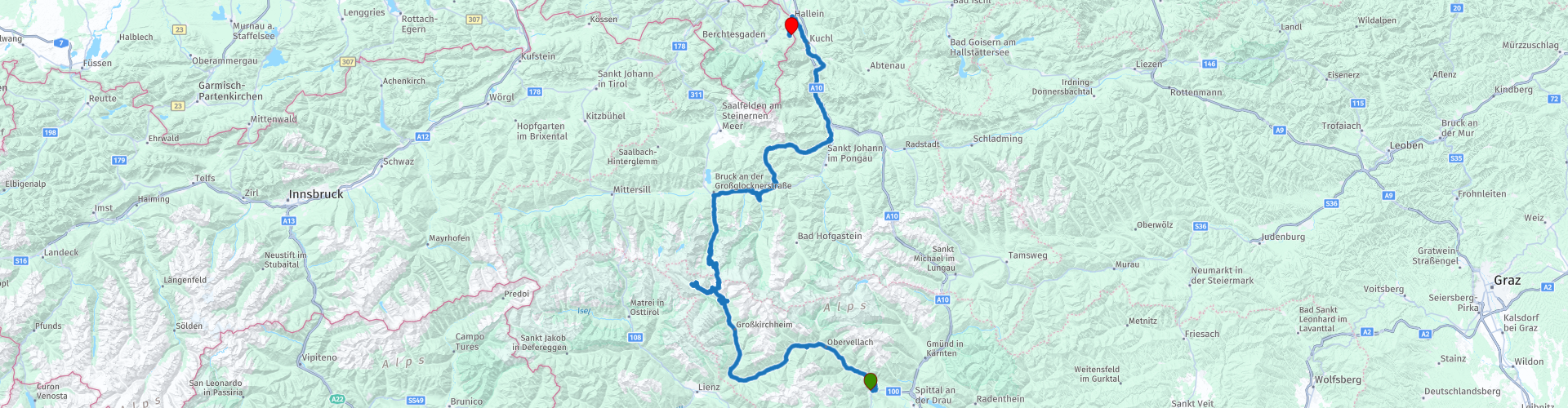
15 From Sachsenburg to Berchtesgaden via Grossglockner mountain pass

This route was brought to you by:
RouteXpert Leonor Orban - Sr. RouteXpert
Last edit: 11-04-2021
 Route Summary
 With a little detour over wonderful Alpine passes you continue your way to Germany today. Take the time to enjoy everything you encounter along the way. On the Großglockner High Alpine Road, via the Kaiser-Franz-Josefs-Höhe you can admire the (retreating) Pasterze glacier as well as the highest accessible point: the Edelweißspitze.
Once you have said goodbye to this alpine street, you drive over the Dientner Sattel towards Bischofshofen and Salzburg. Why take the main road, when you can also drive a modest mountain pass?
Eventually you cross the border at Hallein to Germany, Berchtesgaden. At the foot of the Roßfeld Panoramastraße you settle down at a wonderful mountain hotel, where you can catch up on everything you have seen and done today. Not only impressive mountain passes are on the menu, but also a number of beautiful sights. Think of the Raggaschlucht, Jungfernsprung, Burg Hohenwerfen, Salzachklamm and of course "the Sound of Music".
 Share this route


Animation

Verdict


Duration
6h 38m

Mode of travel
Car or motorcycle

Distance
247.90 km

Countries

 RouteXpert Review
 Today you say goodbye to Austria. We make it a special goodbye. The Großglockner High Alpine Road is on the "to-do list"! Many motorcyclists have stuck the famous Großglockner sticker somewhere on his or her motorcycle. You get this when you purchase a ticket to conquer the Großglockner. At the end of the morning, you can also attach it to your motorcycle (or one of your suitcases).
Despite the fact that your MRA or other type of navigation is very likely to navigate fine, you can also use the landscape as a navigation method during this route. Pretty soon, after leaving the hotel in Sachsenburg, you cross the Möll (rp 3). This river originates at an altitude of about 2400m in the Hohe Tauern National Park. The Pasterze glacier feeds this mountain stream (in Celtic “Molina”… hence the name Möll) and further towards the valley the river increases in strength and you will regularly see people kayaking or rafting on the river because of this wild water.
You follow the river upstream to Flattach. Here is one of the first sights along the route: the Raggaschlucht (rp 4). The roughly 800 meters long and narrow gorge was created because the water of the Ragga brook has, over a period of thousands of years, carved its way through the rocks. Since the end of the 19th century, the gorge has been made accessible to pedestrians. Even nowadays you can only walk through the gorge on the wooden stairs and railings. The water from the brook still rushes through the gorge, making it an overwhelming walk. The steep cliffs and narrow passages certainly contribute to this overwhelming feeling. Keep in mind that the walk takes about an hour.
After this cooling hike (it is on average 10 degrees cooler in the gorge than outside the gorge) you continue the road along the Möll towards the Großglockner. As you drive down the B107 your eye will most likely catch something glittering in the distance. It remains there and the closer you get, the more it becomes clear that it is an immense waterfall. The Jungfernsprung can be seen from afar. To prevent your attention from straying too far from driving, you can stop on the way at a nearby parking lot (rp 5). From the wooden platform you can take magnificent photos of the 130m high waterfall.
You will also have noticed that the beginning of the Großglockner High Alpine Road cannot be too far away. The climb towards the Hohe Tauern has started slowly and you pass a number of places that signal that you are on the right path. Thus, the "Haus der Steinböcke" (rp 6) is a clear hint. This museum was set up in honor of the ibex (ibex). Fortunately, this special animal has once again become a characteristic image of the Hohe Tauern National Park. The animal was reintroduced to the area around 1960 ... and with success. Today about 1100 ibex live in the National Park. With a bit of luck you may encounter a small herd along the way. They like to move in rocky areas. Where as a person you can hardly walk. Do you see a lonely ibex? Then there is a good chance that it is an already elderly animal.
Once past the toll booth (rp 7) and deeper into the nature reserve, you have the chance to encounter other wild animals. Think of the many marmots, chamois, eagles and the impressive golden eagle. Various viewpoints have been included on the panoramic mountain pass. Not only to admire the great mountains, but also to spot these wild animals.
Two trips (or dead ends) are included on the Großglockner High Alpine Road. The first is the road to the Kaiser-Franz-Josefs-Höhe. If you have followed the Möll river (or your MRA navigation) properly, you will have arrived at this viewpoint without any difficulty. This point owes its name to the famous husband of Empress Sisi: Emperor Franz-Josef. The emperor was a renowned mountain enthusiast and regularly visited the mountains for hiking and climbing. This also applies to the Pasterze glacier. In 1856 he visited the national park to hike from Heiligenblut to this viewpoint on the glacier. At the time, the view of the glacier must have been spectacular. The glacier, then about 17 km long, reached from a distance to the feet of the emperor. Nowadays (due to a melting process of 10m! Per year) the current glacier is only 8.4km long. You can clearly see the old traces of the glacier still in the valley. From this point you also have a magnificent view of the highest mountain in this nature reserve: the Großglockner (3798m). The viewpoint is easy to visit and offers the opportunity to stock up on the necessary souvenirs and to take a break in the restaurant.
You can drive all the way to the end of the road, where there is a wide range of motorcycle parking spaces. This immediately betrays the tourist character of the Hoogalpenweg.
In the 1930s, one could not have imagined how immensely touristy this mountain pass would become. The then poor Austria was looking for ways to boost the economy. In 1930 3200 people were put to work to build the 48 km long road through the Hohe Tauern in 4 years. After 1.6 million shifts, the mountain road was finished and in 1934 the first motorcycles and cars really drove over the pass. Every year around 120,000 passers-by were expected. This estimate was quickly exceeded and the number was even exceeded tenfold in 1962. So keep it in mind while on the road. It's busy, people stop regularly (and sometimes unexpectedly) to take in the view. The mountain pass proves above all to be one of quiet enjoyment, instead of driving fast with the optimal driving line.
The second (dead end) road is to the Edelweißspitze (rp 11). This is the highest point on your route and can be reached via a number of nasty hairpin turns with cobblestones. Once you have arrived at the top you can enjoy the National Park in 360 degrees and possibly also take a break at the Edelweißhütte. After this you start on the last (of a total of 36) hairpin bends of this mountain pass.
Your arrival in the town of Bruck marks the end of your ride on the Hoogalpenweg. As the Möll was your guide this morning, it is the Salzach this afternoon. This river has a length of 227 km and guides you to Hallein. The Salzach owes its name to its historical function. Salt (Salz) in particular was transported over the river to various cities. It was a perfect route, as the river also connects to the Danube and opened up an even wider area.
To make navigating somewhat challenging, we leave the river temporarily just after Taxenbach. You will have noticed that the B311 is quite busy. To get around this, and to be able to drive one last Alpine pass, turn off towards the Dientner Sattel (rp 13). This pass reaches a modest height of 1357m, but offers a wonderful, quiet and winding alternative to the busy B311 up to Bischofshofen. You can also take a break here at Berggasthof Mittereggalm.
Back in Bischofshofen, the Salzach resumes her guiding task. For the next hour you follow this river to Hallein. In between you can, if you still have time, decide to visit a number of sights. In the village of Werfen (rp 15) you can visit Castle Hohenwerfen or drive up the mountain to a "the Sound of Music" film location.
Do you prefer nature? Then you can pause at the top of Pass Lueg and visit the Salzachklamm (rp 16). The Salzach has carved an 80 meter deep gorge in the limestone. You can visit the gorge on foot; possibly accompanied by a nature guide. This offers you the chance to experience the "Flying Fox" ... if you are not yet experiencing enough speed on your motorcycle.
As a quieter alternative you can also visit the Gollinger waterfall (rp 17) further up the route. it can be visited on foot (about 10 minutes walking from the car park) and is described as romantic and attractive.
After these optional sights, say goodbye to the Salzach at Hallein. You are now entering the Berchtesgadener Alps and the equivalent National Park. Located in Austria and Germany, this area marks your border crossing into Germany. This time without mandatory passport checks. The route takes you at a leisurely pace to today's end point: Berggasthof Pechhäusl at the foot of the Roßfeld Panoramastraße. Prepare ... tomorrow is your morning gym!
Without a doubt, this route is an absolute winner to drive. The Großglockner High Alpine Road is always impressive. How many times you have ridden this mountain pass, it remains a real pleasure. That alone makes the route worth 5 stars. Together with the plentiful supply of easily accessible natural attractions, this ride has become an Alpine classic that you will not soon forget.


 Links
Links  Usage
Usage Want to download this route?
You can download the route for free without MyRoute-app account. To do so, open the route and click 'save as'. Want to edit this route?
No problem, start by opening the route. Follow the tutorial and create your personal MyRoute-app account. After registration, your trial starts automatically.  Disclaimer
Use of this GPS route is at your own expense and risk. The route has been carefully composed and checked by a MyRoute-app accredited RouteXpert for use on TomTom, Garmin and MyRoute-app Navigation.
Changes may nevertheless have occurred due to changed circumstances, road diversions or seasonal closures. We therefore recommend checking each route before use.
Preferably use the route track in your navigation system. More information about the use of MyRoute-app can be found on the website under 'Community' or 'Academy'.

Salzburg
About this region
Salzburg (Austrian German: [ˈsaltsbʊʁk], German: [ˈzaltsbʊʁk] (listen); literally "Salt Fortress"; Austro-Bavarian: Soizbuag) is the fourth-largest city in Austria. In 2020, it had a population of 156,872.The town is on the site of the Roman settlement of Iuvavum. Salzburg was founded as an episcopal see in 696 and became a seat of the archbishop in 798. Its main sources of income were salt extraction, trade and gold mining. The fortress of Hohensalzburg, one of the largest medieval fortresses in Europe, dates from the 11th century. In the 17th century, Salzburg became a centre of the Counter-Reformation, with monasteries and numerous Baroque churches built.
Salzburg's historic centre (German: Altstadt) is renowned for its Baroque architecture and is one of the best-preserved city centres north of the Alps. The historic center was enlisted as a UNESCO World Heritage Site in 1996. The city has three universities and a large population of students. Tourists also visit Salzburg to tour the historic centre and the scenic Alpine surroundings. Salzburg was the birthplace of the 18th-century composer Wolfgang Amadeus Mozart.
Read more on Wikipedia
Salzburg's historic centre (German: Altstadt) is renowned for its Baroque architecture and is one of the best-preserved city centres north of the Alps. The historic center was enlisted as a UNESCO World Heritage Site in 1996. The city has three universities and a large population of students. Tourists also visit Salzburg to tour the historic centre and the scenic Alpine surroundings. Salzburg was the birthplace of the 18th-century composer Wolfgang Amadeus Mozart.
View region
 Statistics
  13
13Amount of RX reviews (Salzburg)
 18154
18154Amount of visitors (Salzburg)
 1878
1878Amount of downloads (Salzburg)
 Route Collections in this region
 The 24 Most Beautiful Alpine Routes
The Alps, The Alps are a mountain range in Europe, stretching from the French Mediterranean coast in the southwest to the Pannonian Plain in the east. The area of the mountain range is more than 200,000 km².
In other words Passes and Mountain Roads!
Driving through the mountains is great! Especially over the mountain passes with hairpin bends and narrow winding roads. Every bend a different view where you can enjoy. There are many beautiful mountain passes in the Alps.
A selection that has also been incorporated into these routes:
The Stlevio Pass:
The Stelvio Pass, also known as Passo dello Stelvio, is mainly known for the stage in the Giro d'Italia. Due to the length and the difference in height, this pass is seen as one of the toughest tests in cycling. The Stelvio Pass reaches a maximum height of 2758 meters and is therefore one of the highest in the Alps. The pass connects the towns of Bormio and Prato Allo Stelvio. In winter the pass is closed due to heavy snowfall.
The Reschenpass:
The Reschenpass, also known as Passo di Resia, connects the Austrian state of Tyrol with the Italian province of South Tyrol. The pass reaches a maximum height of 1,504 meters and has been one of the most important north-south connections in the Alps in recent centuries. The pass was used long before Roman times. Along the way you will pass several highlights and historical relics. One of the highlights is the Reschensee. This lake was created after the construction of the dam and has completely submerged the village of Graun. The only thing that reminds of that is the clock tower in the middle of the lake.
Col du Galibier:
The French mountain pass Col du Galibier connects the towns of Saint-Michel-de-Maurienne and Briançon via the Col du Lautaret in the south and the Col du Télégraphe in the north. The mountain pass is part of the Tour de France and very much feared, due to the fact that it can only be reached via the other two mountain passes. The pass reaches a maximum height of 2646 meters. From there you can take a walk to the viewpoint at 2704 meters. You can admire the peaks of the Grand Galibier, Mont Blanc and La Meije here.
The Grossglockner High Alpine Road:
With a height of 3798 meters the Grossglockner is the highest mountain in Austria. To fully enjoy this impressive mountain, you can drive over the Grossglockner High Alpine Road and the accompanying pass. The route starts from Bruck am Grossglockner and ends in Heiligenblut. Of course you can drive in two directions. The pass reaches a maximum height of 2504 meters and is closed in winter due to heavy snowfall. Along the way you pass several stops with fun activities, information points, mountain huts and viewpoints. A visit to the Kaiser-Franz-Josefs-Höhe and Pasterzen Glacier is highly recommended.
The Col d'Izoard:
Just like the Col du Galibier, the Col d'Izoard is also part of a stage of the Tour de France. The mountain pass connects Briançon with the valley of the river Guil. The pass is partly located in the Regional Natural Park du Queyras and reaches a maximum height of 2360 meters. What is special about the Col d'Izoard is the barren and rocky landscape. Sometimes it feels like driving a car over the moon! Along the way you can stop at several points to enjoy the beautiful view.
The Bernina Pass:
The Bernina Express is one of the most famous rail trains in Switzerland and the Alps. The route is beautiful and partly included on the UNESCO World Heritage List. Parallel to the railway lies the Bernina pass, which connects the Veltlin valley with the Egandin valley. This beautiful Alpine road has a total length of 56 kilometers and reaches a maximum height of 2328 meters. Along the way you can enjoy views of the Morteratsch Glacier.
The Sella Pass:
The Sella Pass, also known as Passo di Sella, takes you over one of the most impressive mountain ranges in the Dolomites: the Sella massif. The pass connects Valle di Fassa with Val Gardena and reaches a maximum height of 2236 meters. At this height is also the border of the Italian provinces of Trentino and Bolzano. Along the way you can enjoy the view of this spectacular mountain world. Admire, for example, the three peaks of the Sasso Lungo massif, the Sella massif or the peaks of the Marmolada. You can also drive the Sella pass in combination with the Gardena pass, Pordoi pass and Campolongo pass.
The Grimsel Pass:
The Grimsel Pass connects Goms in Wallis with the Halis Valley in the Bernese Oberland. The pass reaches a maximum elevation of 2165 meters and is closed in winter due to snowfall. Over the centuries, the mountain pass has played an important role in trade between Switzerland and Italy. Now it is mainly the reservoirs that have an important function. These are used to generate electricity. The landscape you drive through is rugged, rocky and impressive. On top of the pass is a hotel and a restaurant with a special marmot park. The Dodensee (Totensee) is also located here. This lake owes its name to the many soldiers who died in the time of Napoleon.
The Gotthard Pass:
The Gotthard Pass, also known as Passo del San Gottardo and Saint Gotthard, connects the Swiss towns of Airolo and Andermatt. The mountain pass and associated tunnel are especially known among holidaymakers driving from Switzerland to Italy. But where the majority opt for the tunnel, it is precisely the pass that really completes the holiday. The Gotthard Pass has a length of about 26 kilometers and reaches a maximum height of 2106 meters. The route is beautiful and takes you along old villages and beautiful views.
The Silvretta High Alpine Road and Silvretta Pass:
The Paznaun Valley in Tyrol and the Montafon in Vorarlberg are connected by the Silvretta High Alpine Road. The route has a length of 22.3 kilometers and leads from Galtür to Partenen in 34 hairpin bends, via the 2032 meter high Bielerhöhe. The Silvrettasee is also located at this point, where you can enjoy a lovely walk. The pass is closed in winter due to snowfall.
The Simplon Pass:
Just like the Gotthard Pass, many holidaymakers also travel over the Simplon Pass every year. This mountain pass connects the Rhone Valley in the canton of Valais with the Valle d'Ossola in Piemonte. The pass is open all year round and reaches a maximum height of 2005 meters. Along the way you pass a number of buildings, including the well-known Simplon Hospiz from 1825. The hospiz is managed by the monks of St. Bernard. From the highest point on the pass, all kinds of hiking routes are possible and you will also come across a hotel where you can spend the night.
The Gerlos Pass:
The Gerlos Pass connects the Salzach Valley in the Salzburgerland with the Zillertal Valley in Tyrol. The pass is part of the Gerlos Alpenstraße and runs right through the Hohe Tauern National Park. Along the way you can enjoy beautiful views of the surroundings. The pass has a length of 12 kilometers and reaches a maximum height of 1531 meters. A ride over the Gerlos Pass can be ideally combined with a visit to the Krimmler Wasserfälle.
The Great St. Bernard Pass:
The Great St. Bernard Pass, better known as Col du Grand Saint Bernard, connects the Italian province of Valle d'Aosta with the Swiss canton of Valais. The pass is one of the highest in Switzerland and reaches a maximum height of 2469 meters. Like a number of other mountain passes in this list, the Great St. Bernard Pass has also been used as a connecting road for centuries. The pass is named after the St. Bernard dogs that used to help stranded travelers along with the monks. The pass is closed in winter.
The Timmelsjoch High Alpine Road:
The Timmelsjoch High Alpine Road connects the towns of Sölden in the Ötztal and Meran in South Tyrol. Tolls must be paid on the Hochgurgl - Moos route. Via a mountain road with about 60 hairpin bends you drive through a beautiful mountain world. With the Timmelsjoch Experience you can learn more about the history, the road and the environment via various stations. You can also visit the Top Mountain Crosspoint museum.
Col de l'Iseran:
With a maximum pass height of 2770 meters, the Col l'Iséran is one of the highest mountain passes in the Alps. The pass connects Bourg-Saint-Maurice with Bonneval-sur-Arc. Via a road full of hairpin bends you pass, among other things, Val-d'Isère and a side valley of the Maurienne that lies entirely in the National Park de la Vanoise. You can spot animals such as marmots and chamois and there is also a restaurant with a chapel on top of the pass.
The Gavia Pass:
The Gavia Pass (Italian Passo di Gavia) is a mountain pass in the Italian Alps, in the Lombardy region.
It is one of the highest pass roads in Europe. The road leads through the unspoilt Stelvio National Park. The road was built in the First World War to supply Italian soldiers who fought in the Italian-Austrian border area. The pass height is one of the most beautiful in the Alps. Here is the large Lago Bianco with, to the north, the mountain San Matteo (3684 meters). Lago Nero is slightly lower on the south side of the pass. Here the mountain group of the Adamello determines the view. There are many well-marked walks in the area. During the winter the pass is closed due to the heavy snowfall. The pass is often closed until May and June due to the large amount of snow.
Promoter has made a selection of the 24 Most Beautiful Alpine routes that they have set out in recent years.
The routes go through:
France
Austria
Switzerland
Italy
The most beautiful roads, the most beautiful views, the most beautiful viewpoints. The highest mountains, the fastest descents, hairpin bend after hairpin bend, you name it you can't get enough of it.
If you go on holiday in this region, take advantage of it, ALL routes in this collection have been checked and made equal for TomTom, Garmin and MyRoute-app Navigation by a MyRoute-app RouteXpert.
Have fun with this collection and while driving one of these routes. Enjoy all the beauty that the Alps and the Dolomites have to offer. Click on “View route” to read the review of the chosen route.
I would like to hear your findings about the route(s).
View Route Collection
The 12 most beautiful car and motorcycle routes in Carinthia
“Motorradland Kärnten” where you feel so wonderfully welcome as a motorcyclist!
Own website for motorcyclists, own curated routes, hotels, campsites and guest houses with attention for motorcyclists, a wonderful area where motorcyclists are very popular.
Kärnten or Carinthia, at the crossroads of the Germanic, Slavic and Roman worlds. Three cultures within a few kilometres, southern flair, culinary delights, cross-border tours. Breakfast in Italy, lunch in Slovenia, dinner in Austria - all in one day. Experience the diversity in the borderless Alps-Adriatic region, the area for motorcyclists.
Extensive day trips on winding mountain paths, romantic panoramic routes and beautiful lakes, here the 12 TOP routes Kärnten / Carinthia. Enjoy!
View Route Collection