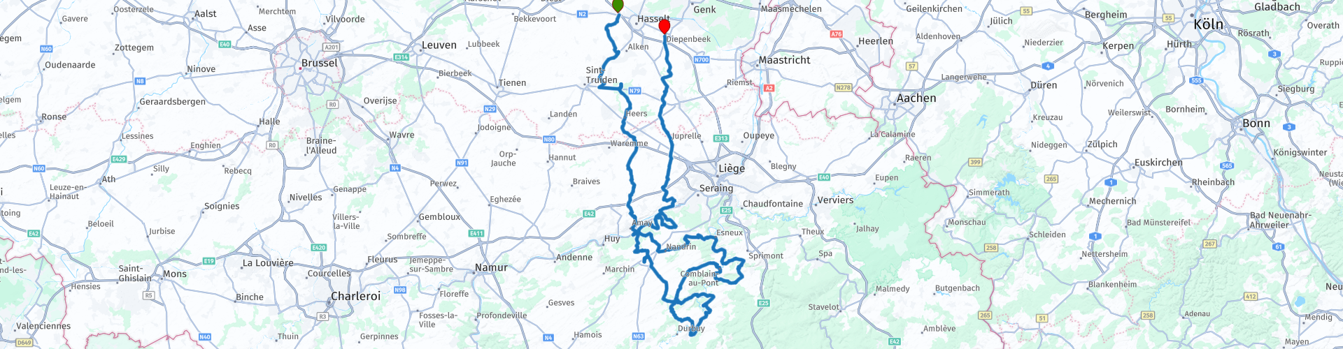
Roundtrip Hasselt Diepenbeek throughout the Condroz

This route was brought to you by:
RouteXpert Guy Heyns - Adv. RouteXpert
Last edit: 10-12-2024
 Route Summary
 The original name 'Mad bends through the Condroz' was attractive enough to try the route for yourself first.
We were soon convinced that the quality of the route was more than sufficient to turn it into a Route Expert route.
Not for softies, but super fun for cornering enthusiasts.
 Share this route


Animation

Verdict


Duration
6h 12m

Mode of travel
Car or motorcycle

Distance
264.20 km

Countries

 RouteXpert Review
 In our opinion, the quality of 'Mad bends through the Condroz' was high enough not only to invite us to ride them, but also to further develop them, with Frank's permission, into an Expert route in our library. . Thank you Frank!
The route starts at the large, inviting car park of the Carrefour in Kuringen. Easily accessible, large, safe and equipped with all necessary amenities for picnic shopping or even for breakfast / lunch / dinner, depending on the time of day.
The route takes you fairly quickly to the Walloon part of the country (rp6) where there is a different speed limit. From here you are allowed to drive 90 km / h outside the city limits, compared to only 70 km / h on the other side of the (language) border. Interesting point that you should pay attention to!
After all, 90 km / h is a pleasant speed to enjoy this route. It may be a little less interesting for the regular tourist visitor, but for the technical motorcyclist the route is more than challenging enough. That is why it might be best not to take softies on this trip. Some pins are a bit on the sharp and steep side, while the fast pieces can also be interpreted as such. The average speed may still exceed the level of the beginner. And a forewarned man ....
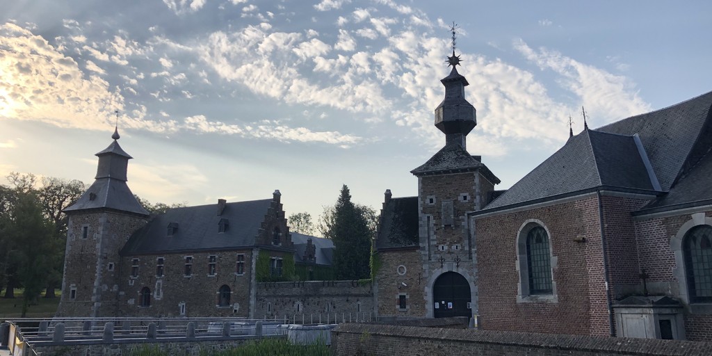
The route is certainly varied and that will become clear to you as soon as you leave the first resting point of the route, café 'Le Tambour' (rp 12) behind you. Le Tambour can be reached just after the magnificent approach to the Castle of Jehay (rp 11), an enchantingly beautiful, unique (!) And rare 16th century castle from the Meuse Renaissance. In 2020, in full restoration, but both the inside and the outside are more than worth a visit, especially for lovers of eclectic art and history. For example, the castle even has a 19th-century refrigerator in which the ice that was 'harvested' in winter was stored.
At route point 14 you will pass the Maas river for the first time and then the party really starts. Nice sharp turns are interspersed with wonderfully long stretches at a very varied pace. Steering skills and load changing technology can be refined here extensively and that during a few wonderfully long kilometers.
Until route point 27 you can enjoy undisturbed the region, the excellent road surface, the nice squeezing bends and slopes. But a break at route point 27 is highly recommended, especially if you have a picnic in the top case. The municipality of Comblain-La-Tour has created an excellent picnic spot here on the banks of the Ourthe. Moreover, with ample parking space. However, if you or your travel companions need to make use of any toilet facilities, we recommend that you continue the tour and digest the curves further up to Poulseur (rp 33, 22 km) or Esneux (rp 34, 26 km).
Poulseur (rp 33) has a very pleasant market square with ample parking space. If you wish, a visit can be made to the only 'lock' on the Ourthe, which was built in the 19th century, when there was still limited shipping on the Ourthe. Today, the value of the lock can be called more biological and a short trip to it is also nice.
A nice alternative to a sanitary break is Esneux, which is only 4 km away. Perhaps a little busier, but here too you can enjoy what the name of the café promises you on the banks of the Ourthe in café Belle-Vue: a magnificent view of the castle of Fy, a fairytale-like castle in private property that you can watch mysteriously and in full Disney atmosphere from the hill.
From Esneux you can take a seat on your steel steed and continue to enjoy the wonderful curves that this technical playground lets wash under your tires.
Here and there on the route towards route point 44, where you cross the Maas for the second time, small 'white' things will attract your attention. You may not even notice it, but it becomes more and more clear along the way. Especially if you cross the Maas at route point 44. A glance to the left will undoubtedly lead you to a completely 'white' factory, which is fiercely protruding from its surroundings. However, white is the color of this region because of the many limestone quarries present. After all, large mountains of 'chalk' are waiting here to be processed into the famous 'gyproc' building components that may also be in stock in your home. So now you also know where they come from ...
Once you have passed the Maas back, a few very nice and quickly consecutive pins will lead you back to the 'long' lanes on which you will return to Flanders at route point 50. Pay attention to the new maximum speed outside the center: 70 km / h is now the limit again.
Pleasant roads will take you via the last petrol station on the route at route point 54 to the Market Square of Diepenbeek, where there are pleasant establishments in addition to an extensive parking zone. Here you can enjoy this wonderfully technical tour.
The route has its length, but every kilometer is worth it. Excellent road surfaces and some superior long roads and sneaky corners have undoubtedly contributed to the refinement of your steering technique and load changing skills. Just because this route can be driven 'at pace' and you still have some driving experience, we do not really recommend this route to beginners. However, to the more advanced rider who cannot visit the Eifel or Luxembourg every weekend and still wants to enjoy fun cornering. Moreover, the route is close enough to Flanders to make it a quick trip. The route also remains far enough away from the 'beaten' paths and the tourist attractions, so that the crowds are really not too bad.
This deserves the route a five star rating, not so much because of the tourist attractions, but because of its technicality. We would therefore like to repeat our thanks to colleague Frank Jordens for the initial impetus to this tasty route to digest.

 Links
Links  Usage
Usage Want to download this route?
You can download the route for free without MyRoute-app account. To do so, open the route and click 'save as'. Want to edit this route?
No problem, start by opening the route. Follow the tutorial and create your personal MyRoute-app account. After registration, your trial starts automatically.  Disclaimer
Use of this GPS route is at your own expense and risk. The route has been carefully composed and checked by a MyRoute-app accredited RouteXpert for use on TomTom, Garmin and MyRoute-app Navigation.
Changes may nevertheless have occurred due to changed circumstances, road diversions or seasonal closures. We therefore recommend checking each route before use.
Preferably use the route track in your navigation system. More information about the use of MyRoute-app can be found on the website under 'Community' or 'Academy'.

Liège Province
About this region
Liège (French: [ljɛʒ]; Walloon: Lîdje [liːtʃ]; Dutch: Luik [lœyk] (About this soundlisten); German: Lüttich [ˈlʏtɪç] (About this soundlisten)) is the easternmost province of Wallonia and Belgium.
It borders (clockwise from the north) the Dutch province of Limburg, the German states of North Rhine-Westphalia and Rhineland-Palatinate, Diekirch in Luxembourg, the Belgian Walloon (French-speaking) provinces of Luxembourg, Namur and Walloon Brabant and the Belgian Flemish (Dutch-speaking) provinces of Flemish Brabant and Limburg.
Part of the eastern-most area of the province, bordering Germany, is the German-speaking region of Eupen-Malmedy, which became part of Belgium in the aftermath of World War I.
The capital and the largest city of the province is the city of the same name, Liège. The province has an area of 3,857 km2 (1,489 sq mi), and a population of 1,106,992 as of January 2019.[4]
Read more on Wikipedia
It borders (clockwise from the north) the Dutch province of Limburg, the German states of North Rhine-Westphalia and Rhineland-Palatinate, Diekirch in Luxembourg, the Belgian Walloon (French-speaking) provinces of Luxembourg, Namur and Walloon Brabant and the Belgian Flemish (Dutch-speaking) provinces of Flemish Brabant and Limburg.
Part of the eastern-most area of the province, bordering Germany, is the German-speaking region of Eupen-Malmedy, which became part of Belgium in the aftermath of World War I.
The capital and the largest city of the province is the city of the same name, Liège. The province has an area of 3,857 km2 (1,489 sq mi), and a population of 1,106,992 as of January 2019.[4]
View region
 Statistics
  74
74Amount of RX reviews (Liège Province)
 37230
37230Amount of visitors (Liège Province)
 17512
17512Amount of downloads (Liège Province)
 Route Collections in this region
 The 10 most beautiful car and motorcycle routes in Limburg
Limburg, who thinks of Limburg, thinks of flan, coal mines, marl and the hill country. The coal mines have been closed for almost 40 years, the last load of coal was brought up from the Oranje-Nassau coal mine in Heerlen on 31 December and, as they say, South Limburg was transformed from Black to Green and unfortunately there is still little left. view of this period.
But not only pie, marl and coal in Limburg, but also a very beautiful province to tour by car or motorcycle and enjoy all the beauty that the province of Limburg has to offer. For this, the MyRoute app RouteXpert has put together a Top 10 of Car and Motorcycle routes for you.
All routes in this collection have been checked and made equal for TomTom, Garmin and MyRoute-app Navigation by a MyRoute-app RouteXpert.
If you think, I have a very nice route that should certainly not be missing from this collection, send it to:
email: routeexpert@myrouteapp.com
Subject: New Route for the Top 10 collection Province of Limburg composed by Hans van de Ven.
The route will then be reviewed and then added to the Top 10.
To make the Top 10 also the Top 10, 1 route will have to disappear from the Top 10, you can indicate this when submitting the new route.
Have fun with this collection and while driving one of these routes. Enjoy all the beauty that the Netherlands and in particular the province of Limburg has to offer. Click on “View route” to read the review of the chosen route.
I would like to hear your findings about the route(s).
View Route Collection
Top 5 Car and Motorcycle Routes in the Eifel
The Eifel is the eastern part of the medium plateau Eifel-Ardennes. It is located north of the Moselle and west of the Rhine. The largest part is in Germany, a small part is in Belgium, in the East Cantons. The German part of Eifel is located in the federal states of North Rhine-Westphalia and Rhineland-Palatinate. The highest point is the Hohe Acht with 747 meters.
Several chains can be distinguished in the Eifel:
The northernmost part is called the Nordeifel, which in Belgium connects to the High Fens;
To the east of this is the Ahrgebirge, this part is located north of the Ahr in the Ahrweiler district;
South of the Ahr is the Hohe Eifel (or Hocheifel), of which the Hohe Acht (747 m) is the highest point, and also the highest point in the entire Eifel region;
To the west, near the Belgian border, the hills are known as Schneifel, part of the wider Snow Eifel area with peaks reaching up to 698 metres;
South and east of the Hohe Eifel is the Volcano-Eifel, a volcanic area with many crater lakes (Maare).
The southern part of the Eifel is less high. The area is bisected by streams and rivers running southwards. These streams flow into the Moselle. The largest of these rivers is the Kyll; the hills around this river are known as the Kyllwald;
In the south, the Eifel ends in the Voreifel.
In the north of the Eifel there are some large reservoirs. The largest of these is the reservoir in the Roer that was created by the construction of the Roerdal dam.
The Nürburgring is also located in the Eifel, a well-known car circuit for Formula 1 races, among other things. Since 2004, part of the north of the Eifel has become the Eifel National Park. This National Park falls entirely within the German-Belgian nature park High Fens-Eifel. Another part of the Eifel falls within the South Eifel Nature Park.
Well-known throughout the Netherlands and Belgium by car and motorcyclists, so reason enough for the MyRoute app RouteXpert to compile a Top 5 of Car and Motorbike routes for you.
All routes in this collection have been checked and made equal for TomTom, Garmin and MyRoute-app Navigation by a MyRoute-app RouteXpert.
If you think, I have a very nice route that should certainly not be missing from this collection, send it to:
email: routeexpert@myrouteapp.com
Subject: New Route for the Top 5 collection Eifel composed by Hans van de Ven.
The route will then be reviewed and then added to the Top 5. To make the Top 5 also the Top 5, 1 route will have to disappear from the Top 5, you can indicate this when submitting the new route.
Have fun with this collection and while driving one of these routes. Enjoy all the beauty that the Eifel has to offer. Click on “View route” to read the review of the chosen route.
I would like to hear your findings about the route(s).
View Route Collection