Roundtrip Highway BC3A Kootenay Mountain Creston Crawford Castlegar

This route was brought to you by:
RouteXpert René Plücken (MRA Master)
Last edit: 08-10-2025
 Route Summary
 Enjoy the stunning natural beauty in both the east and west. The panoramas are magnificent and seemingly endless.
The roads are excellent and well-maintained. Most are two-lane and have plenty of twists and turns. There are several options for motorcycle tours through Canada, both individual and organized.
Let this beautiful country surprise you. Plan your trip well and consider the climate.
Route rating: ★★★★★
A stunning drive through the heart of British Columbia. The route offers beautiful scenery, impressive panoramas, a unique ferry crossing, historical sites, and cultural stops. A perfect mix of relaxation, adventure, and discovery.
 Share this route


Animation

Verdict


Duration
8h 34m

Mode of travel
Car or motorcycle

Distance
295.43 km

Countries

 RouteXpert Review
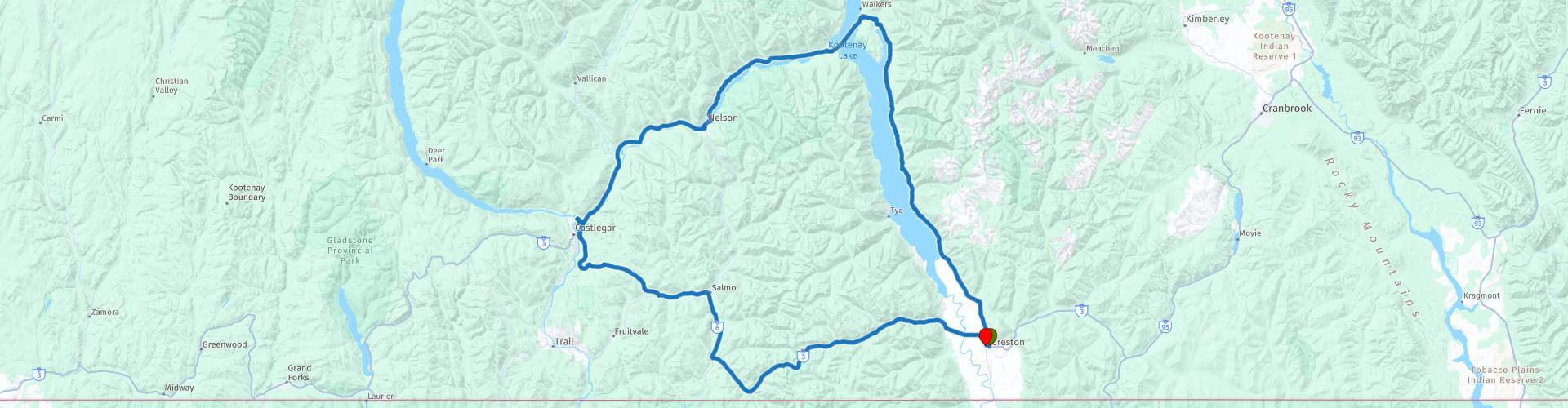
 This route through British Columbia largely follows the scenic and winding Highway BC-3A, a road that takes you past mountains, lakes, dams and various national parks.
You'll depart from Creston, where the BC-3A begins immediately. You'll enter Creston Valley, an area managed by the Creston Valley Wildlife Management Area to control invasive species in the wetlands, particularly cattails and reed canaries.
The BC-3A winds between the shores of Kootenay Lake and the mountains on your right. Through the trees, you'll frequently have stunning views of the lake and the Kootenay Mountains on the other side. There are several photo opportunities along the route, such as at Columbia Point.
You'll continue past Lockhart Creek Provincial Park, with small lakeside beaches and several campgrounds. Hiking, fishing, and hunting (seasonal) are available. There are also places to eat and drink along BC-3A.
We'll cross from Kootenay Bay to Balfour by ferry. This free crossing takes about 35 minutes and is the longest free ferry ride in the world. The view of Kootenay Lake and the surrounding mountains is spectacular.
Once you arrive in Balfour, you can have lunch at one of the small restaurants or snack bars. After lunch, we'll drive to Kokanee Creek Provincial Park, with three beautiful white beaches and forests offering plenty of privacy. Here you can plan some time to relax.
Continue along the Kootenay River towards Nelson and cross the river on the Nelson Bridge, also known as the Big Orange Bridge (BOB). This is the only bridge over the river near Nelson. You can take a photo from a small beach with a café, where you can also stop for a drink.
Besides the BOB we pass more bridges and dams in the Kootenay River, these are indicated with a waypoint;
The Corra Linn Dam: Built in 1932, 16 metres high, with three 19,000 hp turbines and a capacity of 51 MW.
The Brilliant Dam: WWII hydroelectric dam, 42.6 meters high with eight lock gates.
The Brilliant Suspension Bridge: A historic suspension bridge dating from 1913, it reopened in 2010 as a footbridge and was designated a national historic site. This bridge is clearly visible as we cross the river on the new bridge.
In the town of Castlegar we visit two interesting sights that are within walking distance of each other;
The Doukhobor Discovery Centre: Relive life in Southern BC (1908–1938) with exhibits and tours.
The Kootenay Gallery of Art, History and Science: Art gallery featuring regional, national, and international works, and a platform for local artists.
After these cultural stops, it's about 120 km back to Creston. Along the way, you can stop in Salmo, a village of about 1,140 people, known from the series "Gold Trails and Ghost Towns" (season 3, episode 1).
We drive back to Creston via the beautiful Kootenay Pass.


 Links
Links  Usage
Usage Want to download this route?
You can download the route for free without MyRoute-app account. To do so, open the route and click 'save as'. Want to edit this route?
No problem, start by opening the route. Follow the tutorial and create your personal MyRoute-app account. After registration, your trial starts automatically.  Disclaimer
Use of this GPS route is at your own expense and risk. The route has been carefully composed and checked by a MyRoute-app accredited RouteXpert for use on TomTom, Garmin and MyRoute-app Navigation.
Changes may nevertheless have occurred due to changed circumstances, road diversions or seasonal closures. We therefore recommend checking each route before use.
Preferably use the route track in your navigation system. More information about the use of MyRoute-app can be found on the website under 'Community' or 'Academy'.