Day 06 TCH Lake Louise to Calgary

This route was brought to you by:
RouteXpert René Plücken (MRA Master)
Last edit: 12-02-2021
 Route Summary
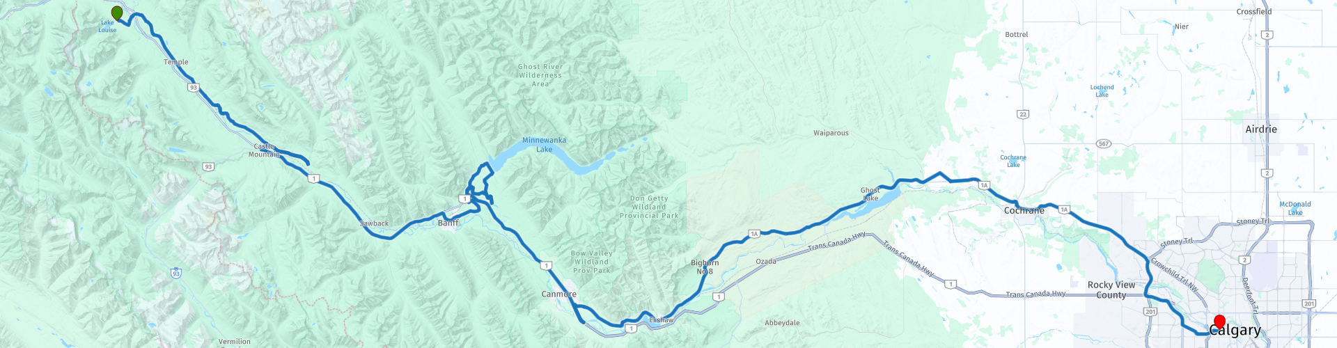
 This is part 6 that runs from Lake Louise to Calgary.
The Trans Canada Highway passes through all the southern provinces of the country. The route can be driven in different ways. There are namely in various alternative routes that also belong to the TCH. The total distance is around 8,000 km. We not only drive the TCH, but will take the rural roads as much as possible, because only highway driving is too boring and Canada has many beautiful roads through its beautiful landscape.
You drive through all provinces and through very varied and scenic landscapes, from the Rockies in the West, the Central Prairies to the Eastern Maritimes and the Northern Forest.
The riding season is generally April through October with longer seasons on the west coast and southern Ontario.
Provide good all season clothing or bring rain gear, depending on the province and the season the weather can change and you may be surprised by a rain or even a snow or hail shower, so be prepared.
In Canada the metric system is used, so speeds are indicated in Km / h. A helmet requirement (DOT approved) applies throughout Canada.
You will see many wildlife throughout Canada. your similar animals from province to province, such as deer, buffalos, moose, caribou, wolves, pumas, bears, mountain goats, sheep, lynx, coyotes, foxes, raccoons, badgers, various rodents and all kinds of birds.
Even if it is very tempting to stop for a photo, don't do it, it can be very dangerous.
 Share this route


Animation

Verdict


Duration
4h 16m

Mode of travel
Car or motorcycle

Distance
236.96 km

Countries

 RouteXpert Review
 Before we leave Lake Louise you can visit the visitors center (RP2) at RP2 for some extra info and maybe a souvenir. And refuel.
The original Trans Canada Highway starts at RP4, but as mentioned we take the AB-1A Bow Valley Parkway (start RP5), you MUST have driven this road between Banff and Lake Louise. This is a full day trip and will give you time to take nice pictures and visit beautiful sights, this ride will be engraved in your memory afterwards. If you have enough time and also want to hike one of the many Hike Trails, you can choose to ride this route in 2 days with an overnight stay in Banff.
Bow Valley Parkway meanders through the Canadian nature along the course of the Bow River. The vistas are truly breathtaking and there are several points along the way to stop and enjoy all the beauty. A number of points are included as RP and or POI, such as;
RP6 At Morant's Curve here you have a beautiful view of the mountains, Bow river and the Canadian Pacific railway where the heavy and long trains run long.
RP8 Johnston Canyon and Lower Falls. Here you can hike to the Johnston Canyon Trail and Lower Falls, it's a 1.5 mile hike through a canyon with a waterfall.
At RP9 we briefly turn onto the Trans Canada Highway to drive to Banff (RP10) where we stop for a delicious lunch in one of the many restaurants. Banff itself has a lot to offer, so a longer stop and overnight stay are definitely an option. You have several museums and a beautiful park along the river.
Leaving Banff we stop at RP11 and 12 for a photo stop at Hoodoos Viewpoint, you have a beautiful view of the mountains and river here, you can take a longer walk if you want to admire more of the scenery.
Before we turn onto the TCH we drive the Lake Minnewanka Scenic ride, this is a short tour with really beautiful panoramas. RP13 has a small harbor where you can take a boat trip. Along this scenic ride are a number of vantage points to safely stop for a photo. We also drive to Johnson Lake (RP14), again a beautiful mountain lake with a small park and a walking path around the lake.
We turn the TCH back to RP16 where we take the exit and drive up the Bow Valley Trail, this road is again enjoyable with curves and beautiful panoramas.
For dog lovers, the Yamnuska Wolfdog Sanctuary (RP20) is a must visit. This is a non-profit organization promoting responsible wolfhound ownership by offering various educational programs. They discuss the challenges of wolf dog ownership and outline what a suitable home looks like. They also discuss the importance of wolf conservation in the wild! In addition to the educational programs, the sanctuary also oversees the rescue and safe sanctuary for wolf dogs that have been neglected, abandoned, or otherwise moved.
After this stop we drive back to the route to drive to the terminus Calgary.
This route with its beautiful roads, nature, panoramas and beautiful sights is worth 5 ***** Stars.


 Links
Links  Usage
Usage Want to download this route?
You can download the route for free without MyRoute-app account. To do so, open the route and click 'save as'. Want to edit this route?
No problem, start by opening the route. Follow the tutorial and create your personal MyRoute-app account. After registration, your trial starts automatically.  Disclaimer
Use of this GPS route is at your own expense and risk. The route has been carefully composed and checked by a MyRoute-app accredited RouteXpert for use on TomTom, Garmin and MyRoute-app Navigation.
Changes may nevertheless have occurred due to changed circumstances, road diversions or seasonal closures. We therefore recommend checking each route before use.
Preferably use the route track in your navigation system. More information about the use of MyRoute-app can be found on the website under 'Community' or 'Academy'.