Cabot Trail Nova Scotia

Diese Route wurde erstellt von:
RouteXpert René Plücken (MRA Master)
Letzte Änderung: 11-10-2025
 Routenzusammenfassung
 Die Panoramen sind wunderschön und scheinen endlos.
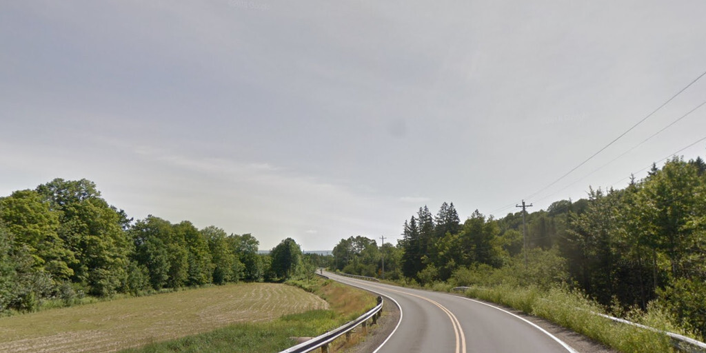
Die Straßen sind ausgezeichnet und gut gepflegt, meist zweispurig und kurvenreich.
Es gibt mehrere Möglichkeiten für Motorradtouren durch Kanada, individuell oder organisiert.
Lassen Sie sich von diesem wunderschönen Land überraschen.
Planen Sie Ihre Reise gut und berücksichtigen Sie das Klima.
Streckenbewertung: ★★★★★
Diese Tour bietet alles: beeindruckende Ausblicke, reiche Kultur, Wildtiere, Wandermöglichkeiten, Strände und charmante Dörfer. Ein absolutes Muss für Naturliebhaber und Abenteurer.
 Diese Route teilen


Animation

Urteil


Dauer
10h 11m

Reisemodus
Auto oder Motorrad

Entfernung
309.49 km

Länder

 RouteXpert-Überprüfung
 Die Route führt um die Nordspitze der Insel herum und durch das bretonische Hochland des Kaps. Sie ist nach dem Entdecker John Cabot benannt, der 1497 im atlantischen Kanada landete.
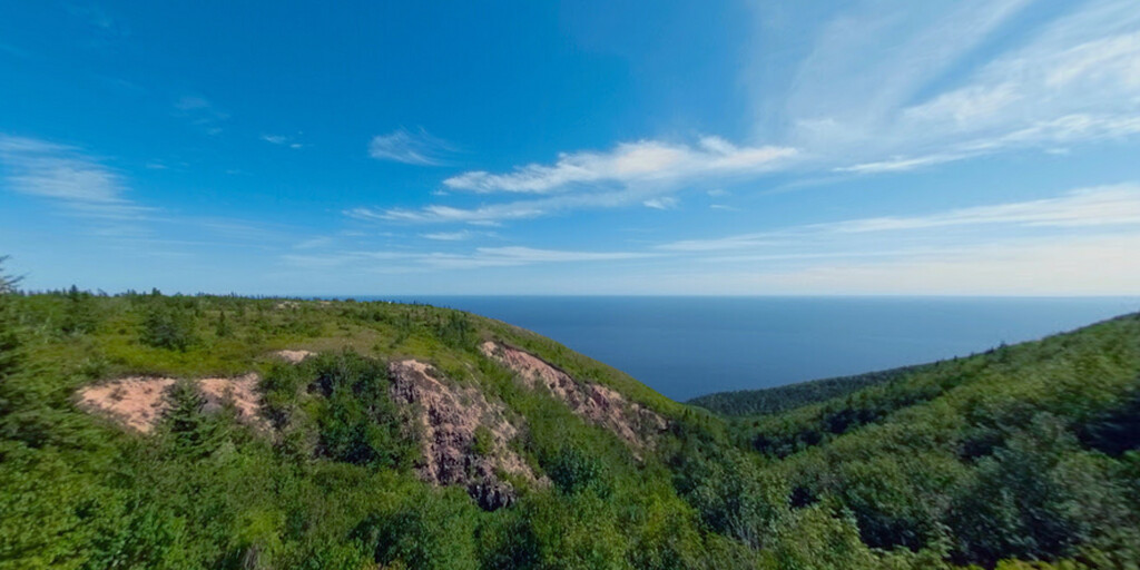
Der nördliche Abschnitt des Cabot Trails verläuft durch den Cape Breton Highlands Nationalpark. Die westlichen und östlichen Abschnitte folgen der zerklüfteten Küste und bieten Ausblicke auf das Meer. Der südwestliche Abschnitt führt durch das Margaree River Valley und anschließend am Bras d'Or Lake entlang.
Der Cabot Trail wurde vom Ministerium für Verkehr und öffentliche Arbeiten als Trunk 30 bezeichnet. Die Route ist ganzjährig geöffnet.
Sie fahren durch atemberaubende Landschaften, charmante Dörfer und die raue kanadische Wildnis mit ihren ausgedehnten Wäldern. Die Route verläuft größtenteils entlang der Küste und Sie können an mehreren Stellen Wale und Robben beobachten.
Die knapp 300 km lange Strecke lässt sich gut an einem Tag bewältigen, aufgrund der Schönheit empfiehlt es sich aber, sie zu einem mehrtägigen Ausflug auszudehnen. Auf der Insel gibt es mehrere Hotels, Campingplätze und B&Bs. Start und Ziel liegen kurz hinter Wagmatcook 1, wo der Trans Canada Highway in den Cabot Trail mündet. Einige Abschnitte dieser Straße sind ereignislos und gerade, sodass wir gelegentlich eine ländlichere Route wählen.
Der erste Halt, nur elf Kilometer entfernt, ist das Alexander Graham Bell Museum. Dieses Museum beherbergt Gegenstände, die 1955 aus dem Privatmuseum der Familie Bell gespendet wurden. Es gibt auch Erinnerungsstücke aus Bells Experimenten, darunter den Originalrumpf eines Tragflügelboots, der HD-4, das 1919 in Baddeck mit über 112 km/h einen Geschwindigkeitsweltrekord aufstellte.
Der nächste Halt auf der Route ist die Iron Art & Photographs Gallery. In dieser vielseitigen „Roadside Attraction“ präsentieren die Künstler Gordon und Dominique ihre einzigartigen Werke. Faszinierende Metallskulpturen werden vor Ort gefertigt; farbenfrohe Strickwaren und beeindruckende Fotografien werden ebenfalls angeboten.
Im „The Dancing Moose Cafe“ können Sie eine Kleinigkeit essen. Genießen Sie die Aussicht im Cape Smokey Provincial Park. Wanderfreunde können rechts abbiegen, zum Parkplatz fahren und (einen Teil) des Cape Smokey Trailheads wandern. Obwohl dieser Weg nicht gepflegt wird, ist er dennoch leicht zu begehen. Die Aussicht ist grandios und die Mühe wert, besonders wenn Sie an einem nebligen Morgen wandern, bevor ein sonniger, klarer Tag kommt. Lange Hosen sind aufgrund des dichten Buschwerks und der häufigen Umwege durch umgestürzte Bäume ein Muss.
Während unserer Fahrt durch den Cape-Breton-Nationalpark sollten Sie unbedingt am Ingonish Visitor Centre Halt machen. Die Mitarbeiter informieren Sie gerne über den Park und die Umgebung, helfen Ihnen bei der Orientierung, beim Kauf von Parkpässen und Programmtickets und informieren Sie über die neuesten Informationen zu den Einrichtungen und Aktivitäten des Parks. Offizielle Parks Canada-Artikel wie Hüte, T-Shirts, Kapuzenpullover und Regenschirme sind hier ebenfalls erhältlich. Auf der anderen Straßenseite können Sie über einen Wanderweg zum Freshwater Lake Lookout wandern, der einen atemberaubenden Blick auf den Freshwater Lake bietet.
Entlang des Cabot Trails gibt es mehrere Wanderwege, auf denen Sie den Cape-Breton-Nationalpark beim Wandern genießen können. Diese sind deutlich gekennzeichnet. Einige davon sind in der Übersicht als Wegpunkte und Sehenswürdigkeiten aufgeführt. Es gibt auch mehrere Aussichtspunkte entlang der Route, sodass Sie viele Möglichkeiten haben, anzuhalten und diesen wunderschönen Naturpark zu genießen. Für Wanderfreunde gibt es entlang der Küste auch mehrere schöne Strände. Bringen Sie also Badesachen und ein Handtuch mit.
Sie können den Green Cove Trail wandern. Obwohl es ein kurzer Spaziergang ist (eine gute Möglichkeit, sich die Beine zu vertreten), lohnt er sich auf jeden Fall, denn die Aussicht ist faszinierend. Von dieser felsigen Granitspitze, die ins Meer ragt, können Sie die Wellen beobachten, die gegen die Felsen schlagen, und vielleicht sogar einen Blick auf Wale vor der Küste erhaschen. Halten Sie Ausschau nach den verdrehten Bäumen, den sogenannten „Krummholz“. Die Pflanzen hier haben sich an die windige, salzige Küstenumgebung angepasst und haben ledrige Blätter.
Halten Sie am Neil's Harbour Lighthouse, einem der vielen typischen Leuchttürme Nova Scotias, die oft aus Holz in Rot und Weiß gebaut sind. In der Nähe des Leuchtturms gibt es auch ein kleines Restaurant. Anschließend verlassen Sie den Cabot Trail und fahren auf einer schmalen, kurvenreichen Straße in Richtung White Point, wo Sie über einen Pfad bis zur Spitze wandern können, der eine wunderschöne Aussicht bietet.
Wir halten am North Highlands Community Museum & Culture Centre, das die Geschichte und das Erbe von Northern Cape Breton präsentiert und als Treffpunkt der örtlichen Gemeinde dient, um die Geschichten und Talente unseres Volkes zu teilen.
Das Lone Shieling ist eine Hütte im schottischen Stil, die 1942 erbaut wurde. Sie können die Hütte von der Straße aus sehen, aber um sie zu besuchen, müssen Sie etwa 100 Meter fahren und parken, und dann ist es ein kurzer Spaziergang durch den Park.
Der nächste Halt ist Pleasent Bay, wo Walbeobachtungsbegeisterte die Gelegenheit nutzen können und zwischen mehreren Kreuzfahrtunternehmen wählen können.
Wir fahren entlang der Küste mit herrlichem Blick auf das Meer bis zur Margaree Bay. Anschließend folgen wir dem Lauf des Margaree River und fahren weiter entlang der Middle River Wilderness Area bis zum Ende dieser malerischen Fahrt.
Diese Tour bietet atemberaubende Ausblicke, interessante Sehenswürdigkeiten und eine wunderschöne, abwechslungsreiche Landschaft. Sie fahren durch Berge, Täler, entlang der Küste, durch Wälder und durch kleine Fischerdörfer. Entlang der Strecke gibt es viele kleine Restaurants, in denen Sie köstlich essen können, besonders wenn Sie Fisch mögen.
 Links
Links  Nutzung
 Möchten Sie diese Route herunterladen?
Sie können die Route ohne MyRoute-App-Konto kostenlos herunterladen. Öffnen Sie dazu die Route und klicken Sie auf 'Speichern unter'. Möchten Sie diese Route bearbeiten?
Kein Problem, starten Sie mit dem Öffnen der Route. Folgen Sie dem Tutorial und erstellen Sie Ihr persönliches MyRoute-App-Konto. Nach der Registrierung startet Ihre Testversion automatisch.  Haftungsausschluss
Die Nutzung dieser GPS-Route erfolgt auf eigene Kosten und Gefahr. Die Route wurde sorgfältig von einem MyRoute-App akkreditierten RouteXpert für die Verwendung mit TomTom, Garmin und MyRoute-App Navigation zusammengestellt und geprüft.
Durch geänderte Umstände, Straßenumleitungen oder saisonale Sperren können sich dennoch Änderungen ergeben haben. Wir empfehlen daher, jede Route vor der Nutzung zu überprüfen.
Verwenden Sie vorzugsweise den Routentrack in Ihrem Navigationssystem. Mehr Informationen zu den Die Nutzung der MyRoute-App finden Sie auf der Website unter 'Community' oder 'Academy'.

Neuschottland
Über diese Region
Nova Scotia [ˌnoʊvə ˈskoʊʃə] (lateinisch für Neuschottland, französisch Nouvelle-Écosse, schottisch-gälisch Alba Nuadh) ist eine der drei Seeprovinzen Kanadas. Sie liegt an der Atlantikküste und besteht zum größten Teil aus der gleichnamigen Halbinsel. Die Hauptstadt ist Halifax.
Lesen Sie mehr auf Wikipedia
Region anzeigen
 Statistik
  6
6Anzahl der RX-Bewertungen (Neuschottland)
 11617
11617Anzahl der Besucher (Neuschottland)
 273
273Anzahl der Downloads (Neuschottland)
 Routensammlungen in dieser Region
 Trans Canada Highway
Der Trans-Canada Highway (TCH) oder Trans-Canadian Highway ist ein Autobahnsystem, das alle 10 Provinzen Kanadas abdeckt.
Das Bundes- und Provinzautobahnsystem, das jetzt das TCH bildet, wurde durch das Trans-Canada Highway Act von 1948 genehmigt und 1962 eröffnet. Es wurde 1971 fertiggestellt. Die Gesamtlänge des TCH beträgt 7821 km.
Im Gegensatz zum amerikanischen Interstate Highway System besteht das TCH nicht aus einem eindeutigen Autobahnnetz, sondern aus einem Netz von Autobahnen mit beschränktem Zugang und anderen Hauptstrecken, die den niederländischen Provinzstraßen ähnlicher sind. Die Route wird durch einen grünen Schild mit einem weißen Ahornblatt angezeigt.
Die Nummerierung der Straßen, die Teil des TCH sind, ist die Domäne der Provinzen. Nur die westlichen Provinzen haben ihre Nummerierung angepasst und der TCH trägt dort die Bezeichnung Highway 1.
Die Hauptstrecke des TCH beginnt in Victoria in British Columbia und führt über Calgary und Regina nach Winnipeg. Von Winnipeg führt die Route nach Kenora in Ontario, wonach mehrere Abzweigungen durch Ontario nach Ottawa führen.
Weiter östlich führt die Route durch die Provinz Quebec über Montreal und Quebec unter anderem nach Moncton, New Brunswick. Dann fährt der TCH weiter nach Osten durch Nova Scotia, wo ein Zweig (über die Confederation Bridge) nach Prince Edward Island führt. Ein weiterer Abschnitt führt in der Hafenstadt Sydney zum Meer hinunter, wo eine Fähre nach Channel-Port aux Basques auf der Insel Neufundland fährt. Von dort führt die Route mehr als 900 km bis zur Provinzhauptstadt St. John's im äußersten Südosten der Insel.
Wir fahren nicht nur den TCH, sondern werden auch so viel wie möglich auf den Landstraßen fahren, da nur das Fahren auf der Autobahn zu langweilig ist und Kanada viele schöne Straßen durch seine wunderschöne Landschaft hat. Sie fahren durch alle Provinzen und durch sehr abwechslungsreiche und landschaftlich reizvolle Landschaften, von den Rocky Mountains im Westen, den Central Prairies bis zu den Eastern Maritimes und dem Northern Forest.
Die Reitsaison dauert in der Regel von April bis Oktober mit längeren Jahreszeiten an der Westküste und im Süden von Ontario. Stellen Sie gute Kleidung für die ganze Saison bereit oder bringen Sie Regenbekleidung mit, je nach Provinz und Jahreszeit kann sich das Wetter ändern und Sie werden möglicherweise von einem Regen oder sogar einer Schnee- oder Hageldusche überrascht. Seien Sie also vorbereitet.
In Kanada wird das metrische System verwendet, daher werden Geschwindigkeiten in km / h angegeben. In ganz Kanada gilt eine Helmanforderung (DOT-genehmigt).
Sie werden viele wild lebende Tiere in ganz Kanada sehen. Dies variiert von Provinz zu Provinz, wie Hirsche, Büffel, Elche, Karibu, Wölfe, Pumas, Bären, Bergziegen, Schafe, Luchse, Kojoten, Füchse, Waschbären, Dachs, verschiedene Nagetiere und alle Arten von Vögeln. Auch wenn es sehr verlockend ist, für ein Foto anzuhalten, tun Sie es nicht, es kann sehr gefährlich sein.
Die in dieser Überprüfung beschriebenen Routen weichen manchmal vom Trans Canada Highway ab und bringen die Gesamtlänge auf 9.300 Kilometer. Die Routen sind so angelegt, dass Sie durch die wunderschönen Teile Kanadas mit wirklich wunderschönen Panoramen und wunderschönen Sehenswürdigkeiten fahren. Dies unterscheidet sich von Museen, Parks bis hin zu historischen Punkten. Die Routen sind nicht zu lang, so dass Sie unterwegs Zeit haben, um Fotos und Sehenswürdigkeiten zu machen. Sie können die Etappen auch anders anordnen und kombinieren oder andere Routen hinzufügen, um Ihre Reise zu verkürzen oder zu verlängern. Die Routen sind mit einer Sternebewertung gekennzeichnet. Einige Routen sind weniger anspruchsvoll oder interessant, müssen jedoch zum nächsten Punkt gefahren werden, weshalb sie häufig eine niedrigere Bewertung haben.
In der Routenbeschreibung finden Sie weitere Details zu den Routen und den Sehenswürdigkeiten auf dem Weg. Diese Punkte sowie Hotels, Restaurants, Tankstellen usw. sind mit einem POI und manchmal auch mit einem Routenpunkt gekennzeichnet. In der Beschreibung finden Sie auch Links zu interessanten Websites und zu den Routen, die mit diesem Tag verbunden sind.
Die beschriebenen Routen sind;
Tag 01 TCH Sieg für Nanaimo
Tag 02 TCH Nanaimo zur Hoffnung
Tag 03 TCH Hoffnung auf Kamloops
Tag 04 TCH Kamloops nach Revelstoke
Tag 05 TCH Revelstoke nach Lake Louise
Tag 06 TCH Lake Louise nach Calgary
Tag 07 TCH Calgary zum Medizinhut
Tag 08 TCH Medizinhut zum Elchkiefer
Tag 09 TCH Moose Jaw nach Regina
Tag 10 TCH Regina nach Brandon
Tag 11 TCH Brandon nach Winnipeg
Tag 12 TCH Winnipeg nach Kenora
Tag 13 TCH Kenora nach Ignace
Tag 14 TCH Ignace nach Thunder Bay
Tag 15 TCH Thunder Bay zum Marathon
Tag 16 Thunder Bay nach Wawa
Tag 17 TCH Wawa nach Sault Ste Marie
Tag 18 TCH Sault Ste Marie nach Espanola
Tag 19 TCH Espanola nach Mattawa
Tag 20 TCH Mattawa nach Ottawa
Tag 21 TCH Ottawa nach Montreal
Tag 22 TCH Montreal nach Quebec
Tag 23 TCH Quebec nach Riviere du Loup
Tag 24 TCH Riviere du Loup nach Grand Falls
Tag 25 TCH Grand Falls nach Fredericton
Tag 26 TCH Fredericton nach Moncton
Tag 27 TCH Moncton nach Charlottetown
Tag 28 TCH Charlottetown nach Truro
Tag 29 TCH Truro nach North Sydney
Tag 30 TCH North Sydney nach Corner Brook
Tag 31 TCH Corner Brook nach Grand Falls
Tag 32 TCH Grand Falls nach Clarenville
Tag 33 TCH Clarenville nach St. John.
Viel Spaß beim Lesen der Bewertungen und Planen Ihres nächsten Road Trips.
Wenn Sie diese Reise gefahren sind, bin ich sehr gespannt auf Ihr Feedback!
Routensammlung anzeigen