MTG2 13 French Alpes Roundtrip Lake of Annecy and Semnoz

This route was brought to you by:
RouteXpert René Plücken (MRA Master)
Last edit: 03-05-2021
 Route Summary
 climate. It is not for nothing that you see so many motorcyclists there. My previous series of routes in France were based on the route descriptions from the Motortourgids France part 1 made by Bert Loorbach.
This route comes from Motortourgids France part 2 and the original name is "The Alps Directions 2: Lake Annecy and Semnoz".
In Motorbike guide France part 2 a difference has been made between approach routes and trips in a certain area. The approach routes can also be used in combination with the routes from Motortourgids France part 1
The routes are sometimes slightly adjusted based on the tips that Bert Loorbach gives in his description, or because of a different place to spend the night, or to achieve the minimum length of 2 hours for the MRA Library. For each route there is a more detailed description in the review, including options to stay overnight or places of interest en route, which are also indicated with a POI and if possible with a short description
The route is made suitable for Garmin, TomTom, Harley-Davidson BoomBox 2019 and Navigation App, can be downloaded for free and without My-Route-app registration. To do this, first click on the 'Use route' button and then on 'Save as'.
 Share this route


Animation

Verdict


Duration
2h 27m

Mode of travel
Car or motorcycle

Distance
102.61 km

Countries

 RouteXpert Review
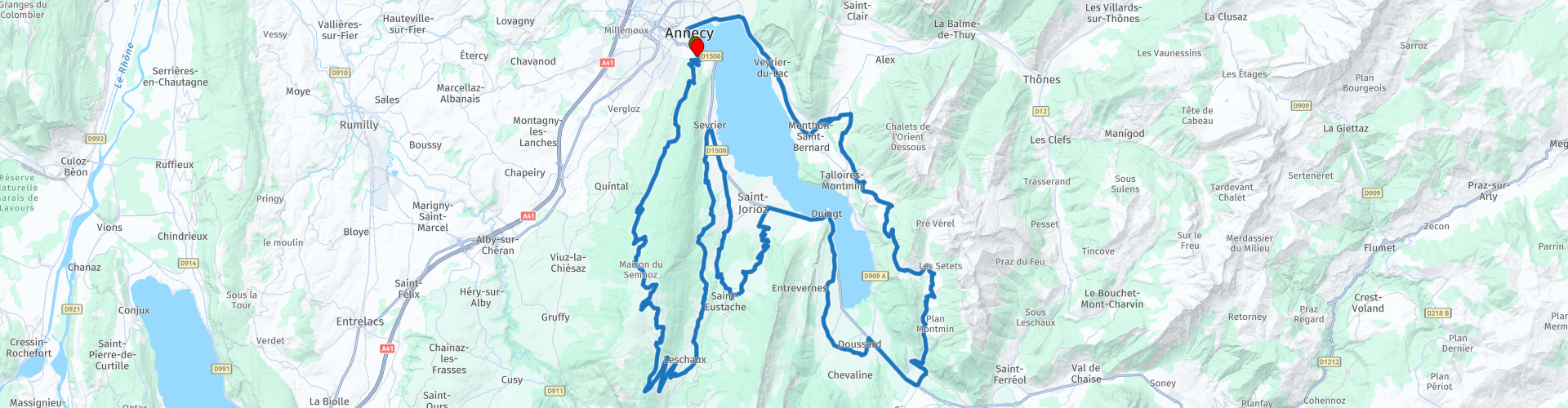
 The original route is a tour around Lake Annecy. We take a few extra kilometers on the beautiful narrow and very winding mountain roads that lie on the route. Also from these roads you occasionally have a beautiful view of the mountains and the lake.
We start from the Camping Municipal du Belvédère, we ride along the beautiful boulevard of Annecy along the azure blue. The route goes along the water towards Veyrier and Menthon Saint Benrard, here we visit the Château de Menthon-Saint-Bernard (RP5), which overlooks the turquoise waters of Lake Annecy. This castle has been redesigned and rebuilt over the years in the most romantic style. A legend says that it gave Walt Disney the inspiration for Sleeping Beauty Castle. This architectural jewel from Savoy is also a house that has been inhabited by the same family for over 1000 years. The Menthon family welcomes you for a visit. At the castle you have an even better view of the lake from the terrace.
We continue on the D169 to Ermitage-de-St. Germain, here is a small church and caves, to visit these you have to turn left at RP8 on the D42 and drive back up.
After this place of pilgrimage, the road starts to rise sharply and at 1157 meters you reach the
Col de la Forclaz (RP10). This is a nice place to take a break, here is a small restaurant souvenir shop and you have a beautiful view of Lake Annecy. For the dare devils there is also the possibility to paraglide and get an even better view of the mountains and the lake.
After this, the road goes down steeply with slope percentages of 13 to 15% and many beautiful curves, including hairpin curves.
At Vesonne (RP12) we turn on the N508, which returns to Annecy along the water. We drive a little in via Doussard and Chaparon to Duingt (RP15), this is a beautiful old town with a castle on a peninsula.
The original route goes from here on the D1508 along the lake to Sévrier, but we take the D10B just before Saint Jorioz at the roundabout and drive up a narrow, very winding road through the woods and then via a loop to drive down to the D1508 and at Sévrier take the D912, it goes immediately enthusiastically and right south again into the wooded area of the Semnoz.
Shortly after the Col de Leschaux (RP22) the D110 turns right (RP23) towards Crêt de Châtillon with immediately a couple of delightful hairpin bends at the start of a twelve kilometer long winding route with one of the most beautiful views of the Alps, just about none 1700 meters altitude. Then the road descends through the pine forests to get back to Annecy.
A beautiful ride that is certainly worth 4 **** stars because of the beautiful roads and panoramas. Along the way there is possibility to stop for a break to have something to drink and eat.


 Links
Links  Usage
Usage Want to download this route?
You can download the route for free without MyRoute-app account. To do so, open the route and click 'save as'. Want to edit this route?
No problem, start by opening the route. Follow the tutorial and create your personal MyRoute-app account. After registration, your trial starts automatically.  Disclaimer
Use of this GPS route is at your own expense and risk. The route has been carefully composed and checked by a MyRoute-app accredited RouteXpert for use on TomTom, Garmin and MyRoute-app Navigation.
Changes may nevertheless have occurred due to changed circumstances, road diversions or seasonal closures. We therefore recommend checking each route before use.
Preferably use the route track in your navigation system. More information about the use of MyRoute-app can be found on the website under 'Community' or 'Academy'.

Auvergne Rhone Alpes
About this region
Auvergne-Rhône-Alpes (ARA; French: [ovɛʁɲ ʁon‿alp] (listen); Arpitan: Ôvèrgne-Rôno-Ârpes; Occitan: Auvèrnhe Ròse Aups; Italian: Alvernia-Rodano-Alpi) is a region in southeast-central France created by the 2014 territorial reform of French regions; it resulted from the merger of Auvergne and Rhône-Alpes. The new region came into effect on 1 January 2016, after the regional elections in December 2015.The region covers an area of 69,711 km2 (26,916 sq mi), making it the third largest in metropolitan France; it had a population of 7,948,287 in 2017, second to Île-de-France. It consists of twelve departments and one territorial collectivity (Lyon Metropolis) with Lyon as the prefecture.
This new region combines diverse geographical, sociological, economic and cultural regions, which was already true of Rhône-Alpes, as well as Auvergne, to a lesser extent. While the old Rhône-Alpes and Auvergne regions each enjoyed a unity defined by axes of communication and the pull of their respective metropoles, the new combination is heterogeneous; it sustained lively opposition from some local officials after its creation.
Read more on Wikipedia
This new region combines diverse geographical, sociological, economic and cultural regions, which was already true of Rhône-Alpes, as well as Auvergne, to a lesser extent. While the old Rhône-Alpes and Auvergne regions each enjoyed a unity defined by axes of communication and the pull of their respective metropoles, the new combination is heterogeneous; it sustained lively opposition from some local officials after its creation.
View region
 Statistics
  100
100Amount of RX reviews (Auvergne Rhone Alpes)
 39482
39482Amount of visitors (Auvergne Rhone Alpes)
 5035
5035Amount of downloads (Auvergne Rhone Alpes)
 Route Collections in this region
 The 24 Most Beautiful Alpine Routes
The Alps, The Alps are a mountain range in Europe, stretching from the French Mediterranean coast in the southwest to the Pannonian Plain in the east. The area of the mountain range is more than 200,000 km².
In other words Passes and Mountain Roads!
Driving through the mountains is great! Especially over the mountain passes with hairpin bends and narrow winding roads. Every bend a different view where you can enjoy. There are many beautiful mountain passes in the Alps.
A selection that has also been incorporated into these routes:
The Stlevio Pass:
The Stelvio Pass, also known as Passo dello Stelvio, is mainly known for the stage in the Giro d'Italia. Due to the length and the difference in height, this pass is seen as one of the toughest tests in cycling. The Stelvio Pass reaches a maximum height of 2758 meters and is therefore one of the highest in the Alps. The pass connects the towns of Bormio and Prato Allo Stelvio. In winter the pass is closed due to heavy snowfall.
The Reschenpass:
The Reschenpass, also known as Passo di Resia, connects the Austrian state of Tyrol with the Italian province of South Tyrol. The pass reaches a maximum height of 1,504 meters and has been one of the most important north-south connections in the Alps in recent centuries. The pass was used long before Roman times. Along the way you will pass several highlights and historical relics. One of the highlights is the Reschensee. This lake was created after the construction of the dam and has completely submerged the village of Graun. The only thing that reminds of that is the clock tower in the middle of the lake.
Col du Galibier:
The French mountain pass Col du Galibier connects the towns of Saint-Michel-de-Maurienne and Briançon via the Col du Lautaret in the south and the Col du Télégraphe in the north. The mountain pass is part of the Tour de France and very much feared, due to the fact that it can only be reached via the other two mountain passes. The pass reaches a maximum height of 2646 meters. From there you can take a walk to the viewpoint at 2704 meters. You can admire the peaks of the Grand Galibier, Mont Blanc and La Meije here.
The Grossglockner High Alpine Road:
With a height of 3798 meters the Grossglockner is the highest mountain in Austria. To fully enjoy this impressive mountain, you can drive over the Grossglockner High Alpine Road and the accompanying pass. The route starts from Bruck am Grossglockner and ends in Heiligenblut. Of course you can drive in two directions. The pass reaches a maximum height of 2504 meters and is closed in winter due to heavy snowfall. Along the way you pass several stops with fun activities, information points, mountain huts and viewpoints. A visit to the Kaiser-Franz-Josefs-Höhe and Pasterzen Glacier is highly recommended.
The Col d'Izoard:
Just like the Col du Galibier, the Col d'Izoard is also part of a stage of the Tour de France. The mountain pass connects Briançon with the valley of the river Guil. The pass is partly located in the Regional Natural Park du Queyras and reaches a maximum height of 2360 meters. What is special about the Col d'Izoard is the barren and rocky landscape. Sometimes it feels like driving a car over the moon! Along the way you can stop at several points to enjoy the beautiful view.
The Bernina Pass:
The Bernina Express is one of the most famous rail trains in Switzerland and the Alps. The route is beautiful and partly included on the UNESCO World Heritage List. Parallel to the railway lies the Bernina pass, which connects the Veltlin valley with the Egandin valley. This beautiful Alpine road has a total length of 56 kilometers and reaches a maximum height of 2328 meters. Along the way you can enjoy views of the Morteratsch Glacier.
The Sella Pass:
The Sella Pass, also known as Passo di Sella, takes you over one of the most impressive mountain ranges in the Dolomites: the Sella massif. The pass connects Valle di Fassa with Val Gardena and reaches a maximum height of 2236 meters. At this height is also the border of the Italian provinces of Trentino and Bolzano. Along the way you can enjoy the view of this spectacular mountain world. Admire, for example, the three peaks of the Sasso Lungo massif, the Sella massif or the peaks of the Marmolada. You can also drive the Sella pass in combination with the Gardena pass, Pordoi pass and Campolongo pass.
The Grimsel Pass:
The Grimsel Pass connects Goms in Wallis with the Halis Valley in the Bernese Oberland. The pass reaches a maximum elevation of 2165 meters and is closed in winter due to snowfall. Over the centuries, the mountain pass has played an important role in trade between Switzerland and Italy. Now it is mainly the reservoirs that have an important function. These are used to generate electricity. The landscape you drive through is rugged, rocky and impressive. On top of the pass is a hotel and a restaurant with a special marmot park. The Dodensee (Totensee) is also located here. This lake owes its name to the many soldiers who died in the time of Napoleon.
The Gotthard Pass:
The Gotthard Pass, also known as Passo del San Gottardo and Saint Gotthard, connects the Swiss towns of Airolo and Andermatt. The mountain pass and associated tunnel are especially known among holidaymakers driving from Switzerland to Italy. But where the majority opt for the tunnel, it is precisely the pass that really completes the holiday. The Gotthard Pass has a length of about 26 kilometers and reaches a maximum height of 2106 meters. The route is beautiful and takes you along old villages and beautiful views.
The Silvretta High Alpine Road and Silvretta Pass:
The Paznaun Valley in Tyrol and the Montafon in Vorarlberg are connected by the Silvretta High Alpine Road. The route has a length of 22.3 kilometers and leads from Galtür to Partenen in 34 hairpin bends, via the 2032 meter high Bielerhöhe. The Silvrettasee is also located at this point, where you can enjoy a lovely walk. The pass is closed in winter due to snowfall.
The Simplon Pass:
Just like the Gotthard Pass, many holidaymakers also travel over the Simplon Pass every year. This mountain pass connects the Rhone Valley in the canton of Valais with the Valle d'Ossola in Piemonte. The pass is open all year round and reaches a maximum height of 2005 meters. Along the way you pass a number of buildings, including the well-known Simplon Hospiz from 1825. The hospiz is managed by the monks of St. Bernard. From the highest point on the pass, all kinds of hiking routes are possible and you will also come across a hotel where you can spend the night.
The Gerlos Pass:
The Gerlos Pass connects the Salzach Valley in the Salzburgerland with the Zillertal Valley in Tyrol. The pass is part of the Gerlos Alpenstraße and runs right through the Hohe Tauern National Park. Along the way you can enjoy beautiful views of the surroundings. The pass has a length of 12 kilometers and reaches a maximum height of 1531 meters. A ride over the Gerlos Pass can be ideally combined with a visit to the Krimmler Wasserfälle.
The Great St. Bernard Pass:
The Great St. Bernard Pass, better known as Col du Grand Saint Bernard, connects the Italian province of Valle d'Aosta with the Swiss canton of Valais. The pass is one of the highest in Switzerland and reaches a maximum height of 2469 meters. Like a number of other mountain passes in this list, the Great St. Bernard Pass has also been used as a connecting road for centuries. The pass is named after the St. Bernard dogs that used to help stranded travelers along with the monks. The pass is closed in winter.
The Timmelsjoch High Alpine Road:
The Timmelsjoch High Alpine Road connects the towns of Sölden in the Ötztal and Meran in South Tyrol. Tolls must be paid on the Hochgurgl - Moos route. Via a mountain road with about 60 hairpin bends you drive through a beautiful mountain world. With the Timmelsjoch Experience you can learn more about the history, the road and the environment via various stations. You can also visit the Top Mountain Crosspoint museum.
Col de l'Iseran:
With a maximum pass height of 2770 meters, the Col l'Iséran is one of the highest mountain passes in the Alps. The pass connects Bourg-Saint-Maurice with Bonneval-sur-Arc. Via a road full of hairpin bends you pass, among other things, Val-d'Isère and a side valley of the Maurienne that lies entirely in the National Park de la Vanoise. You can spot animals such as marmots and chamois and there is also a restaurant with a chapel on top of the pass.
The Gavia Pass:
The Gavia Pass (Italian Passo di Gavia) is a mountain pass in the Italian Alps, in the Lombardy region.
It is one of the highest pass roads in Europe. The road leads through the unspoilt Stelvio National Park. The road was built in the First World War to supply Italian soldiers who fought in the Italian-Austrian border area. The pass height is one of the most beautiful in the Alps. Here is the large Lago Bianco with, to the north, the mountain San Matteo (3684 meters). Lago Nero is slightly lower on the south side of the pass. Here the mountain group of the Adamello determines the view. There are many well-marked walks in the area. During the winter the pass is closed due to the heavy snowfall. The pass is often closed until May and June due to the large amount of snow.
Promoter has made a selection of the 24 Most Beautiful Alpine routes that they have set out in recent years.
The routes go through:
France
Austria
Switzerland
Italy
The most beautiful roads, the most beautiful views, the most beautiful viewpoints. The highest mountains, the fastest descents, hairpin bend after hairpin bend, you name it you can't get enough of it.
If you go on holiday in this region, take advantage of it, ALL routes in this collection have been checked and made equal for TomTom, Garmin and MyRoute-app Navigation by a MyRoute-app RouteXpert.
Have fun with this collection and while driving one of these routes. Enjoy all the beauty that the Alps and the Dolomites have to offer. Click on “View route” to read the review of the chosen route.
I would like to hear your findings about the route(s).
View Route Collection
25 Magnificent trails in France
This MRA route collection contains 25 beautiful motorcycle routes in different parts of France, such as the Ardennes, the Alsace, Vercors, the Drôme, the Ardèche, Cote d'Azure, Gorges du Verdon, the Ariège, the Dordogne and Brittany.
The routes have been carefully created by Bert Loorbach, who is an enthusiastic motorcyclist himself. He lived in France for a year and a half, during which time he devoted himself to mapping the unknown and beautiful back roads of France especially for motorcyclists.
The routes are bundled in the Motortourgids France part 1 of Kosmos publishing house and now also available in MyRouteApp.
I have taken over the routes in MRA and sometimes adjusted them slightly to make them even more interesting for the motorcyclist.
View Route Collection