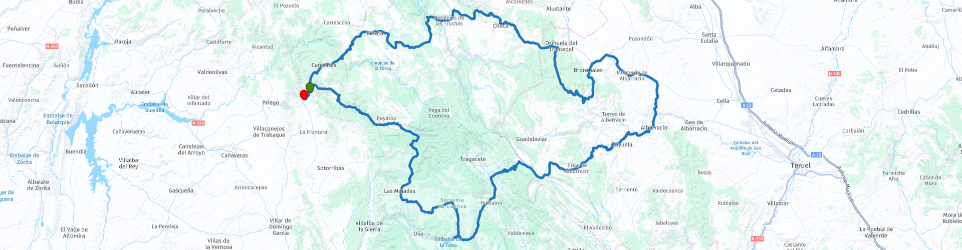
Albarracin is the dream

This route was brought to you by:
RouteXpert b0hd1
Last edit: 08-05-2023
 Route Summary
 Incredible secondary roads in the Majadas area that should not be missed.
Route suitable for experienced pilots due to complicated sections.
5-star route through its landscapes, roads and the beautiful and historic city of Albarracin
 Share this route


Animation

Verdict


Duration
7h 10m

Mode of travel
Car or motorcycle

Distance
277.54 km

Countries

 RouteXpert Review
 Albarracín is a unique place. Walking through its streets, exploring its walls and exploring its monuments is like taking a trip to the Middle Ages. Admire every corner, its reddish-colored houses, its doors and knockers, its tiny windows with lace curtains or its continuous balconies in rich wrought iron and carved wood.
The precious architectural and urban legacy of Albarracín exudes charm and calm. Not to mention the wonderful views you'll get from its enviable location.
The Plaza Mayor, where the Town Hall is located, is a good place to start your visit to this picturesque town, which is home to a number of interesting monuments and museums, such as the cathedral, the churches of Santiago and Santa María, the Casa- Noble Museum of the Pérez and Toyuela family, the Municipal Museum and the Diocesan Museum. Not to be missed if you go with children is the Toy Museum.
To enjoy the natural surroundings of Albarracín, you can take a pleasant walk along the Guadalaviar River and walk along the river promenade next to the meander dug by the river as it passes through the town.
It is advisable to use the car parks at the entrance to the town and wear comfortable shoes to avoid the many slopes and stairs that you will find during your tour of Albarracín.
Another of the attractions that Albarracín offers is the Dinópolis Territory branch dedicated to the world of fossils and prehistoric seas: Mar Nummus.
In its surroundings lies one of the most amazing landscape and cultural complexes in Aragon: the Protected Landscape of the Rodeno Pine Forests. The chromatic contrasts between the green of the pine forest and the red of the rodeno stone create a space of great colour, strength and beauty. In its rock shelters excellent samples of Levantine rock art are preserved, declared a World Heritage Site by UNESCO.
The best way to get to know Albarracín is, without a doubt, enjoying a guided tour through its streets and its most emblematic monuments. They are organized by the Santa María Foundation and also by the tourist services company El Andador.
TAJO RIVER SOURCE
The Tagus River, the longest in the Iberian Peninsula with 1008 kilometers in length, is born at this point in the Montes Universales, called Fuente García. This river, which we see here as a small stream, finally flows into the city of Lisbon, with an average flow of 444 m3 per second.
Very close to where the river actually starts, a little lower, going along the road between Guadalaviar and Frías de Albarracín, we find the monument to the river Tagus River, in which we can see a huge statue that represents the personification of the river , and the symbols of the provinces of Teruel (the bull with the star), Guadalajara (the knight) and Cuenca (the chalice).
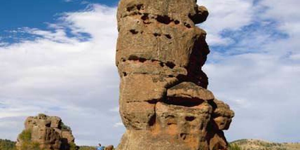
CHEQUILLA MONOLITHS
Chequilla is a Spanish municipality belonging to the province of Guadalajara, in the autonomous community of Castilla-La Mancha. The municipality is located in the Alto Tajo Natural Park, in the valley of the Cabrillas River. However, it corresponds to the Señorío de Molina de Aragón. In 2015 it had a population of 21 inhabitants. Chequilla stands out for its red sandstone rock formations.
GATES OF HELL
Curious tunnels in the rock that were created by the action of the rivers.

 Links
Links  Usage
Usage Want to download this route?
You can download the route for free without MyRoute-app account. To do so, open the route and click 'save as'. Want to edit this route?
No problem, start by opening the route. Follow the tutorial and create your personal MyRoute-app account. After registration, your trial starts automatically.  Disclaimer
Use of this GPS route is at your own expense and risk. The route has been carefully composed and checked by a MyRoute-app accredited RouteXpert for use on TomTom, Garmin and MyRoute-app Navigation.
Changes may nevertheless have occurred due to changed circumstances, road diversions or seasonal closures. We therefore recommend checking each route before use.
Preferably use the route track in your navigation system. More information about the use of MyRoute-app can be found on the website under 'Community' or 'Academy'.

Castilla–La Mancha
About this region
Castilla–La Mancha (UK: , US: , Spanish: [kasˈtiʎa la ˈmantʃa] (listen)), or Castile La Mancha, is an autonomous community of Spain. Comprising the provinces of Albacete, Ciudad Real, Cuenca, Guadalajara and Toledo, it was created in 1982. The government headquarters are in Toledo.
The region largely occupies the southern half of the Iberian Peninsula's Inner Plateau, including large parts of the catchment areas of the Tagus, the Guadiana and the Júcar, while the northeastern relief comprises the Sistema Ibérico mountain massif.
It is bordered by Castile and León, Madrid, Aragon, Valencia, Murcia, Andalusia, and Extremadura. It is one of the most sparsely populated of Spain's regions. Albacete, Guadalajara, Toledo, Talavera de la Reina and Ciudad Real concentrate the largest urban areas in the region.
Read more on Wikipedia
The region largely occupies the southern half of the Iberian Peninsula's Inner Plateau, including large parts of the catchment areas of the Tagus, the Guadiana and the Júcar, while the northeastern relief comprises the Sistema Ibérico mountain massif.
It is bordered by Castile and León, Madrid, Aragon, Valencia, Murcia, Andalusia, and Extremadura. It is one of the most sparsely populated of Spain's regions. Albacete, Guadalajara, Toledo, Talavera de la Reina and Ciudad Real concentrate the largest urban areas in the region.
View region
 Statistics
  13
13Amount of RX reviews (Castilla–La Mancha)
 13485
13485Amount of visitors (Castilla–La Mancha)
 487
487Amount of downloads (Castilla–La Mancha)
 Route Collections in this region
 A 4 day tour in Spain from Bilbao to Cartagena
With a starting point just south of Bilbao, this 1,300 km tour is easy to connect to from the French border or Santander. The tour travels through some of Spain's most spectacular landscapes and visits among other things, the windmills of La Mancha, made famous in the books by Miguel de Cervantes and his character Don Quixote. The end of this 4 day tour is at Cartagena on the Mediterranean's Costa Cálida, a wonderful city that's alive with culture, history and gastronomy.
View Route Collection
A 5-day tour from Peniscola visiting Toledo Merida Avila Segovia Siquenza Barcelona
A 5-route, 5-day tour of Peniscola, Aranjuez, Toledo, Consuegra, Molinos, Merida, Avila, Segovia, seguiranza and Barcelona, taking in these sites will immerse you in the rich history and culture of Spain. From stunning medieval fortresses to charming windmill villages, you will pass through picturesque roads enjoying the exquisite local cuisine and natural beauty that each place has to offer. It will be an unforgettable experience full of discoveries and unforgettable moments. Definitely a trip worth taking!
View Route Collection