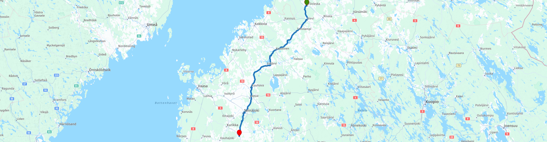
R22 Ylivieska to Jalasjarvi

This route was brought to you by:
RouteXpert Arno van Lochem - RouteXpert
Last edit: 20-05-2021
 Route Summary
 The routes are easy for everyone to drive and are on well-paved roads. It may be necessary to take a single hairpin bend, but these are perfectly doable.
If there is a piece of gravel in the route, a warning will be given and, if possible, a detour will be indicated.
The route starts in Ylivieska, located in North Ostrobotnie. Along the way fantastic landscapes, lots of water, forest and beautiful views through which the road winds wonderfully. Nice to drive. After every turn a different fantastic view. Beautiful and interesting sights include two places where you have a beautiful view over Lake Evijärvi, the old wooden church of Sievi and the textile and knife museum.
Beautiful rugged landscape, beautiful scenic views, tight roads and beautiful sights, hence the 4-star rating.
 Share this route


Animation

Verdict


Duration
6h 38m

Mode of travel
Car or motorcycle

Distance
235.99 km

Countries

 RouteXpert Review
 Of all western European countries, the Scandinavian countries probably have the most more or less untouched nature. In addition, they are countries that are easily accessible from the Netherlands. Norway is characterized by, among other things, the fjords and the Trollstigen known to many motorcyclists. And where Sweden is known as wide and peaceful, everyone knows Finland as the land of 1000 lakes. All in all, legitimate reasons to traverse this beautiful nature in the north of Europe by means of a number of routes.
After having visited the great highlights of this tour, you will also descend further south in this route. The route starts in Ylivieska. This is a town near the border of Central and North Ostrobothnia. Ylivieska is a city that grew up at the crossroads of railways, on the banks of the Kalajoki River. The city has over 15,000 inhabitants and an area of over 573 km². a place with over 20,000 inhabitants, located on the Gulf of Bothnia.
Shortly after the start you will pass a gas station where you can fill the tank if necessary. You can also buy some food and drinks in the shop for on the go. Although there is a reasonable opportunity to stop for food and / or drinks along the way, you will occasionally drive through areas where it is less populated.
After about 25 kilometers you will pass an old wooden church in Sievi. It is the fourth church in this town. In 1650 the parish of Sievi was separated from the parish of Kalajoki in its own chapel parish called Evijärvi. The first church was built in 1654 near the current Oude Kerkdorp. However, the church turned out to be too small and therefore a new, larger church was built on the same site in 1690. This church was replaced by a church built by Simon Silvén, which was completed in 1775.
The village of Rautio separated from the parish of Sievi in 1826 in its own chapel parish. Earlier the villagers had built their own church. The separation of the village of Rauti from the parish of Sievi led to the construction of a new church in a new site closer to the center of the new parish area.
The new and thus the current church building was designed by the provincial architect of the province of Oulu, LI Lindqvist. The church, a traditional wooden cross-shaped church, was completed in 1861 and consecrated on June 30, 1862. The church is 46 meters long and the church tower is 36.5 meters high, in its original form the church is quite well preserved. The 1979 exterior painting attempted to restore the church's original color. Nice to stop and have a look.
After the coffee break in Kaustinen you will pass by Lake Evijärvi. Evijärvi is a lake in the municipality of the same name in the south of Ostrobothnia. It is part of the Ähtäväjoki catchment area and is located in the middle of the river below Lappajärvi, the central lake in the catchment area. The lake has an area of 28 km² and a maximum depth of 4.2 meters. The water quality in the lake is good. The most common types of fish are perch, pike and bream. No wonder the lake is heavily fished by the locals and the fishing holidaymaker. Make no mistake about the number of tourists who visit these areas especially to cast a fishing line.
There are two places indicated in the route where you have a pleasant view over this lake.
Once in Kauhava it is time to enjoy lunch. This is possible in one of the many restaurants around the indicated parking lot. After lunch you can take a look at the textile and knife museum. In this museum you can view the different stages that textiles have gone through. The renowned history of bucket weaving is presented in an extensive textile collection.
In addition, they have an extensive knife collection, which includes even the oldest rarities. Among other things, you can see rarities ordered in 1901 from the Jauhava knife factory, a beautiful three-headed counselor with artful carvings.
A coffee break is planned shortly after the refueling stop in Seinajoki. You may want to consider visiting the Conservation and Lottery Museum after this coffee break. This is a special military history museum belonging to the Southern Ostrobothnia Provincial Museum in the center of Seinäjoki. The museum's activities are supported by the Support Association of the Finnish Guard and Lotta Svärd Museum.
The museum operates in the Seinäjoki Conservation Hall, designed by Alvar Aalto and built between 1924 and 1926, which housed the headquarters of the Southern Ostrobothnia Conservation District and the Lotta Svärd organization until 1944. After the wars, the house was used for a long time by the youth association and, for example, as premises for the tourist office of the city of Seinäjoki and the Summer University.
A few kilometers further you will pass the Museum of South East Robotnie. The Liinamaa farm and the 'Paapantupa', where the seniors of a family lived, together with the surrounding buildings form a typical South Ostrobothnic yard with its cowshed, drying shed, workshop, barn and sauna building.
Close to the wharf is also a windmill, a village shop from the 1890s and 'Propeeri', the laboratory of the gunpowder factory from 1826. In addition, the museum uses a number of former outbuildings of the manor, such as two pink 'Punatulkku'. '(bullfinch) buildings, including a museum pharmacy, dressmaking, watchmaker and blacksmith shop, knife workshop and exhibition, and apartments.
The manor's old stone cowshed contains the exhibition 'Mihinä me ollahan?' as well as a space for changing exhibitions, museum information desk, museum shop, café and a workshop. The old dairy building houses the Geo exhibition on the geology of the province and a museum about the nature of the area.
The route ends at hotel Jalaskievari. A nice hotel with a good review, with a sauna for a reasonable price.
For campers there are two camping sites in the area (20 km away!) From the end point: Pitkämönranta and Isosaaren leirikeskus
Have fun driving this route!


 Links
Links  Usage
Usage Want to download this route?
You can download the route for free without MyRoute-app account. To do so, open the route and click 'save as'. Want to edit this route?
No problem, start by opening the route. Follow the tutorial and create your personal MyRoute-app account. After registration, your trial starts automatically.  Disclaimer
Use of this GPS route is at your own expense and risk. The route has been carefully composed and checked by a MyRoute-app accredited RouteXpert for use on TomTom, Garmin and MyRoute-app Navigation.
Changes may nevertheless have occurred due to changed circumstances, road diversions or seasonal closures. We therefore recommend checking each route before use.
Preferably use the route track in your navigation system. More information about the use of MyRoute-app can be found on the website under 'Community' or 'Academy'.