Trappisten proeven in de Ardennen

This route was brought to you by:
RouteXpert Stijn Claus
Last edit: 27-06-2021
 Route Summary
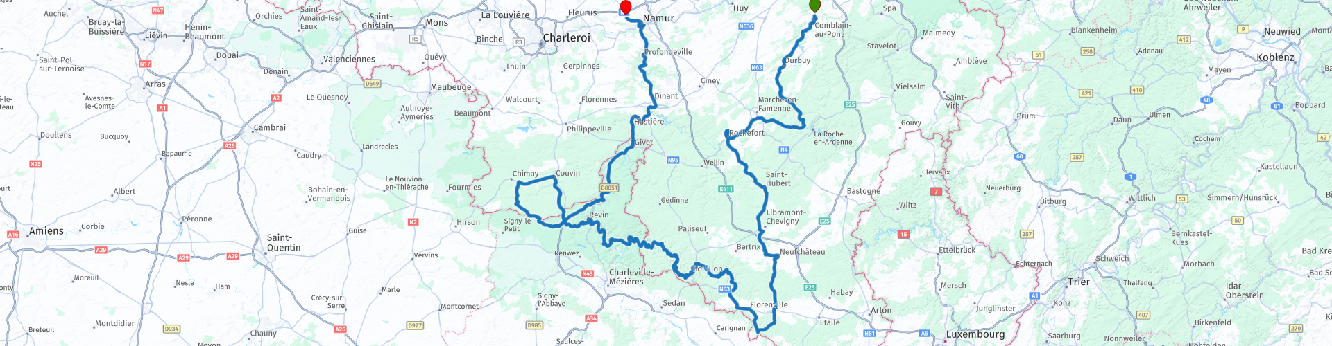
 On the way we also visit the cities of Durbuy, Bouillon and Dinant.
This route can be driven on a day or on several days. However, to fully enjoy the sights on the way, it's best to take two days for this trip.
The route can be split up according to your wishes, there are more than enough accommodation options along the way.
The route mainly follows the banks of the Ourthe and the Meuse. We follow secondary roads, but also much smaller roads. The cornering in this route in more than average. The quality of the road varies, as is often the case in the Ardennes from good to bad.
 Share this route


Animation

Verdict


Duration
7h 52m

Mode of travel
Car or motorcycle

Distance
443.03 km

Countries


 RouteXpert Review
 Along the banks of the Ourthe, Durbuy, La Roche and Marche and Famenne we arrive in Rochefort. Here lies the Abbey Notre-Dame de Saint-Rémy, or the Abbey of Rochefort.
The Notre-Dame de Saint-Rémy Abbey in Rochefort belongs to the Cistercians of the strict observance, better known as the Trappists. The foundation deed was granted in 1230 and the abbey was named Secours de Notre-Dame.
In 1899 they established a small brewery. The brewery became the main source of income for the abbey.
Rochefort is one of the abbeys that can use the name 'Trappist beer'.
From Rochefort the route descends further to the south where we cross the Notre-Dame d'Orval Abbey.
The abbey settled here in 1132. The monastery is known for its history and spiritual life, but also for its Trappist beer and typical Trappist cheese.
The route leaves Orval and meander along the Semois further towards Bouillon.
Bouillon is dominated by the medieval fortress of Godfrey of Bouillon and the old town center.
The origins of Bouillon would date from the 8th century. Its existence is confirmed from 988.
The city lies on a meander of the Semois at an altitude of 383 meters above sea level.
The route follows the banks of the Semois further towards France. We pass a number of spectacular views such as the Tomb of the Giant, the panorama of Frahan in Rochehaut and Les Dames de Meuse to arrive at the Abbey Notre-Dame de Scourmont.
The abbey was founded in the summer of 1850 by a small group of monks on the wild highland of Scourmont near Chimay. A farm, a brewery and a cheese factory will be built around the monastery. The first Chimay beer was brewed in 1862. In 1876 the Trappist monks of Chimay tried an old recipe to make a semi-hard cheese, which they allowed to ripen in the cellars of the abbey.
Via France and the banks of the Meuse, we drive via Dinant towards Namur and the terminus of this route.
The end point of this route is at the entrance of the E42 Liège-Charleroi motorway.
Attention: as a driver, the limit is 0.5 per mille alcohol or 0.22 per mil per liter of exhaled air. In case of violation, you will therefore lose your driver's license.


 Links
Links  Usage
Usage Want to download this route?
You can download the route for free without MyRoute-app account. To do so, open the route and click 'save as'. Want to edit this route?
No problem, start by opening the route. Follow the tutorial and create your personal MyRoute-app account. After registration, your trial starts automatically.  Disclaimer
Use of this GPS route is at your own expense and risk. The route has been carefully composed and checked by a MyRoute-app accredited RouteXpert for use on TomTom, Garmin and MyRoute-app Navigation.
Changes may nevertheless have occurred due to changed circumstances, road diversions or seasonal closures. We therefore recommend checking each route before use.
Preferably use the route track in your navigation system. More information about the use of MyRoute-app can be found on the website under 'Community' or 'Academy'.