Auvergne Rountrip from Issoire

This route was brought to you by:
RouteXpert Jan Koelstra - Senior Rx
Last edit: 07-03-2025
 Route Summary
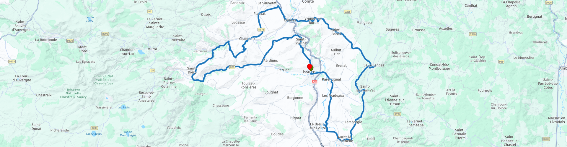
 The tour of over 100km through the Auvergne, starting and ending in Issoire, is an absolute must. Along the way you will get to know the hidden gems of the region, from medieval castles to charming villages that have defied time.
From the above follows a five star rating for this roundtrip; it actually shows all aspects that you can expect from this tour.
 Share this route


Animation

Verdict


Duration
5h 12m

Mode of travel
Car or motorcycle

Distance
107.48 km

Countries

 RouteXpert Review
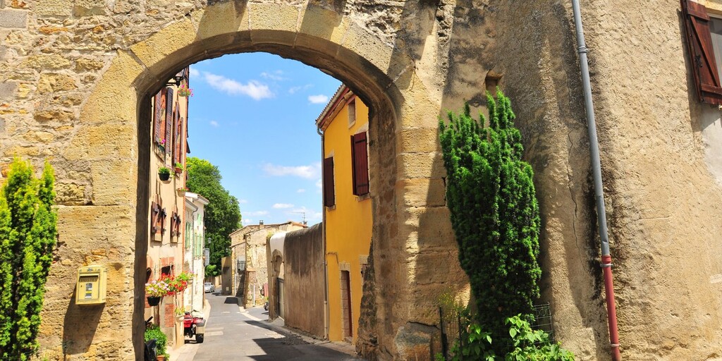
 You start the tour in Issoire, a charming town on the banks of the Allier. Visit the impressive Abbey Church of Saint-Austremoine, a masterpiece of Romanesque art with beautifully carved capitals and vibrant frescoes. Stroll through the historic centre and enjoy a cup of coffee on one of the pleasant squares before setting off.
A short distance away is Château de Parentignat, often called "the little Versailles of the Auvergne." This 17th-century castle houses one of the finest collections of French paintings outside the Louvre. The beautiful gardens and opulent interior provide a glimpse into the aristocratic lifestyle of yesteryear.
The first village you will visit is Nonette. The village is dominated to the south by a volcanic neck which rises to an altitude of 578 metres and dominates the Allier river at an altitude of 170 metres. It offers one of the most beautiful viewpoints in the region on the Mounts Dore, the Cézallier, the Cantal volcano, the Livradois, the Comté, the Puy-de-Dome... A path allows you to go around the hill and climb to the top. There are still some remains of the castle to be seen.
The half-Romanesque, half-Gothic church of St. Nicholas from the 14th and 15th centuries has preserved a beautiful carved Romanesque portal. The nave also preserves Romanesque sculptures on the figurative baskets, which complete the bestiary of the western portal. The "beautiful god" inside is a beautiful marble bust from the end of the 14th century.
Continue to Château Cocu, a picturesque ruin with a mysterious past. The ruin is set amidst rolling countryside and offers a perfect photo opportunity.
Usson is built on a volcanic peak that towers high above the Allier valley. The village has a beautiful ruin, a nice Romanesque church, a not so beautiful but large statue and a beautiful view over the Valley, the Monts Dore and the Puys. There is also an opportunity for a cup of coffee, which you will take advantage of... Above the village is a beautiful ruin of what must once have been a mighty castle. And it was, although it never really played a military role. Nevertheless, the castle of Usson appears twice in the history books. In the sixteenth century it was the prison of King Margot. Henry IV was fed up with the behavior of Margaret of Valois, as she was actually called, and sent her to Usson. Now those are measures to end a relationship! Although the ruin suggests that a fierce battle was fought here, that is not the case at all. The castle was demolished on the orders of Cardinal Richelieu because in his eyes it was too strong. It could easily become a hotbed of protest against the authorities in Paris.
Then you drive to Sauxillanges, where you can admire the remains of an old abbey. The abbey was once an important religious centre and the village still breathes a spiritual tranquility. In the 13th century, this monastery, which became a priory, reached its peak with the abbey church of Saint Pierre, the large cloister, the monastic buildings and the prior's chapel adjoining a second cloister. The Heritage House, located in the former prior's chapel, tells this beautiful story.
Montpeyroux is one of the “Plus Beaux Villages de France” and offers spectacular views over the region. Stroll through the cobbled streets and visit the old keep. It is situated on a hill around the ruins of an old castle and that is of course exactly what you would expect from an old French village. Of course, the view over the valley over the Allier is beautiful.
The houses in Montpeyroux are built with Arkose stone. This stone comes from the immediate area and has its own coppery colour. The castle's keep from the thirteenth century is still standing and can be visited.
Plauzat, an old fortified town, is the next stop. The lion fountain that adorns the church square is listed as a monument. The town hall is housed in the old castle from the 17th century, of which you can see part of the 14th century fortifications in the courtyard. Through the narrow streets you can recognize the old village fortress character.
The village of Champeix, built in a meander of the Couze Chambon, between hills planted with vineyards and terraced orchards, has a southern and wine-growing atmosphere. The houses of the winegrowers are brightly colored and the roofs are covered with red tiles with inconveniences. Climb the narrow streets of the Marchidial and admire the gardens and the panoramic view.
The village of Montaigut-leBlanc has a rich history that has clearly left its mark. Today, there are still around 600 inhabitants, but in the past it was a flourishing village that lived from wine growing. In the 12th and 13th centuries, the greatest period of prosperity for both the village and the castle took place. After that, the village deteriorated, mainly due to its accessibility. The 19th century brought about a change. Thanks to wine growing, the village was able to grow to around 1400 inhabitants and some inhabitants were rich enough to buy family windows in the church. At that time, the countless characteristic wine cellars in the village were also put into use. With a few major grape diseases and the outbreak of the First World War, this revival of the village came to an end.
Saurier, along the Couze Pavin, is a picturesque, former fortified village with a beautiful 15th century chicane bridge.
Saurier is distinguished by the presence of a medieval house whose function could be identified thanks to the louveterie (hunting) symbols engraved on the tympanum of the front door: wolf, hare, lily, horse. It was undoubtedly the home of a wolf lieutenant, charged by the king with controlling wild animals, organising wolf hunts and passing post on horseback.
The 15th century bridge is reminiscent of an old section of the road leading from the Allier valley to the mountain. Its three arches rest on as many beaked pillars, one of which carries a small protective oratory dedicated to the Virgin.
Saint-Floret is a beautiful example of a village in the Auvergne. The village is bisected by the fast-flowing river. The old bridge from the thirteenth century still ensures that the inhabitants can easily cross the water. Apparently they were very happy with that in the past because a small chapel, it is more like a cupboard, has been built in the middle of the bridge. That helps because there are not that many bridges from the Middle Ages anymore. With a view of the bridge you can have lunch here in the local inn.
At the top of the village is a Romanesque church where you can admire a painting and a statue of the Virgin Mary with her child from the fourteenth century. Behind the church is a cemetery. A poorly chosen location because burying the deceased villagers was difficult in the rocks. Eventually the graves were hewn from the stone and these sarcophagi are still there.
Without a castle you don't have a real French village and there is one in Saint-Floret. It is not exactly as it was delivered but we can appreciate a castle in a good state of decay, otherwise we go to the Elfteling, or Bruges.
Next to a tower there is another building and there is something special to see. On the walls are frescoes from the Middle Ages. Now they are special but usually they have a religious image, think of a local saint or a scene from the life of Jesus. Not here because these frescoes depict the story of Tristan and Isolde, the romantic story in the Middle Ages.
Even under a grey sky, Chadeleuf is a village full of warmth and colour; the ochres of the stones, the red of the roofs... An old wine-growing and fortified village, the village still has beautiful testimonies of its past.
The village was fortified around the 14th century to overcome the chronic insecurity after the Hundred Years' War. Of these fortifications we now find the tower, the entrance portal to the heart of the fortress, the rampart of the old castle.
From its wine-growing past, the village still has deep cellars, accessible via narrow alleys, covered passages and sloping staircases.
Before returning to Issoire, you will reach Sauvagnat, an old fortified town surrounded by hills and basalt plateaus. Here, colour sets the tone around the use of pink sandstone extracted from the subsoil. Discover the fortified door in the small streets of narrow houses. Some have benefited from a careful construction and present doors with a lintel sculpted with a bracket and windows with transoms dating from the 15th - 16th century. Elsewhere in the village, sumptuous houses with neat facades bear witness to the wine-growing success of the 19th century.
It is now on to Issoire. After parking, stroll through the historic centre and enjoy a coffee on one of the pleasant squares before ending your tour with a delicious dinner in one of the local restaurants.

 Links
Links  Usage
Usage Want to download this route?
You can download the route for free without MyRoute-app account. To do so, open the route and click 'save as'. Want to edit this route?
No problem, start by opening the route. Follow the tutorial and create your personal MyRoute-app account. After registration, your trial starts automatically.  Disclaimer
Use of this GPS route is at your own expense and risk. The route has been carefully composed and checked by a MyRoute-app accredited RouteXpert for use on TomTom, Garmin and MyRoute-app Navigation.
Changes may nevertheless have occurred due to changed circumstances, road diversions or seasonal closures. We therefore recommend checking each route before use.
Preferably use the route track in your navigation system. More information about the use of MyRoute-app can be found on the website under 'Community' or 'Academy'.

Auvergne Rhone Alpes
About this region
Auvergne-Rhône-Alpes (ARA; French: [ovɛʁɲ ʁon‿alp] (listen); Arpitan: Ôvèrgne-Rôno-Ârpes; Occitan: Auvèrnhe Ròse Aups; Italian: Alvernia-Rodano-Alpi) is a region in southeast-central France created by the 2014 territorial reform of French regions; it resulted from the merger of Auvergne and Rhône-Alpes. The new region came into effect on 1 January 2016, after the regional elections in December 2015.The region covers an area of 69,711 km2 (26,916 sq mi), making it the third largest in metropolitan France; it had a population of 7,948,287 in 2017, second to Île-de-France. It consists of twelve departments and one territorial collectivity (Lyon Metropolis) with Lyon as the prefecture.
This new region combines diverse geographical, sociological, economic and cultural regions, which was already true of Rhône-Alpes, as well as Auvergne, to a lesser extent. While the old Rhône-Alpes and Auvergne regions each enjoyed a unity defined by axes of communication and the pull of their respective metropoles, the new combination is heterogeneous; it sustained lively opposition from some local officials after its creation.
Read more on Wikipedia
This new region combines diverse geographical, sociological, economic and cultural regions, which was already true of Rhône-Alpes, as well as Auvergne, to a lesser extent. While the old Rhône-Alpes and Auvergne regions each enjoyed a unity defined by axes of communication and the pull of their respective metropoles, the new combination is heterogeneous; it sustained lively opposition from some local officials after its creation.
View region
 Statistics
  129
129Amount of RX reviews (Auvergne Rhone Alpes)
 57034
57034Amount of visitors (Auvergne Rhone Alpes)
 7117
7117Amount of downloads (Auvergne Rhone Alpes)
 Route Collections in this region
 The 24 Most Beautiful Alpine Routes
The Alps, The Alps are a mountain range in Europe, stretching from the French Mediterranean coast in the southwest to the Pannonian Plain in the east. The area of the mountain range is more than 200,000 km².
In other words Passes and Mountain Roads!
Driving through the mountains is great! Especially over the mountain passes with hairpin bends and narrow winding roads. Every bend a different view where you can enjoy. There are many beautiful mountain passes in the Alps.
A selection that has also been incorporated into these routes:
The Stlevio Pass:
The Stelvio Pass, also known as Passo dello Stelvio, is mainly known for the stage in the Giro d'Italia. Due to the length and the difference in height, this pass is seen as one of the toughest tests in cycling. The Stelvio Pass reaches a maximum height of 2758 meters and is therefore one of the highest in the Alps. The pass connects the towns of Bormio and Prato Allo Stelvio. In winter the pass is closed due to heavy snowfall.
The Reschenpass:
The Reschenpass, also known as Passo di Resia, connects the Austrian state of Tyrol with the Italian province of South Tyrol. The pass reaches a maximum height of 1,504 meters and has been one of the most important north-south connections in the Alps in recent centuries. The pass was used long before Roman times. Along the way you will pass several highlights and historical relics. One of the highlights is the Reschensee. This lake was created after the construction of the dam and has completely submerged the village of Graun. The only thing that reminds of that is the clock tower in the middle of the lake.
Col du Galibier:
The French mountain pass Col du Galibier connects the towns of Saint-Michel-de-Maurienne and Briançon via the Col du Lautaret in the south and the Col du Télégraphe in the north. The mountain pass is part of the Tour de France and very much feared, due to the fact that it can only be reached via the other two mountain passes. The pass reaches a maximum height of 2646 meters. From there you can take a walk to the viewpoint at 2704 meters. You can admire the peaks of the Grand Galibier, Mont Blanc and La Meije here.
The Grossglockner High Alpine Road:
With a height of 3798 meters the Grossglockner is the highest mountain in Austria. To fully enjoy this impressive mountain, you can drive over the Grossglockner High Alpine Road and the accompanying pass. The route starts from Bruck am Grossglockner and ends in Heiligenblut. Of course you can drive in two directions. The pass reaches a maximum height of 2504 meters and is closed in winter due to heavy snowfall. Along the way you pass several stops with fun activities, information points, mountain huts and viewpoints. A visit to the Kaiser-Franz-Josefs-Höhe and Pasterzen Glacier is highly recommended.
The Col d'Izoard:
Just like the Col du Galibier, the Col d'Izoard is also part of a stage of the Tour de France. The mountain pass connects Briançon with the valley of the river Guil. The pass is partly located in the Regional Natural Park du Queyras and reaches a maximum height of 2360 meters. What is special about the Col d'Izoard is the barren and rocky landscape. Sometimes it feels like driving a car over the moon! Along the way you can stop at several points to enjoy the beautiful view.
The Bernina Pass:
The Bernina Express is one of the most famous rail trains in Switzerland and the Alps. The route is beautiful and partly included on the UNESCO World Heritage List. Parallel to the railway lies the Bernina pass, which connects the Veltlin valley with the Egandin valley. This beautiful Alpine road has a total length of 56 kilometers and reaches a maximum height of 2328 meters. Along the way you can enjoy views of the Morteratsch Glacier.
The Sella Pass:
The Sella Pass, also known as Passo di Sella, takes you over one of the most impressive mountain ranges in the Dolomites: the Sella massif. The pass connects Valle di Fassa with Val Gardena and reaches a maximum height of 2236 meters. At this height is also the border of the Italian provinces of Trentino and Bolzano. Along the way you can enjoy the view of this spectacular mountain world. Admire, for example, the three peaks of the Sasso Lungo massif, the Sella massif or the peaks of the Marmolada. You can also drive the Sella pass in combination with the Gardena pass, Pordoi pass and Campolongo pass.
The Grimsel Pass:
The Grimsel Pass connects Goms in Wallis with the Halis Valley in the Bernese Oberland. The pass reaches a maximum elevation of 2165 meters and is closed in winter due to snowfall. Over the centuries, the mountain pass has played an important role in trade between Switzerland and Italy. Now it is mainly the reservoirs that have an important function. These are used to generate electricity. The landscape you drive through is rugged, rocky and impressive. On top of the pass is a hotel and a restaurant with a special marmot park. The Dodensee (Totensee) is also located here. This lake owes its name to the many soldiers who died in the time of Napoleon.
The Gotthard Pass:
The Gotthard Pass, also known as Passo del San Gottardo and Saint Gotthard, connects the Swiss towns of Airolo and Andermatt. The mountain pass and associated tunnel are especially known among holidaymakers driving from Switzerland to Italy. But where the majority opt for the tunnel, it is precisely the pass that really completes the holiday. The Gotthard Pass has a length of about 26 kilometers and reaches a maximum height of 2106 meters. The route is beautiful and takes you along old villages and beautiful views.
The Silvretta High Alpine Road and Silvretta Pass:
The Paznaun Valley in Tyrol and the Montafon in Vorarlberg are connected by the Silvretta High Alpine Road. The route has a length of 22.3 kilometers and leads from Galtür to Partenen in 34 hairpin bends, via the 2032 meter high Bielerhöhe. The Silvrettasee is also located at this point, where you can enjoy a lovely walk. The pass is closed in winter due to snowfall.
The Simplon Pass:
Just like the Gotthard Pass, many holidaymakers also travel over the Simplon Pass every year. This mountain pass connects the Rhone Valley in the canton of Valais with the Valle d'Ossola in Piemonte. The pass is open all year round and reaches a maximum height of 2005 meters. Along the way you pass a number of buildings, including the well-known Simplon Hospiz from 1825. The hospiz is managed by the monks of St. Bernard. From the highest point on the pass, all kinds of hiking routes are possible and you will also come across a hotel where you can spend the night.
The Gerlos Pass:
The Gerlos Pass connects the Salzach Valley in the Salzburgerland with the Zillertal Valley in Tyrol. The pass is part of the Gerlos Alpenstraße and runs right through the Hohe Tauern National Park. Along the way you can enjoy beautiful views of the surroundings. The pass has a length of 12 kilometers and reaches a maximum height of 1531 meters. A ride over the Gerlos Pass can be ideally combined with a visit to the Krimmler Wasserfälle.
The Great St. Bernard Pass:
The Great St. Bernard Pass, better known as Col du Grand Saint Bernard, connects the Italian province of Valle d'Aosta with the Swiss canton of Valais. The pass is one of the highest in Switzerland and reaches a maximum height of 2469 meters. Like a number of other mountain passes in this list, the Great St. Bernard Pass has also been used as a connecting road for centuries. The pass is named after the St. Bernard dogs that used to help stranded travelers along with the monks. The pass is closed in winter.
The Timmelsjoch High Alpine Road:
The Timmelsjoch High Alpine Road connects the towns of Sölden in the Ötztal and Meran in South Tyrol. Tolls must be paid on the Hochgurgl - Moos route. Via a mountain road with about 60 hairpin bends you drive through a beautiful mountain world. With the Timmelsjoch Experience you can learn more about the history, the road and the environment via various stations. You can also visit the Top Mountain Crosspoint museum.
Col de l'Iseran:
With a maximum pass height of 2770 meters, the Col l'Iséran is one of the highest mountain passes in the Alps. The pass connects Bourg-Saint-Maurice with Bonneval-sur-Arc. Via a road full of hairpin bends you pass, among other things, Val-d'Isère and a side valley of the Maurienne that lies entirely in the National Park de la Vanoise. You can spot animals such as marmots and chamois and there is also a restaurant with a chapel on top of the pass.
The Gavia Pass:
The Gavia Pass (Italian Passo di Gavia) is a mountain pass in the Italian Alps, in the Lombardy region.
It is one of the highest pass roads in Europe. The road leads through the unspoilt Stelvio National Park. The road was built in the First World War to supply Italian soldiers who fought in the Italian-Austrian border area. The pass height is one of the most beautiful in the Alps. Here is the large Lago Bianco with, to the north, the mountain San Matteo (3684 meters). Lago Nero is slightly lower on the south side of the pass. Here the mountain group of the Adamello determines the view. There are many well-marked walks in the area. During the winter the pass is closed due to the heavy snowfall. The pass is often closed until May and June due to the large amount of snow.
Promoter has made a selection of the 24 Most Beautiful Alpine routes that they have set out in recent years.
The routes go through:
France
Austria
Switzerland
Italy
The most beautiful roads, the most beautiful views, the most beautiful viewpoints. The highest mountains, the fastest descents, hairpin bend after hairpin bend, you name it you can't get enough of it.
If you go on holiday in this region, take advantage of it, ALL routes in this collection have been checked and made equal for TomTom, Garmin and MyRoute-app Navigation by a MyRoute-app RouteXpert.
Have fun with this collection and while driving one of these routes. Enjoy all the beauty that the Alps and the Dolomites have to offer. Click on “View route” to read the review of the chosen route.
I would like to hear your findings about the route(s).
View Route Collection
25 Magnificent trails in France
This MRA route collection contains 25 beautiful motorcycle routes in different parts of France, such as the Ardennes, the Alsace, Vercors, the Drôme, the Ardèche, Cote d'Azure, Gorges du Verdon, the Ariège, the Dordogne and Brittany.
The routes have been carefully created by Bert Loorbach, who is an enthusiastic motorcyclist himself. He lived in France for a year and a half, during which time he devoted himself to mapping the unknown and beautiful back roads of France especially for motorcyclists.
The routes are bundled in the Motortourgids France part 1 of Kosmos publishing house and now also available in MyRouteApp.
I have taken over the routes in MRA and sometimes adjusted them slightly to make them even more interesting for the motorcyclist.
View Route Collection