Auvergne Roundtrip from Brioude

This route was brought to you by:
RouteXpert Jan Koelstra - Senior Rx
Last edit: 03-04-2025
 Route Summary
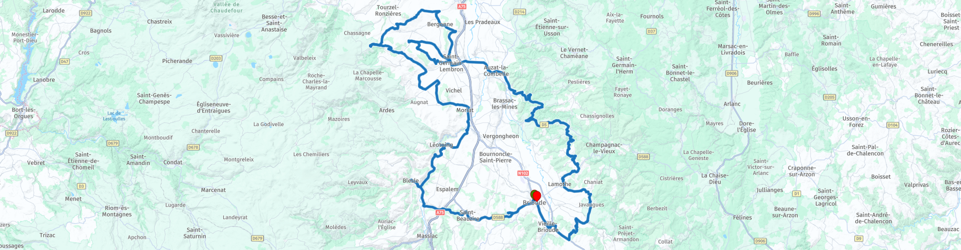
 The 150km round trip through the southern Auvergne, starting and ending in Brioude, is an absolute must. Along the way you will get to know the hidden gems of the region, from medieval castles to charming villages that have defied time.
From the above follows a five star rating for this roundtrip; it actually shows all aspects that you can expect from this tour.
 Share this route


Animation

Verdict


Duration
7h 29m

Mode of travel
Car or motorcycle

Distance
177.18 km

Countries

 RouteXpert Review
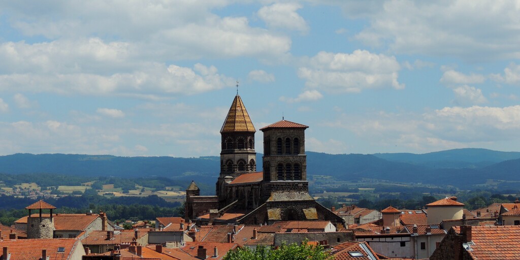
 You start this tour in Brioude. A small town in Haute-Loire; yes, small but nice. Brioude presents itself as a city of art and crafts. But the town is certainly worth a visit for many other reasons. For example, Brioude has a beautiful church, the Basilique Saint-Julien. This church is known as one of the most beautiful basilicas in the South of France. The history of this basilica begins in the year 304, when a Roman hero who had converted to Christianity fled to Brioude and was killed here. The place where the Roman was buried quickly became a place of pilgrimage. Because of its location on one of the pilgrimage routes to Santiago de Compostela, it was decided to build a basilica here in the 12th century. Today you can walk into this beautiful church and its frescoes. It is also wonderful to stroll through the old center of Brioude. Here you will find old shops and boutiques. Just outside the centre you will find Maison du Saumon et de la Rivière. In this educational museum you can admire more than 35 different species of fish. The Maison de Mandrin is also worth a visit. Here you will find a collection of different works of art.
Just outside Brioude you will soon come across a petrol station. The next village on your route is Saint-Laurent-Chabreuges. If you are lucky to drive past on a good day, you can visit the Voltige brewery. In this village, without a church or cemetery, there is the beautiful castle of Chabreuges. In the next village Saint-Beauzire there is another nice church, no castle in the village but at least three spread out in the surrounding landscape.
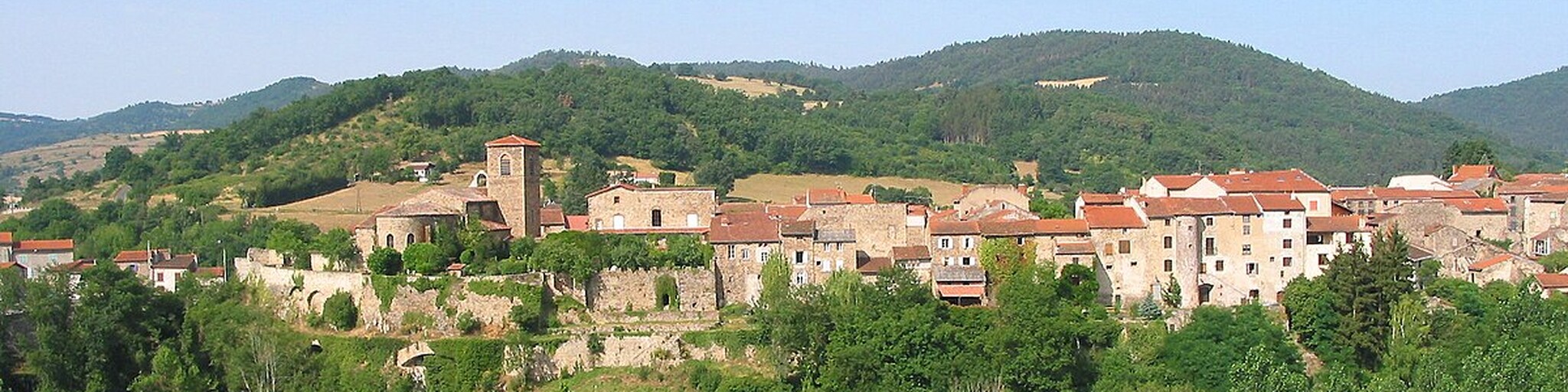
Blesle has been recognised as one of the most beautiful villages in France by the organisation Les Plus Beaux Villages de France. And that means of course: drinking coffee. The donjon des Mercoeur is the only remnant of a medieval castle. A women's abbey was founded there in the 9th century under papal protection. The absolute highlight of Blesle is the Romanesque abbey church Saint-Pierre; a church with interesting stone ornaments and brightly coloured walls on the inside. The frescoes date from the 19th century and attempt to imitate a painted Romanesque choir. But the fourteenth-century bell tower of the Saint-Martin church is also worth a visit. It is the only thing left of the original church. And what about the Massadou watchtower? It dates from the thirteenth century and is located halfway up the hill. It also gives you a beautiful view of the former city walls and the old half-timbered houses. Of course, Blesle also has a few restaurants and bistros where you can enjoy typical French dishes made from fresh local produce. So maybe a pastry with your coffee?
After coffee you drive along the river to the next village Léotoing. On the way across the water you can see the mighty castle of Torsiac.
Léotoing is a charming little medieval village in the Haute-Loire where it is good to stroll through the narrow streets to discover a very rich heritage... It is also the starting point for beautiful walks with breathtaking views. The first stop of your visit, when you enter the village, is the Leper Chapel. Inside, you can discover a beautiful model of the village and documentary panels, while outside you can admire the breathtaking view of the Allagnon gorges and the Cézallier mountains. There is also an orientation table. In the village, you will discover the old school, the communal oven, the ramparts, the fortified gate, the Romanesque St. Vincent church and the castle.
All that remains of this private castle today are the ruins. But with a free application on tablets and smartphones that can be downloaded in front of the town hall, you can experience the visit as it was in the Middle Ages.
The village of Boudes was once a fortified town. Admire the old houses with their Genoese-style roofs that are not seen anywhere else. The village also preserves the remains of an old polygonal fortress and the ruins of a keep.
If you are in Boudes, you must visit the Vallée des Saints with its figures carved in ochre clay. The many wineries of Boudes bear witness to the wine-growing tradition of this village. Today, the cellars of the Boudes winegrowers show that this tradition is still relevant.
The village of Le Broc, built at the end of a basalt stream, is worth a visit. On the edge of the plateau, high above the motorway, the panorama is magnificent. The fortified village, expertly restored, is part of the relief.
Somewhere between the 11th and 13th century, the Broc castle and its village were built. Go into the village to visit the fortified area and the ruins of the castle. At the limestone chapel, you can see the high square keep that was built around the 13th century and is provided with a rampart.
The name Villeneuve shows that the village was founded late. It was built from the 12th century around the grand Hôtel Aureille. You can see the square tower there which, with its 20 m height, offers an exceptional view. This tower is probably one of the last of its kind still standing in France. The castle of Rigaud d'Aureille has beautiful murals; some of them are depicted as morals. The castle can be visited all year round. The wash house of La Mouleyre is also a place to see.
From the river at the bottom of the village, Auzon climbs 50 metres to the magnificent 12th century church at the top. Around the church is a cluster of stone houses, often three stories high.
You can park in the car park at the bottom of the village and take one of the paved paths up, passing through the fortified stone gateway on the way. Some of the original protective walls that defended the village in the Middle Ages still remain, as do parts of the old castle. While you’re there, consider where to stop for lunch in the village. Sadly, there are few remains of the Chateau d’Auzon, which was largely destroyed in the 17th century and further damaged after the Revolution, but you can still see a tower and a series of arcaded windows.
The medieval centre of Auzon is very pretty, especially the church with its large arched entrance, which is mirrored by the stone arch leading to one of the houses behind it. The church of Saint Laurent was built in the 12th century and is a listed historical monument. It is a beautiful example of Romanesque architecture, with fine carved capitals and some excellent murals painted in the 14th and 16th centuries.
If the church of Auzon has inspired you to seek out other beautiful examples of Romanesque architecture, then the next place to visit is the Abbey of Lavaudieu, the most beautiful Romanesque building in the Livradois-Forez area. But first, follow the magnificent route through the woods with its delightful winding and undulating curves.
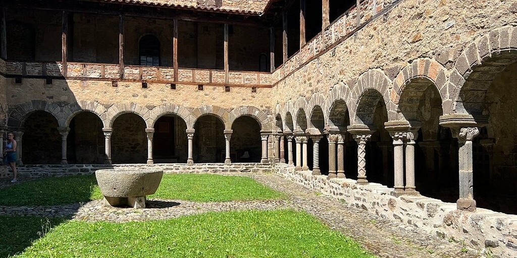
Lavaudieu is also part of the so-called “Les Plus Beaux Villages de France”. So with the same excuse as in Blesle: it is time for a drink again. The town is mainly known for its impressive abbey from the 11th century. The abbey has a beautiful cloister that is still in good condition. In addition, the abbey also has beautiful frescoes in the various dining rooms from the 12th century. Next to the abbey is the abbey church with an octagonal bell tower that you can also visit. The town has a mighty defensive wall and a historic center. From the old stone bridge you have a beautiful view of the town. Do you want to learn more about the history of the town? Then you can go to the Museum of Popular Arts and Traditions.
Then the ride heads back towards Brioude. First you will pass through Vieille-Brioude. Thanks to the sunny slopes, Vieille-Brioude has a flourishing wine industry. From the Middle Ages onwards, this place was the most important wine-growing centre of the Pays de Brioude. But the phylloxera, the mildew and the departure of many men from the front lines of the First World War got the upper hand. However, the hills still bear the traces of this culture: terraces, winegrowers' huts. After this, it is a short distance to Brioude, where you end your ride in a pleasant way.
 Links
Links  Usage
Usage Want to download this route?
You can download the route for free without MyRoute-app account. To do so, open the route and click 'save as'. Want to edit this route?
No problem, start by opening the route. Follow the tutorial and create your personal MyRoute-app account. After registration, your trial starts automatically.  Disclaimer
Use of this GPS route is at your own expense and risk. The route has been carefully composed and checked by a MyRoute-app accredited RouteXpert for use on TomTom, Garmin and MyRoute-app Navigation.
Changes may nevertheless have occurred due to changed circumstances, road diversions or seasonal closures. We therefore recommend checking each route before use.
Preferably use the route track in your navigation system. More information about the use of MyRoute-app can be found on the website under 'Community' or 'Academy'.

Auvergne Rhone Alpes
About this region
Auvergne-Rhône-Alpes (ARA; French: [ovɛʁɲ ʁon‿alp] (listen); Arpitan: Ôvèrgne-Rôno-Ârpes; Occitan: Auvèrnhe Ròse Aups; Italian: Alvernia-Rodano-Alpi) is a region in southeast-central France created by the 2014 territorial reform of French regions; it resulted from the merger of Auvergne and Rhône-Alpes. The new region came into effect on 1 January 2016, after the regional elections in December 2015.The region covers an area of 69,711 km2 (26,916 sq mi), making it the third largest in metropolitan France; it had a population of 7,948,287 in 2017, second to Île-de-France. It consists of twelve departments and one territorial collectivity (Lyon Metropolis) with Lyon as the prefecture.
This new region combines diverse geographical, sociological, economic and cultural regions, which was already true of Rhône-Alpes, as well as Auvergne, to a lesser extent. While the old Rhône-Alpes and Auvergne regions each enjoyed a unity defined by axes of communication and the pull of their respective metropoles, the new combination is heterogeneous; it sustained lively opposition from some local officials after its creation.
Read more on Wikipedia
This new region combines diverse geographical, sociological, economic and cultural regions, which was already true of Rhône-Alpes, as well as Auvergne, to a lesser extent. While the old Rhône-Alpes and Auvergne regions each enjoyed a unity defined by axes of communication and the pull of their respective metropoles, the new combination is heterogeneous; it sustained lively opposition from some local officials after its creation.
View region
 Statistics
  129
129Amount of RX reviews (Auvergne Rhone Alpes)
 57078
57078Amount of visitors (Auvergne Rhone Alpes)
 7123
7123Amount of downloads (Auvergne Rhone Alpes)
 Route Collections in this region
 The 24 Most Beautiful Alpine Routes
The Alps, The Alps are a mountain range in Europe, stretching from the French Mediterranean coast in the southwest to the Pannonian Plain in the east. The area of the mountain range is more than 200,000 km².
In other words Passes and Mountain Roads!
Driving through the mountains is great! Especially over the mountain passes with hairpin bends and narrow winding roads. Every bend a different view where you can enjoy. There are many beautiful mountain passes in the Alps.
A selection that has also been incorporated into these routes:
The Stlevio Pass:
The Stelvio Pass, also known as Passo dello Stelvio, is mainly known for the stage in the Giro d'Italia. Due to the length and the difference in height, this pass is seen as one of the toughest tests in cycling. The Stelvio Pass reaches a maximum height of 2758 meters and is therefore one of the highest in the Alps. The pass connects the towns of Bormio and Prato Allo Stelvio. In winter the pass is closed due to heavy snowfall.
The Reschenpass:
The Reschenpass, also known as Passo di Resia, connects the Austrian state of Tyrol with the Italian province of South Tyrol. The pass reaches a maximum height of 1,504 meters and has been one of the most important north-south connections in the Alps in recent centuries. The pass was used long before Roman times. Along the way you will pass several highlights and historical relics. One of the highlights is the Reschensee. This lake was created after the construction of the dam and has completely submerged the village of Graun. The only thing that reminds of that is the clock tower in the middle of the lake.
Col du Galibier:
The French mountain pass Col du Galibier connects the towns of Saint-Michel-de-Maurienne and Briançon via the Col du Lautaret in the south and the Col du Télégraphe in the north. The mountain pass is part of the Tour de France and very much feared, due to the fact that it can only be reached via the other two mountain passes. The pass reaches a maximum height of 2646 meters. From there you can take a walk to the viewpoint at 2704 meters. You can admire the peaks of the Grand Galibier, Mont Blanc and La Meije here.
The Grossglockner High Alpine Road:
With a height of 3798 meters the Grossglockner is the highest mountain in Austria. To fully enjoy this impressive mountain, you can drive over the Grossglockner High Alpine Road and the accompanying pass. The route starts from Bruck am Grossglockner and ends in Heiligenblut. Of course you can drive in two directions. The pass reaches a maximum height of 2504 meters and is closed in winter due to heavy snowfall. Along the way you pass several stops with fun activities, information points, mountain huts and viewpoints. A visit to the Kaiser-Franz-Josefs-Höhe and Pasterzen Glacier is highly recommended.
The Col d'Izoard:
Just like the Col du Galibier, the Col d'Izoard is also part of a stage of the Tour de France. The mountain pass connects Briançon with the valley of the river Guil. The pass is partly located in the Regional Natural Park du Queyras and reaches a maximum height of 2360 meters. What is special about the Col d'Izoard is the barren and rocky landscape. Sometimes it feels like driving a car over the moon! Along the way you can stop at several points to enjoy the beautiful view.
The Bernina Pass:
The Bernina Express is one of the most famous rail trains in Switzerland and the Alps. The route is beautiful and partly included on the UNESCO World Heritage List. Parallel to the railway lies the Bernina pass, which connects the Veltlin valley with the Egandin valley. This beautiful Alpine road has a total length of 56 kilometers and reaches a maximum height of 2328 meters. Along the way you can enjoy views of the Morteratsch Glacier.
The Sella Pass:
The Sella Pass, also known as Passo di Sella, takes you over one of the most impressive mountain ranges in the Dolomites: the Sella massif. The pass connects Valle di Fassa with Val Gardena and reaches a maximum height of 2236 meters. At this height is also the border of the Italian provinces of Trentino and Bolzano. Along the way you can enjoy the view of this spectacular mountain world. Admire, for example, the three peaks of the Sasso Lungo massif, the Sella massif or the peaks of the Marmolada. You can also drive the Sella pass in combination with the Gardena pass, Pordoi pass and Campolongo pass.
The Grimsel Pass:
The Grimsel Pass connects Goms in Wallis with the Halis Valley in the Bernese Oberland. The pass reaches a maximum elevation of 2165 meters and is closed in winter due to snowfall. Over the centuries, the mountain pass has played an important role in trade between Switzerland and Italy. Now it is mainly the reservoirs that have an important function. These are used to generate electricity. The landscape you drive through is rugged, rocky and impressive. On top of the pass is a hotel and a restaurant with a special marmot park. The Dodensee (Totensee) is also located here. This lake owes its name to the many soldiers who died in the time of Napoleon.
The Gotthard Pass:
The Gotthard Pass, also known as Passo del San Gottardo and Saint Gotthard, connects the Swiss towns of Airolo and Andermatt. The mountain pass and associated tunnel are especially known among holidaymakers driving from Switzerland to Italy. But where the majority opt for the tunnel, it is precisely the pass that really completes the holiday. The Gotthard Pass has a length of about 26 kilometers and reaches a maximum height of 2106 meters. The route is beautiful and takes you along old villages and beautiful views.
The Silvretta High Alpine Road and Silvretta Pass:
The Paznaun Valley in Tyrol and the Montafon in Vorarlberg are connected by the Silvretta High Alpine Road. The route has a length of 22.3 kilometers and leads from Galtür to Partenen in 34 hairpin bends, via the 2032 meter high Bielerhöhe. The Silvrettasee is also located at this point, where you can enjoy a lovely walk. The pass is closed in winter due to snowfall.
The Simplon Pass:
Just like the Gotthard Pass, many holidaymakers also travel over the Simplon Pass every year. This mountain pass connects the Rhone Valley in the canton of Valais with the Valle d'Ossola in Piemonte. The pass is open all year round and reaches a maximum height of 2005 meters. Along the way you pass a number of buildings, including the well-known Simplon Hospiz from 1825. The hospiz is managed by the monks of St. Bernard. From the highest point on the pass, all kinds of hiking routes are possible and you will also come across a hotel where you can spend the night.
The Gerlos Pass:
The Gerlos Pass connects the Salzach Valley in the Salzburgerland with the Zillertal Valley in Tyrol. The pass is part of the Gerlos Alpenstraße and runs right through the Hohe Tauern National Park. Along the way you can enjoy beautiful views of the surroundings. The pass has a length of 12 kilometers and reaches a maximum height of 1531 meters. A ride over the Gerlos Pass can be ideally combined with a visit to the Krimmler Wasserfälle.
The Great St. Bernard Pass:
The Great St. Bernard Pass, better known as Col du Grand Saint Bernard, connects the Italian province of Valle d'Aosta with the Swiss canton of Valais. The pass is one of the highest in Switzerland and reaches a maximum height of 2469 meters. Like a number of other mountain passes in this list, the Great St. Bernard Pass has also been used as a connecting road for centuries. The pass is named after the St. Bernard dogs that used to help stranded travelers along with the monks. The pass is closed in winter.
The Timmelsjoch High Alpine Road:
The Timmelsjoch High Alpine Road connects the towns of Sölden in the Ötztal and Meran in South Tyrol. Tolls must be paid on the Hochgurgl - Moos route. Via a mountain road with about 60 hairpin bends you drive through a beautiful mountain world. With the Timmelsjoch Experience you can learn more about the history, the road and the environment via various stations. You can also visit the Top Mountain Crosspoint museum.
Col de l'Iseran:
With a maximum pass height of 2770 meters, the Col l'Iséran is one of the highest mountain passes in the Alps. The pass connects Bourg-Saint-Maurice with Bonneval-sur-Arc. Via a road full of hairpin bends you pass, among other things, Val-d'Isère and a side valley of the Maurienne that lies entirely in the National Park de la Vanoise. You can spot animals such as marmots and chamois and there is also a restaurant with a chapel on top of the pass.
The Gavia Pass:
The Gavia Pass (Italian Passo di Gavia) is a mountain pass in the Italian Alps, in the Lombardy region.
It is one of the highest pass roads in Europe. The road leads through the unspoilt Stelvio National Park. The road was built in the First World War to supply Italian soldiers who fought in the Italian-Austrian border area. The pass height is one of the most beautiful in the Alps. Here is the large Lago Bianco with, to the north, the mountain San Matteo (3684 meters). Lago Nero is slightly lower on the south side of the pass. Here the mountain group of the Adamello determines the view. There are many well-marked walks in the area. During the winter the pass is closed due to the heavy snowfall. The pass is often closed until May and June due to the large amount of snow.
Promoter has made a selection of the 24 Most Beautiful Alpine routes that they have set out in recent years.
The routes go through:
France
Austria
Switzerland
Italy
The most beautiful roads, the most beautiful views, the most beautiful viewpoints. The highest mountains, the fastest descents, hairpin bend after hairpin bend, you name it you can't get enough of it.
If you go on holiday in this region, take advantage of it, ALL routes in this collection have been checked and made equal for TomTom, Garmin and MyRoute-app Navigation by a MyRoute-app RouteXpert.
Have fun with this collection and while driving one of these routes. Enjoy all the beauty that the Alps and the Dolomites have to offer. Click on “View route” to read the review of the chosen route.
I would like to hear your findings about the route(s).
View Route Collection
25 Magnificent trails in France
This MRA route collection contains 25 beautiful motorcycle routes in different parts of France, such as the Ardennes, the Alsace, Vercors, the Drôme, the Ardèche, Cote d'Azure, Gorges du Verdon, the Ariège, the Dordogne and Brittany.
The routes have been carefully created by Bert Loorbach, who is an enthusiastic motorcyclist himself. He lived in France for a year and a half, during which time he devoted himself to mapping the unknown and beautiful back roads of France especially for motorcyclists.
The routes are bundled in the Motortourgids France part 1 of Kosmos publishing house and now also available in MyRouteApp.
I have taken over the routes in MRA and sometimes adjusted them slightly to make them even more interesting for the motorcyclist.
View Route Collection