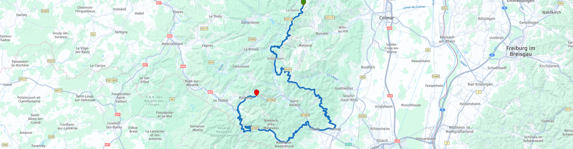
Rondrit in de Vogezen vanuit Bussang gebaseerd op de Route des Cretes deel 2

This route was brought to you by:
RouteXpert Patrick Lemaire - RouteXpert
Last edit: 07-06-2025
 Route Summary
 This is the second part of this loop - from the lunch spot in Gazon du Faing back to the Col de Bussang motohotel in the commune of Bussang.
This route therefore receives a rating of 4 stars.
 Share this route


Animation

Verdict


Duration
6h 1m

Mode of travel
Car or motorcycle

Distance
144.05 km

Countries

 RouteXpert Review
 A few kilometres after the start, the Col de la Schlucht is already up. Incidentally, this is the highest mountain pass in the Vosges with an altitude of 1139 m. This pass connects the Vosges with Alsace. In winter, it is an important ski area and in summer the starting point of many hiking trails.
Past the summit, take the left turn to stop a little further on at the Jardin botanique du Haut-Chitelet. The Haut Chitelet high-altitude garden offers its visitors the chance to discover 2,500 species of alpine plants from various mountain regions around the world. A stone's throw from Hohneck, primroses, gentians, blue poppies, edelweiss and many more flowers bloom in landscaped rockeries.
A peat bog and a high-altitude beech forest, two characteristic natural areas of the Hautes-Vosges, complete this botanical world trip. Definitely recommended for plant lovers. (see link 2)
After a walk in the alpine garden, you continue to the turnoff to the Hohneck. The summit "Le Hohneck", with 1363m the third highest of the Vosges, is located in La Bresse. From there you can see Alsace, and with clear weather the Black Forest and even the Alps. On the mountain there is a mountain hut with restaurant and a shop. One of the better viewpoints in the Vosges.
After the short stop, it goes back down to continue the planned route. Be careful at route point 5, there is a very sharp turn to the right towards Col du Bramont.
Once you have passed this peak, a beautiful series of 14 hairpin bends awaits you. Here, the edges of your tires will disappear without any problem, before you reach the Lac de Kruth-Wildenstein. Do pay attention to route point 8, because you leave the D13B to the left towards Le Markstein.
Another resounding name in this area, especially since several roads meet at this summit. In winter it is a ski area with blue and green slopes, suitable for beginners.
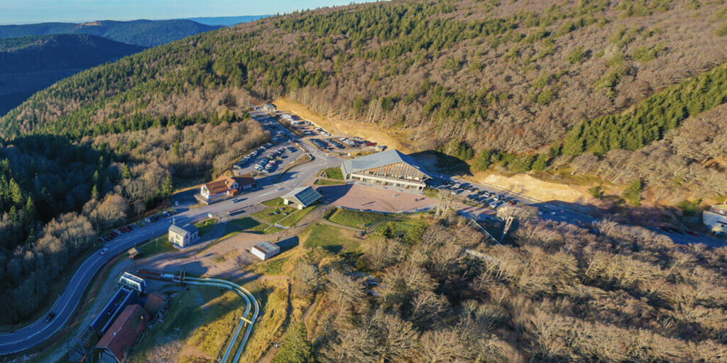
The next peak after Le Markstein is perhaps the most famous - namely Le Grand Ballon. Due to the semi-circular shape, some mountain peaks here are given the name Ballon. And this is the highest... There are a few bar-restaurants, a large parking lot and the view is spectacular in clear weather. That is also the reason why most passers-by stop here for a while. If you prefer it a bit quieter, there are other possibilities to eat something.
Then there is the Hartsmannswillerskofp. Not only a mountain top, but also a memorial site. During the First World War, fierce battles took place here between the French and the Germans. You will find a military cemetery with a chapel, but also some trenches and bunkers. For those interested in this war and history in general, a very interesting place to visit. (see link 3)
A little further on you can leave the Route des Crêtes for a drink break on the Molkenrain. To do this, take the dead-end road to the right until the end. The Auberge du Molkenrain has a terrace with a beautiful view of the lower terrain. For enthusiasts, it is also the perfect place to let the drone out for a while. It is less crowded than at many other highlights. (see link 4)
Back down, you will stay on the Route des Crêtes for a while, but it ends just before Cernay. It will be a bit busier, but after a few kilometres, you will leave the D1066 again in Bitschwiller-les-Thann. Col du Hundsruck is next. This road was built in the First World War to better supply the French troops. That is one of the only positive consequences of this war, because it is quite a nice road.
A little further, at the beginning of the Col Ballon d'Alsace mountain pass, is the Lac d'Alfeld reservoir. The Germans dammed the river with a 30 m high dike to raise the water level of the lake. This happened between 1883 and 1888. At that time it was a real technical feat. A walk on the dike and you will certainly enjoy the surrounding nature and views.
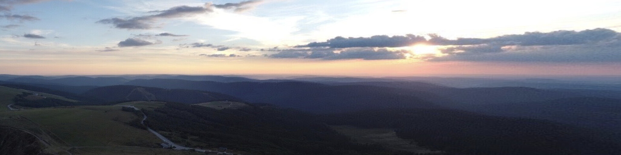
Finally, the last highlight of this ride - Col Ballon d'Alsace. Usually it is much less crowded there, especially in the late afternoon. With some luck, the lower sun spreads a warm, soft light over the landscape. Then it is really enjoyable.
On the way back to the hotel you can still fill up in Bussang. Note that this is a smaller petrol station, so not ideal for larger groups.
After this ride you can tick off most of the Cols in this beautiful region and, tired but satisfied, enjoy the local cuisine, accompanied by the necessary fluids in Motohotel Col de Bussang (see link 5)

 Links
Links  Usage
Usage Want to download this route?
You can download the route for free without MyRoute-app account. To do so, open the route and click 'save as'. Want to edit this route?
No problem, start by opening the route. Follow the tutorial and create your personal MyRoute-app account. After registration, your trial starts automatically.  Disclaimer
Use of this GPS route is at your own expense and risk. The route has been carefully composed and checked by a MyRoute-app accredited RouteXpert for use on TomTom, Garmin and MyRoute-app Navigation.
Changes may nevertheless have occurred due to changed circumstances, road diversions or seasonal closures. We therefore recommend checking each route before use.
Preferably use the route track in your navigation system. More information about the use of MyRoute-app can be found on the website under 'Community' or 'Academy'.

Grand Est
About this region
Grand Est (French: [ɡʁɑ̃t‿ɛst] (listen); Alsatian: Grossa Oschta; Moselle Franconian/Luxembourgish: Grouss Osten;
Rhine Franconian: Groß Oschte; German: Großer Osten [ˈɡʁoːsɐ ˈʔɔstn̩]; English: "Greater East") is an administrative region in Northeastern France. It superseded three former administrative regions, Alsace, Champagne-Ardenne and Lorraine, on 1 January 2016 under the provisional name of Alsace-Champagne-Ardenne-Lorraine (pronounced [alzas ʃɑ̃paɲ aʁdɛn lɔʁɛn]; ACAL or, less commonly, ALCA), as a result of territorial reform which had been passed by the French Parliament in 2014.The region sits astride three water basins (Seine, Meuse and Rhine), spanning an area of 57,433 km2 (22,175 sq mi), the fifth largest in France; it includes two mountain ranges (Vosges and Ardennes). It shares borders with Belgium, Luxembourg, Germany and Switzerland. As of 2017, it had a population of 5,549,586 inhabitants. The prefecture and largest city, by far, is Strasbourg.
The East of France has a rich and diverse culture, being situated at a crossroads between the Latin and Germanic worlds. This history is reflected in the variety of languages spoken there (Alsatian, Champenois, and Lorraine Franconian). Most of today's Grand Est region was considered "Eastern" as early as the 8th century, when it constituted the southern part of the Francian territory of Austrasia. The city of Reims (in Champagne), where Frankish king Clovis I had been baptized in 496 AD, would later play a prominent ceremonial role in French monarchical history as the traditional site of the coronation of the kings of France. The Champagne fairs played a significant role in the economy of medieval Europe as well. Alsace and Lorraine thrived in the sphere of influence of the Holy Roman Empire for most of the Middle Ages and Renaissance, and subject to competing claims by France and German over the centuries.
The region has distinctive traditions such as the celebration of Saint Nicholas Day, Christmas markets, or traditions involving the Easter hare in Alsace and Lorraine. Alsace-Moselle are furthermore subject to local law for historical reasons. With a long industrial history and strong agriculture and tourism (arts, gastronomy, sightseeing), the East of France is one of the top economic producing regions in the country.
Read more on Wikipedia
Rhine Franconian: Groß Oschte; German: Großer Osten [ˈɡʁoːsɐ ˈʔɔstn̩]; English: "Greater East") is an administrative region in Northeastern France. It superseded three former administrative regions, Alsace, Champagne-Ardenne and Lorraine, on 1 January 2016 under the provisional name of Alsace-Champagne-Ardenne-Lorraine (pronounced [alzas ʃɑ̃paɲ aʁdɛn lɔʁɛn]; ACAL or, less commonly, ALCA), as a result of territorial reform which had been passed by the French Parliament in 2014.The region sits astride three water basins (Seine, Meuse and Rhine), spanning an area of 57,433 km2 (22,175 sq mi), the fifth largest in France; it includes two mountain ranges (Vosges and Ardennes). It shares borders with Belgium, Luxembourg, Germany and Switzerland. As of 2017, it had a population of 5,549,586 inhabitants. The prefecture and largest city, by far, is Strasbourg.
The East of France has a rich and diverse culture, being situated at a crossroads between the Latin and Germanic worlds. This history is reflected in the variety of languages spoken there (Alsatian, Champenois, and Lorraine Franconian). Most of today's Grand Est region was considered "Eastern" as early as the 8th century, when it constituted the southern part of the Francian territory of Austrasia. The city of Reims (in Champagne), where Frankish king Clovis I had been baptized in 496 AD, would later play a prominent ceremonial role in French monarchical history as the traditional site of the coronation of the kings of France. The Champagne fairs played a significant role in the economy of medieval Europe as well. Alsace and Lorraine thrived in the sphere of influence of the Holy Roman Empire for most of the Middle Ages and Renaissance, and subject to competing claims by France and German over the centuries.
The region has distinctive traditions such as the celebration of Saint Nicholas Day, Christmas markets, or traditions involving the Easter hare in Alsace and Lorraine. Alsace-Moselle are furthermore subject to local law for historical reasons. With a long industrial history and strong agriculture and tourism (arts, gastronomy, sightseeing), the East of France is one of the top economic producing regions in the country.
View region
 Statistics
  84
84Amount of RX reviews (Grand Est)
 42696
42696Amount of visitors (Grand Est)
 14338
14338Amount of downloads (Grand Est)
 Route Collections in this region
 25 Magnificent trails in France
This MRA route collection contains 25 beautiful motorcycle routes in different parts of France, such as the Ardennes, the Alsace, Vercors, the Drôme, the Ardèche, Cote d'Azure, Gorges du Verdon, the Ariège, the Dordogne and Brittany.
The routes have been carefully created by Bert Loorbach, who is an enthusiastic motorcyclist himself. He lived in France for a year and a half, during which time he devoted himself to mapping the unknown and beautiful back roads of France especially for motorcyclists.
The routes are bundled in the Motortourgids France part 1 of Kosmos publishing house and now also available in MyRouteApp.
I have taken over the routes in MRA and sometimes adjusted them slightly to make them even more interesting for the motorcyclist.
View Route Collection
11 day trip from the Netherlands
8 countries in 11 days; The Netherlands, Germany, Austria, Italy, Switzerland, France, Luxembourg and Belgium. This route collections consists of 10 routes that I have driven with friends in the summer of 2019.
The start is in Geldermalsen Netherlands, the first 7 days you drive through the Netherlands, Germany, Austria, Italy, Switzerland, France and a piece of Luxembourg with overnight stays in hotels.
The last three days you stay in Barweiler (D) in the Eifel and you drive two beautiful tours through the Eifel, Luxembourg and parts of the Belgian Ardennes.
There is no highway in the routes, only beautiful provincial and country roads, many beautiful passes with beautiful panoramas.
Be sure to check whether the passes are open before you leave.
These are routes for experienced drivers.
View Route Collection