MTG1 03 Gerardmer Lac Blanc Le Hohneck Cernay

This route was brought to you by:
RouteXpert René Plücken (MRA Master)
Last edit: 20-08-2025
 Route Summary
 This route includes several beautiful cols, such as the Col de la Schlucht, Col du Calvaire, and Collet du Linge. You'll ride past mountain lakes with beautiful, clear water, through forests, over mountain ridges (crêtes), and through valleys with steep climbs and plenty of bends.
The ride takes you along beautiful, high-quality mountain roads with plenty of twists and turns. There's plenty to see along the way, and you can park at viewpoints. I rate this route 5 stars.
 Share this route


Animation

Verdict


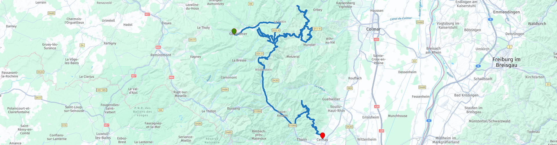
Duration
6h 2m

Mode of travel
Car or motorcycle

Distance
144.29 km

Countries

 RouteXpert Review
 Bert Loorbach, the author, is an avid motorcyclist himself and lived in France for a year and a half. During that time, he dedicated himself to mapping France's lesser-known and beautiful back roads specifically for motorcyclists.
This is the third route in the book. It starts in Gérardmer and ends in Chernay.
There are hotels and campsites in the vicinity, these are included as POIs.
This route includes several beautiful passes (cols) such as the Col de La Schlucht, Col du Calvaire and Collet du Linge.
The ride starts in Gérardmer, nestled among mountains covered in dense pine forests, on the largest lake in the Vosges Mountains: Lac de Gérardmer. It's a great base for several rides, and this is one of three routes that start here.
This route follows mountain ridges (crêtes) and is more than half forested. The first pass is the Col de la Schlucht, an east-west oriented mountain pass located on the border of the Vosges and Haut-Rhin departments. The pass route begins in the west from Gérardmer at 660 meters above sea level and begins to climb significantly after Xonrupt-Longemer.
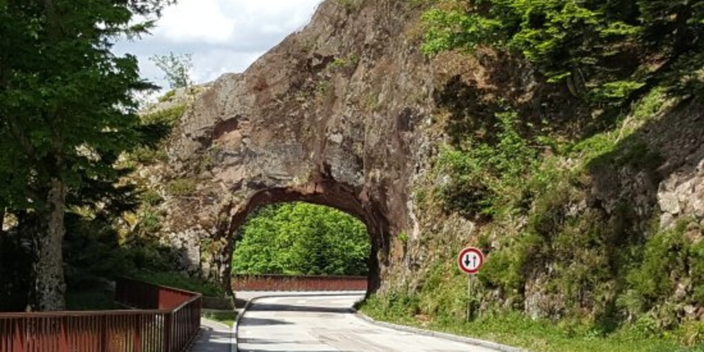
I've deviated slightly from the original route to include the natural bridge "Roche du Diable," the Devil's Stone. There's a small parking lot, a shop, and a lookout point with a beautiful view.
Follow the D61 "Le route de Crêtes," a beautiful route along the mountain ridges in Alsace. This narrow but scenic two-lane road winds partly through forests with beautiful views.
You'll drive past Lac Blank, where you should definitely stop to enjoy the beautiful mountain lake and the surrounding mountains. The next section has many bends and opportunities to stop at small parking areas to enjoy the view.
From Col de la Schlucht, you'll rejoin the Route des Crêtes, this time heading south. This last section is approximately 50 kilometers long, very winding, and a fantastic drive. There are many sights along the way. They're listed as points of interest, and if you have the time, it's definitely worth stopping and enjoying the views. I've included a link to a YouTube video with footage of the region and the Route des Crêtes.
Our lunch stop is the Hohneck mountain peak. At 1,364 meters, it's the third-highest peak in the Vosges Mountains after the Grand Ballon and the Storkenkopf. It lies on the border of Alsace and Lorraine. On the mountain, there's a mountain hut with a restaurant for lunch, a small shop, and a beautiful hiking trail.
Enjoy a ride up the Grand Ballon, the highest mountain in the Vosges Mountains. The mountain rises to 1,424 meters in the southern part of the ridge. The Grand Ballon is located in the Ballons des Vosges Natural Park, and its summit is just above the treeline.
The final stretch to Cernay is a challenging one with many twists and turns, and the occasional hairpin bend. Once again, there are stunning views of the mountains and valleys.
In Cernay, you can stay overnight in one of the hotels or at Camping Les Cigognes. Points of interest and links have been added.

 Links
Links  Usage
Usage Want to download this route?
You can download the route for free without MyRoute-app account. To do so, open the route and click 'save as'. Want to edit this route?
No problem, start by opening the route. Follow the tutorial and create your personal MyRoute-app account. After registration, your trial starts automatically.  Disclaimer
Use of this GPS route is at your own expense and risk. The route has been carefully composed and checked by a MyRoute-app accredited RouteXpert for use on TomTom, Garmin and MyRoute-app Navigation.
Changes may nevertheless have occurred due to changed circumstances, road diversions or seasonal closures. We therefore recommend checking each route before use.
Preferably use the route track in your navigation system. More information about the use of MyRoute-app can be found on the website under 'Community' or 'Academy'.

Grand Est
About this region
Grand Est (French: [ɡʁɑ̃t‿ɛst] (listen); Alsatian: Grossa Oschta; Moselle Franconian/Luxembourgish: Grouss Osten;
Rhine Franconian: Groß Oschte; German: Großer Osten [ˈɡʁoːsɐ ˈʔɔstn̩]; English: "Greater East") is an administrative region in Northeastern France. It superseded three former administrative regions, Alsace, Champagne-Ardenne and Lorraine, on 1 January 2016 under the provisional name of Alsace-Champagne-Ardenne-Lorraine (pronounced [alzas ʃɑ̃paɲ aʁdɛn lɔʁɛn]; ACAL or, less commonly, ALCA), as a result of territorial reform which had been passed by the French Parliament in 2014.The region sits astride three water basins (Seine, Meuse and Rhine), spanning an area of 57,433 km2 (22,175 sq mi), the fifth largest in France; it includes two mountain ranges (Vosges and Ardennes). It shares borders with Belgium, Luxembourg, Germany and Switzerland. As of 2017, it had a population of 5,549,586 inhabitants. The prefecture and largest city, by far, is Strasbourg.
The East of France has a rich and diverse culture, being situated at a crossroads between the Latin and Germanic worlds. This history is reflected in the variety of languages spoken there (Alsatian, Champenois, and Lorraine Franconian). Most of today's Grand Est region was considered "Eastern" as early as the 8th century, when it constituted the southern part of the Francian territory of Austrasia. The city of Reims (in Champagne), where Frankish king Clovis I had been baptized in 496 AD, would later play a prominent ceremonial role in French monarchical history as the traditional site of the coronation of the kings of France. The Champagne fairs played a significant role in the economy of medieval Europe as well. Alsace and Lorraine thrived in the sphere of influence of the Holy Roman Empire for most of the Middle Ages and Renaissance, and subject to competing claims by France and German over the centuries.
The region has distinctive traditions such as the celebration of Saint Nicholas Day, Christmas markets, or traditions involving the Easter hare in Alsace and Lorraine. Alsace-Moselle are furthermore subject to local law for historical reasons. With a long industrial history and strong agriculture and tourism (arts, gastronomy, sightseeing), the East of France is one of the top economic producing regions in the country.
Read more on Wikipedia
Rhine Franconian: Groß Oschte; German: Großer Osten [ˈɡʁoːsɐ ˈʔɔstn̩]; English: "Greater East") is an administrative region in Northeastern France. It superseded three former administrative regions, Alsace, Champagne-Ardenne and Lorraine, on 1 January 2016 under the provisional name of Alsace-Champagne-Ardenne-Lorraine (pronounced [alzas ʃɑ̃paɲ aʁdɛn lɔʁɛn]; ACAL or, less commonly, ALCA), as a result of territorial reform which had been passed by the French Parliament in 2014.The region sits astride three water basins (Seine, Meuse and Rhine), spanning an area of 57,433 km2 (22,175 sq mi), the fifth largest in France; it includes two mountain ranges (Vosges and Ardennes). It shares borders with Belgium, Luxembourg, Germany and Switzerland. As of 2017, it had a population of 5,549,586 inhabitants. The prefecture and largest city, by far, is Strasbourg.
The East of France has a rich and diverse culture, being situated at a crossroads between the Latin and Germanic worlds. This history is reflected in the variety of languages spoken there (Alsatian, Champenois, and Lorraine Franconian). Most of today's Grand Est region was considered "Eastern" as early as the 8th century, when it constituted the southern part of the Francian territory of Austrasia. The city of Reims (in Champagne), where Frankish king Clovis I had been baptized in 496 AD, would later play a prominent ceremonial role in French monarchical history as the traditional site of the coronation of the kings of France. The Champagne fairs played a significant role in the economy of medieval Europe as well. Alsace and Lorraine thrived in the sphere of influence of the Holy Roman Empire for most of the Middle Ages and Renaissance, and subject to competing claims by France and German over the centuries.
The region has distinctive traditions such as the celebration of Saint Nicholas Day, Christmas markets, or traditions involving the Easter hare in Alsace and Lorraine. Alsace-Moselle are furthermore subject to local law for historical reasons. With a long industrial history and strong agriculture and tourism (arts, gastronomy, sightseeing), the East of France is one of the top economic producing regions in the country.
View region
 Statistics
  83
83Amount of RX reviews (Grand Est)
 41824
41824Amount of visitors (Grand Est)
 14085
14085Amount of downloads (Grand Est)
 Route Collections in this region
 25 Magnificent trails in France
This MRA route collection contains 25 beautiful motorcycle routes in different parts of France, such as the Ardennes, the Alsace, Vercors, the Drôme, the Ardèche, Cote d'Azure, Gorges du Verdon, the Ariège, the Dordogne and Brittany.
The routes have been carefully created by Bert Loorbach, who is an enthusiastic motorcyclist himself. He lived in France for a year and a half, during which time he devoted himself to mapping the unknown and beautiful back roads of France especially for motorcyclists.
The routes are bundled in the Motortourgids France part 1 of Kosmos publishing house and now also available in MyRouteApp.
I have taken over the routes in MRA and sometimes adjusted them slightly to make them even more interesting for the motorcyclist.
View Route Collection
11 day trip from the Netherlands
8 countries in 11 days; The Netherlands, Germany, Austria, Italy, Switzerland, France, Luxembourg and Belgium. This route collections consists of 10 routes that I have driven with friends in the summer of 2019.
The start is in Geldermalsen Netherlands, the first 7 days you drive through the Netherlands, Germany, Austria, Italy, Switzerland, France and a piece of Luxembourg with overnight stays in hotels.
The last three days you stay in Barweiler (D) in the Eifel and you drive two beautiful tours through the Eifel, Luxembourg and parts of the Belgian Ardennes.
There is no highway in the routes, only beautiful provincial and country roads, many beautiful passes with beautiful panoramas.
Be sure to check whether the passes are open before you leave.
These are routes for experienced drivers.
View Route Collection