Curves of the Vosges Mountains MEDIUM

This route was brought to you by:
RouteXpert Guy Heyns - Sr RouteXpert
Last edit: 10-12-2024
 Route Summary
 So we are talking about the Curves of the Vosges Mountain route, Medium version.
Spicy enough to please the experienced hands, yet palatable to the rest of us.
That's where the 'medium' routes go; everyone will find something to their liking and no one will complain about it, on the contrary...
So, alone or in a club, have fun for everyone on yet another route that deserves the full five stars AB-SO-LUT.
 Share this route


Animation

Verdict


Duration
7h 37m

Mode of travel
Car or motorcycle

Distance
299.73 km

Countries

 RouteXpert Review
 The ridge that remained formed the border between France and Germany from 1871 to 1918. 1918, you read that right. The end of the First World War. Afterwards, boundaries were literally shifted, but you can already imagine that the terrain of the Vosges during WW I was a particularly turbulent area…
Not only will you cross the most important part of the famous Vosges with this medium version curves route, you will also pass 80 pins and 22 cols along the most beautiful part of the Route des Crêtes, a road that - if only it is mentioned - the water in many people's mouths...
The Vosges are a fantastic playground that, in addition to the beautiful natural beauty, also carries a wealth of tragedy and history.
Once upon a time, the roads, forests and mountains here literally turned blood red, unfortunately not always out of necessity, but to feed sad egos. People were literally sacrificed here… A little respect for the region is perhaps in order because, not so long ago, people fought to the death for freedom, equality and fraternity.
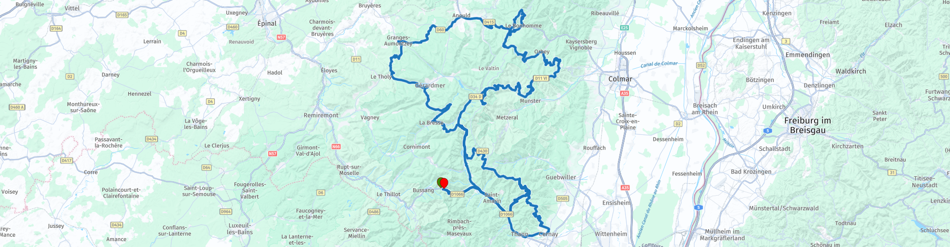
This Medium version of the curve route again departs from Motohotel Col de Bussang. Shortly after departure you will have the option to fill up your tank which might not be a bad idea on this 287km route.
After a long track, perhaps somewhat boring compared to the rest of the route, you will arrive in Cerney, the place where the Route des Crêtes, or literally translated “the ridge route”, starts at Sainte-Marie-aux-Mines in the north. The route des Crêtes spans 73 kilometers of pure beauty. Characteristic landscapes from the Vosges alternate with unique vistas that reach into the Alps and take your breath away.
The road was built in 1914 by the French army on the western side of this ridge in the Vosges. This ridge still forms the border between the regions of Alsace and Lorraine, but in the period 1871-1918 the ridge was also the border between France and Germany. After the first world war, the borders were shifted and today the Rhine forms the new border between the two countries. The road built over this ridge served to supply French troops during the First World War and you can imagine that it was the scene of many bloody battlefields in this war.
You may mark the Route des Crêtes three times on this route, but you will not complete it completely. If you want to fully enjoy the Route des Crêtes, we strongly recommend the nearby route collection 'Route des Crêtes SM-XXL'. This route collection is especially focused on this famous road and allows you to 'tast' this road to the extreme.
On this route we make bends and at the start of the Route des Crêtes, when you 'drive up' the ridge it is immediately pricey, a number of nice bends warm up the tires quickly after the passage through Cernay.
However, these tapes bring you back to a serene stop a little further to let the seriousness, tragedy and futility of war sink in for a moment. Here you will find the immense cemetery of Hartmannswillerkopf, a place where many a soldier died an inglorious and above all senseless death. Here they fought hard for a rocky peak at a height, only to caress a few egos who did not allow each other the daylight in the eyes. Please take a moment. It will get to you pretty quickly…
Another break point can also be found a little further away. You'll barely be back in the saddle, but a short stop on the Grand Ballon, the highest mountain in the Vosges, is simply a 'must-do'. Enjoy the views in good weather. In the most ideal conditions, you can even see as far as Mont Blanc, which is 'only' 230 km away….
26 kilometers further we stop again on the Route des Crêtes to give you a view on the Hohneck of that other beautiful part of the Vosges, the valley in which the Rhine has found its way.
Here you can expect a playful wink with a cup of coffee and in clear weather from that other playground in Germany that, together with the Vosges, competes for the favor of all those motorcyclists… After all, the Black Forest can rightly be called the equal neighbor of this playful Vosges.
Pretty soon after the Hohneck, near the Col de la Schlucht, we leave the Route des Crêtes again to pull out all the stops (and the throttle) on the most beautiful kilometers of this route…. Your bands will be happy to cool off at Lac Blanc or at the Col de Bonhomme where, like the bands, you might want to catch your breath. After all, the frequency & sequence of the bends around the famous 'Gazon du Faing' will not only demand the utmost from your rubbers, but also from your steering skills. The pleasure of motorcycling takes on a completely different dimension here….
On the Col de Bonhomme you can take a reduced route in bad weather by turning left instead of right. You always stay on the route, but you have pinched off about 17 kilometers…. But when the conditions are good, we take another playful loop and then drive a 'cool down' session on particularly beautiful roads. Rightly so by Michelin with a 'green' wreath decorated…
A number of small teasing curves will soon demand your attention again and you can sharpen them again. Very soon, the Lac de Gérardmer, the largest natural lake in the Vosges and a huge tourist attraction, both in summer and winter, will please your retina. Very nice to see! Even in winter, the view of the lake from the ski slopes must be truly sublime…
Shortly after Gérardmer you pass La Bresse and the 'little Moselle' or the Moselette, a tributary of its big brother.
By crossing the Moselette you immediately enter the bends Valhalla again and the first pegs present themselves again in preparation for the very cozy 'Bramont', which should of course not be missed in a curve route through the Vosges.
After the Bramont, a very cozy meander through the Forêt Communale de Kruth takes you back to the Route des Crêtes, which you follow this time in reverse direction towards the 'Ballon'. However, you leave the Route des Crêtes just before the 'Ballon' to look for the penultimate twists and turns towards the hotel. If desired, you can fill the tank again at the same gas pump as after the start before you look up the cosiness of the Hotel Col de Bussang again.
Like the other routes in this curve collection of the Vosges, this route is a gem in terms of better cornering. She allows experts to fully enjoy, while still leaving enough room for others to push boundaries towards this expert status. For that reason alone, this route is more than worthy of its five stars. And then we haven't even weighed in on the excellent asphalt, nature and breathtaking views.
A gem to enjoy… also recommended with a (sneaky) smile by your tire dealer…


 Links
Links  Usage
Usage Want to download this route?
You can download the route for free without MyRoute-app account. To do so, open the route and click 'save as'. Want to edit this route?
No problem, start by opening the route. Follow the tutorial and create your personal MyRoute-app account. After registration, your trial starts automatically.  Disclaimer
Use of this GPS route is at your own expense and risk. The route has been carefully composed and checked by a MyRoute-app accredited RouteXpert for use on TomTom, Garmin and MyRoute-app Navigation.
Changes may nevertheless have occurred due to changed circumstances, road diversions or seasonal closures. We therefore recommend checking each route before use.
Preferably use the route track in your navigation system. More information about the use of MyRoute-app can be found on the website under 'Community' or 'Academy'.

Grand Est
About this region
Grand Est (French: [ɡʁɑ̃t‿ɛst] (listen); Alsatian: Grossa Oschta; Moselle Franconian/Luxembourgish: Grouss Osten;
Rhine Franconian: Groß Oschte; German: Großer Osten [ˈɡʁoːsɐ ˈʔɔstn̩]; English: "Greater East") is an administrative region in Northeastern France. It superseded three former administrative regions, Alsace, Champagne-Ardenne and Lorraine, on 1 January 2016 under the provisional name of Alsace-Champagne-Ardenne-Lorraine (pronounced [alzas ʃɑ̃paɲ aʁdɛn lɔʁɛn]; ACAL or, less commonly, ALCA), as a result of territorial reform which had been passed by the French Parliament in 2014.The region sits astride three water basins (Seine, Meuse and Rhine), spanning an area of 57,433 km2 (22,175 sq mi), the fifth largest in France; it includes two mountain ranges (Vosges and Ardennes). It shares borders with Belgium, Luxembourg, Germany and Switzerland. As of 2017, it had a population of 5,549,586 inhabitants. The prefecture and largest city, by far, is Strasbourg.
The East of France has a rich and diverse culture, being situated at a crossroads between the Latin and Germanic worlds. This history is reflected in the variety of languages spoken there (Alsatian, Champenois, and Lorraine Franconian). Most of today's Grand Est region was considered "Eastern" as early as the 8th century, when it constituted the southern part of the Francian territory of Austrasia. The city of Reims (in Champagne), where Frankish king Clovis I had been baptized in 496 AD, would later play a prominent ceremonial role in French monarchical history as the traditional site of the coronation of the kings of France. The Champagne fairs played a significant role in the economy of medieval Europe as well. Alsace and Lorraine thrived in the sphere of influence of the Holy Roman Empire for most of the Middle Ages and Renaissance, and subject to competing claims by France and German over the centuries.
The region has distinctive traditions such as the celebration of Saint Nicholas Day, Christmas markets, or traditions involving the Easter hare in Alsace and Lorraine. Alsace-Moselle are furthermore subject to local law for historical reasons. With a long industrial history and strong agriculture and tourism (arts, gastronomy, sightseeing), the East of France is one of the top economic producing regions in the country.
Read more on Wikipedia
Rhine Franconian: Groß Oschte; German: Großer Osten [ˈɡʁoːsɐ ˈʔɔstn̩]; English: "Greater East") is an administrative region in Northeastern France. It superseded three former administrative regions, Alsace, Champagne-Ardenne and Lorraine, on 1 January 2016 under the provisional name of Alsace-Champagne-Ardenne-Lorraine (pronounced [alzas ʃɑ̃paɲ aʁdɛn lɔʁɛn]; ACAL or, less commonly, ALCA), as a result of territorial reform which had been passed by the French Parliament in 2014.The region sits astride three water basins (Seine, Meuse and Rhine), spanning an area of 57,433 km2 (22,175 sq mi), the fifth largest in France; it includes two mountain ranges (Vosges and Ardennes). It shares borders with Belgium, Luxembourg, Germany and Switzerland. As of 2017, it had a population of 5,549,586 inhabitants. The prefecture and largest city, by far, is Strasbourg.
The East of France has a rich and diverse culture, being situated at a crossroads between the Latin and Germanic worlds. This history is reflected in the variety of languages spoken there (Alsatian, Champenois, and Lorraine Franconian). Most of today's Grand Est region was considered "Eastern" as early as the 8th century, when it constituted the southern part of the Francian territory of Austrasia. The city of Reims (in Champagne), where Frankish king Clovis I had been baptized in 496 AD, would later play a prominent ceremonial role in French monarchical history as the traditional site of the coronation of the kings of France. The Champagne fairs played a significant role in the economy of medieval Europe as well. Alsace and Lorraine thrived in the sphere of influence of the Holy Roman Empire for most of the Middle Ages and Renaissance, and subject to competing claims by France and German over the centuries.
The region has distinctive traditions such as the celebration of Saint Nicholas Day, Christmas markets, or traditions involving the Easter hare in Alsace and Lorraine. Alsace-Moselle are furthermore subject to local law for historical reasons. With a long industrial history and strong agriculture and tourism (arts, gastronomy, sightseeing), the East of France is one of the top economic producing regions in the country.
View region
 Statistics
  86
86Amount of RX reviews (Grand Est)
 42825
42825Amount of visitors (Grand Est)
 14396
14396Amount of downloads (Grand Est)
 Route Collections in this region
 25 Magnificent trails in France
This MRA route collection contains 25 beautiful motorcycle routes in different parts of France, such as the Ardennes, the Alsace, Vercors, the Drôme, the Ardèche, Cote d'Azure, Gorges du Verdon, the Ariège, the Dordogne and Brittany.
The routes have been carefully created by Bert Loorbach, who is an enthusiastic motorcyclist himself. He lived in France for a year and a half, during which time he devoted himself to mapping the unknown and beautiful back roads of France especially for motorcyclists.
The routes are bundled in the Motortourgids France part 1 of Kosmos publishing house and now also available in MyRouteApp.
I have taken over the routes in MRA and sometimes adjusted them slightly to make them even more interesting for the motorcyclist.
View Route Collection
11 day trip from the Netherlands
8 countries in 11 days; The Netherlands, Germany, Austria, Italy, Switzerland, France, Luxembourg and Belgium. This route collections consists of 10 routes that I have driven with friends in the summer of 2019.
The start is in Geldermalsen Netherlands, the first 7 days you drive through the Netherlands, Germany, Austria, Italy, Switzerland, France and a piece of Luxembourg with overnight stays in hotels.
The last three days you stay in Barweiler (D) in the Eifel and you drive two beautiful tours through the Eifel, Luxembourg and parts of the Belgian Ardennes.
There is no highway in the routes, only beautiful provincial and country roads, many beautiful passes with beautiful panoramas.
Be sure to check whether the passes are open before you leave.
These are routes for experienced drivers.
View Route Collection