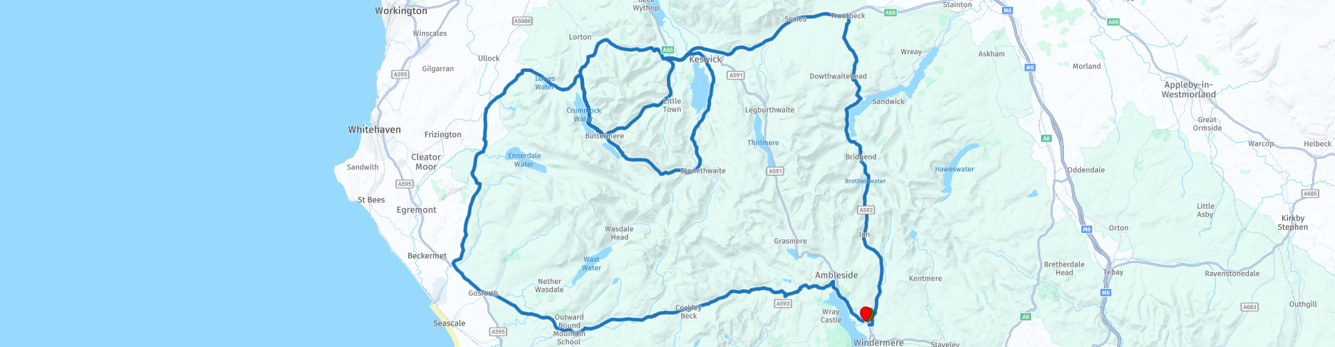
The Lake District Passes Anti Clockwise

This route was brought to you by:
RouteXpert Nick Carthew - (MRA Master)
Last edit: 11-03-2025
 Route Summary
  Share this route


Animation

Verdict


Duration
7h 18m

Mode of travel
Car or motorcycle

Distance
181.39 km

Countries

 RouteXpert Review
 The passes are in this order:
Kirkstone Pass.
Whinlatter Pass.
Honister Pass.
Newlands Pass.
Hardknott Pass.
Wrynose Pass.
Kirkstone Pass with an altitude of 1,489 feet is the Lake District’s highest pass that is open to motor traffic. The road follows the route of a drover's road, used by farmers. Overall, Kirkstone Pass offers a scenic and memorable drive through the heart of the Lake District and is a popular route for tourists and motorists exploring the area.
Whinlatter Pass winds its way through the Thornthwaite Forest, to a height of 1,043 feet above sea level. It is the northernmost of all the passes and has a Forestry Commission Visitor Centre along it.
Honister pass starts at Gatesgarth Farm, at the southern end of Buttermere. It connects the Buttermere valley with the eastern end of Borrowdale valley. Rising to 1167 feet in height at the summit, it is one of Cumbria’s highest passes, with a gradient of 1 in 4. Slate mining has taken place in the Lake District for 100s of years and the last remaining mine in England is at Honister Pass. You can stop here and check out the gift shop.
Newlands Pass is a three-mile-long road running along a ledge above the Newlands valley. The highest point is Newlands Hause, 333 metres (1093 feet), where there is a car park, and a great view of the Moss Force waterfall.
Hardknott Pass is the trickiest with tight bends on a bumpy surface all at a 30% gradient, the views from the top are well worth the effort though. The pass is described as one of the most challenging roads in Britain and shares the title of steepest road in England with Rosedale Chimney Bank in Yorkshire. There are some good remains of a Roman fort before the climb up Hardknott really begins .
Wrynose Pass follow the River Duddon to where it rises, close to the summit of the Wrynose Pass, here you'll see the Three Shire Stone, marking the meeting point of the historic counties of Cumberland, Lancashire and Westmorland. The name "Wrynose" stems from the phrase 'pass of the stallion,' alluding to the steep gradients that necessitated a robust horse to ascend to the summit.
Lunch stop is in Keswick. This is a secure motorcycle park at the back of Oddfellows Arms where we had a superb lunch there but you are surrounded with other places to eat and drink if you prefer.
The Lake District Passes has to be on everyone's list of places to visit and each pass is completely different if ridden in the opposite direction. The whole of the Lake District is full of beautiful roads to ride and around every corner is another fantastic view.
For those of you who would like a reversed copy of this route, I have added one to the MyRoute-app RouteXpert Library and titled it: The Lake District Passes Clockwise. See the link for this below.


 Links
Links  Usage
Usage Want to download this route?
You can download the route for free without MyRoute-app account. To do so, open the route and click 'save as'. Want to edit this route?
No problem, start by opening the route. Follow the tutorial and create your personal MyRoute-app account. After registration, your trial starts automatically.  Disclaimer
Use of this GPS route is at your own expense and risk. The route has been carefully composed and checked by a MyRoute-app accredited RouteXpert for use on TomTom, Garmin and MyRoute-app Navigation.
Changes may nevertheless have occurred due to changed circumstances, road diversions or seasonal closures. We therefore recommend checking each route before use.
Preferably use the route track in your navigation system. More information about the use of MyRoute-app can be found on the website under 'Community' or 'Academy'.