Day 08 of 12 Day Roadtrip Iceland Blonduos Reykholar

This route was brought to you by:
RouteXpert René Plücken (MRA Master)
Last edit: 12-02-2021
 Route Summary
 Driving in Iceland is a great experience whether you travel by car or as described in this review by motorcycle.
These routes are based on information about Iceland that you can find on the Internet, especially from the Guide to Iceland, where you can find a wealth of information to prepare you well for your trip. The material on this site has been compiled with great care, the link can be found in the review of the first route in this series.
You drive through landscapes that are varied and beautiful, you see glacier tongues, volcanic mountains, geothermal areas with active geysers, lava fields, craters, forests, waterfalls and incredibly rugged stretches of coast.
The routes in the north are part of the 'Arctic Coast Way'.
The main roads are of good quality but you also drive a lot on gravel roads, so not suitable for road motorcycles. Some of these roads are sometimes closed due to the weather. It is therefore important that you check the weather forecasts and the situation of the roads every day before you leave, this information can be found on the website of "Icelandic Meteorological Office" and for the roads on the website of "The Icelandic Road and Coastal Administration" " The links are in the review.
Due to the Icelandic climate, this trip can only be made in the summer.
 Share this route


Animation

Verdict


Duration
5h 18m

Mode of travel
Car or motorcycle

Distance
326.99 km

Countries

 RouteXpert Review
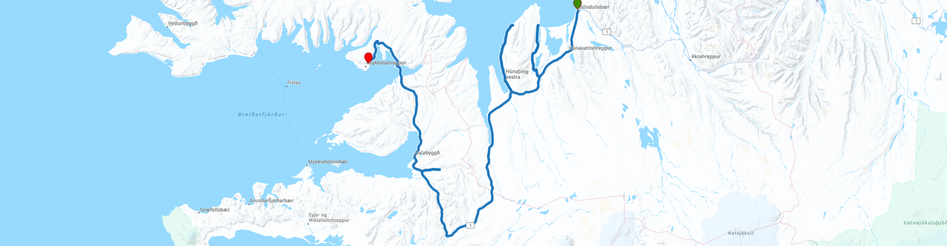
 If you take the exit from Route 1 to Route 716 and follow this road to Route 711, you will arrive at Vatnsnes. As soon as you reach the ocean you will see the bizarre 15-meter-high Hvítserkur (RP3) formation; some believe it looks like an elephant, others a dragon and others a troll. You can approach the coastline on foot for your chance to shoot it.
We continue on Route 711, you have a beautiful view of the steep coast. The Vatnsnes peninsula is the most reliable place in Iceland to spot seals, so even if you haven't seen one in Jökulsárlón (Day 3) or the Eastern Fjords, you can certainly see a few today.
At RP4 you can visit Illugastaðir, this is a historic farm where farmer and herbalist Natan Ketilsson was murdered in 1828 and that led to the last execution in. This is also an ideal place to spot seals
For more information about the seals of Iceland, in terms of their biology, distribution and historical relationship with people, you can visit the Icelandic seal center in Hvammstangi (RP6). This beautiful coastal town also has various shops and restaurants and options for refueling.
Once you've enjoyed the Vatnsnes peninsula, your journey to the Reykhólar begins where we spend the night. This is a beautiful road through the rugged landscape of Iceland where the Route 60 treats you with wonderful curves through the rolling landscape.
At RP8 we visit Eiríksstaðir, the former home and museum of Eiríkr Þorvaldsson, known as Erik the Red, in Haukadalur in the Dalasýsla region in Iceland. It was the birthplace of his son Leif Eiríksson, America's first well-known European discoverer.
Then we continue the journey along the Gildsfjordur to the end point in Reykhólar.
I rate this route with 4 **** Stars, it is a beautiful route with beautiful panoramas along the fjords and some nice sights.


 Links
Links  Usage
Usage Want to download this route?
You can download the route for free without MyRoute-app account. To do so, open the route and click 'save as'. Want to edit this route?
No problem, start by opening the route. Follow the tutorial and create your personal MyRoute-app account. After registration, your trial starts automatically.  Disclaimer
Use of this GPS route is at your own expense and risk. The route has been carefully composed and checked by a MyRoute-app accredited RouteXpert for use on TomTom, Garmin and MyRoute-app Navigation.
Changes may nevertheless have occurred due to changed circumstances, road diversions or seasonal closures. We therefore recommend checking each route before use.
Preferably use the route track in your navigation system. More information about the use of MyRoute-app can be found on the website under 'Community' or 'Academy'.