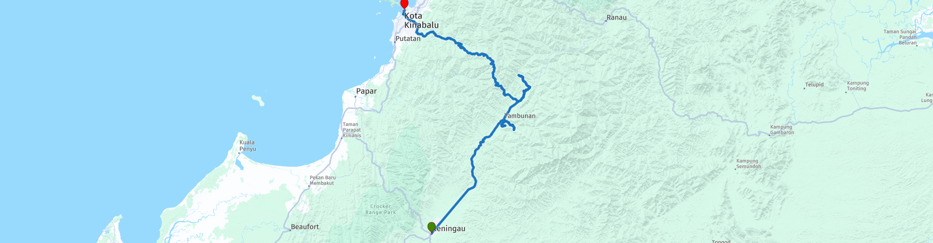
Day 11 Sabah Road Trip Keningau Tambunan Penampang Kota Kinabalu

This route was brought to you by:
RouteXpert René Plücken (MRA Master)
Last edit: 12-04-2021
 Route Summary
 This route was created with his permission.
Seen as one of the most beautiful provinces in Malaysia, Sabah is known for its scenic landscape with spectacular mountains, beautiful beaches, surreal sunsets, rich culture, friendliest people, winding roads, tall waterfalls, national parks and much more!
The roads in Malaysia are generally in good condition, but beware; there are also parts where the asphalt is poor and there can be potholes in the road surface. This can be dangerous, so caution is advised. During the rainy season (September-December) the roads can be slippery. Traffic in Malaysia drives on the left side of the road.
You can rent a motorcycle in Malaysia, but these are usually lighter models and often scooters. You can spend the night in hotels, B & Bs or campsites, which can easily be booked via the website in the review or via booking.com.
I rate this route with 5 ***** stars because of the beautiful roads, the beautiful nature, sights that you can visit.
 Share this route


Animation

Verdict


Duration
8h 27m

Mode of travel
Car or motorcycle

Distance
177.52 km

Countries

 RouteXpert Review
 The first stop is at the Sinurambi Tambunan (Tambunan Viewing Point), for this you have to drive straight ahead at RP2 and drive about 3½ kilometers on an unpaved road. Note, the HERE map does not know this way and tries to steer you via a different route.
Tambunan Viewing Point (RP4) looks like a Wakid, a traditional bamboo basket from Sabah, The Tambunan Viewing Point (also known as Sinurambi Tower and Pongimpaan Nuluhon Dandab) is built on Trig Hill with a panoramic view of the green Tambunan valley. From the city of Tambunan, this 14 meter high (about 14 meter) tower looks like a huge basket left on a hill by a giant one, it's quite a prominent landmark.
You drive the same way back to Tambunan where we drive towards the next point.
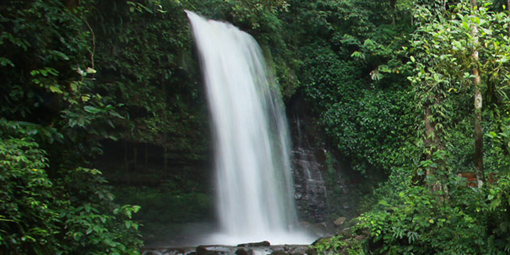
A must see in Sabah is the Mahua Waterfall at RP5 (Malay: Air Terjun Mahua). After a short walk you will come to a plunge-type waterfall in Patau Village. The waterfall has a height of 17 meters (56 ft) with a depth of 1.2 meters. The waterfall is one of the eco-tourist attractions for this area.
We drive the same way back to Tambunan to enter the Crocker Range National Park. We stop briefly at the Mosakob waterfall (RP6) to take a picture. Less spectacular than the Mahua waterfall, but well worth it for a short stop.
After about 2½ kilometers we stop at The Rafflesia Information Center (RP6). This is a lesser known center, but it is probably the best place to see the rare rafflesia flower while in Sabah.
The center is only open Monday through Saturday from 8:00 am to 3:00 pm. The center has sufficient plots and flower buds which increase the chances of seeing a Rafflesia.
With or without a blooming Rafflesia, the center is a great starting point for exploring Sabah's beautiful Crocker Range National Park. The Crocker Range National Park has a lot to offer, but is less visited compared to the Kinabalu National Park. The steep terrain in the park is home to a diverse range of flora and fauna and is also very busy during the high season.
The Rafflesia is one of the rarest and strangest flowers in the world. It is undeniably the largest you can find in the world as it weighs up to 22 pounds and looks quite otherworldly.
It is actually a parasite that can be hosted by only one vine in the world. Rafflesia is only found in Sumatra, Java, Peninsular Malaysia, Borneo and the Philippines. The flower smells like rotting flesh at the end of its life cycle to attract flies and other insects.
The flower only blooms for three to five days. The chance to see one bloom requires some luck and good timing.
You can stay overnight in the Crocker Range National Park if you want to plan a longer visit. The accommodation is dorm style, so be prepared for bunk beds.
Lunch is scheduled at Gunung Alab Resort (RP8) which is a two-story building. There is a restaurant and a small grocery store on the ground floor. The hotel rooms are on the second floor. You are here at an altitude of 1650 meters and it can be cold and foggy.
After lunch we drive on the “500”, this road meanders through the Crocker Range National Park, it is a two lane road with many curves that winds through the beautiful green park. Keep in mind that it can be foggy and you have reduced visibility.
At RP10 we stop at the beautifully scenic Kipandi Butterfly, which is 700 meters high and is rich in entomofauna. In the Kipandi Butterfly Park they have more than 1,500 butterfly samples, more than 100 species of butterflies, including Troides Brookiana (Raja Brook's Birding) and Troides Amphrysus (Golden Birding).
More than 3,000 beetles including endemic species found only in the Crocker Range, such as Cyclommatus Chewi. As many as 500 types of native orchids, 40 types of Hoyas, 5 types of lipstick flowers and 28 types of “carnivorous” pitcher and medicinal plants. Special fences have also been built to house some of the rare and endangered species of Sabahan orchids and pitcher plants.
After this it is a little less than 40 kilometers to the end point in Kota Kinabalu, where we return the rental bike to the rental company.

 Links
Links  Usage
Usage Want to download this route?
You can download the route for free without MyRoute-app account. To do so, open the route and click 'save as'. Want to edit this route?
No problem, start by opening the route. Follow the tutorial and create your personal MyRoute-app account. After registration, your trial starts automatically.  Disclaimer
Use of this GPS route is at your own expense and risk. The route has been carefully composed and checked by a MyRoute-app accredited RouteXpert for use on TomTom, Garmin and MyRoute-app Navigation.
Changes may nevertheless have occurred due to changed circumstances, road diversions or seasonal closures. We therefore recommend checking each route before use.
Preferably use the route track in your navigation system. More information about the use of MyRoute-app can be found on the website under 'Community' or 'Academy'.