TTT 2015 07 Den Bosch Oirschot

This route was brought to you by:
RouteXpert Hans van de Ven (Mr.MRA)
Last edit: 21-04-2021
 Route Summary
 The 173 ANWB Promoter TankTasTocht (TTT) were scanned by Henry ten Dam and signed by Leon Stolk in Mapsource and later placed as a Track in a .gpx file. These have been made available through the MrGPS website with the approval of the ANWB Promoter so that everyone can enjoy it. The 1st TTT is from 1992, so the route may differ slightly from the original.
I have checked all route points and, where necessary, placed them neatly on the road. Also, if necessary, I have further spaced the start point and end point of the route to avoid navigating directly to the end point and I added the POI files from the start and end point just like a possible stopping point.
Finally, I made the route the same for TomTom, Garmin and MyRoute-app Navigation users.
Thanks to Henry, Leon, MrGPS and Promoter.
 Share this route


Animation

Verdict


Duration
3h 49m

Mode of travel
Car or motorcycle

Distance
132.55 km

Countries

 RouteXpert Review
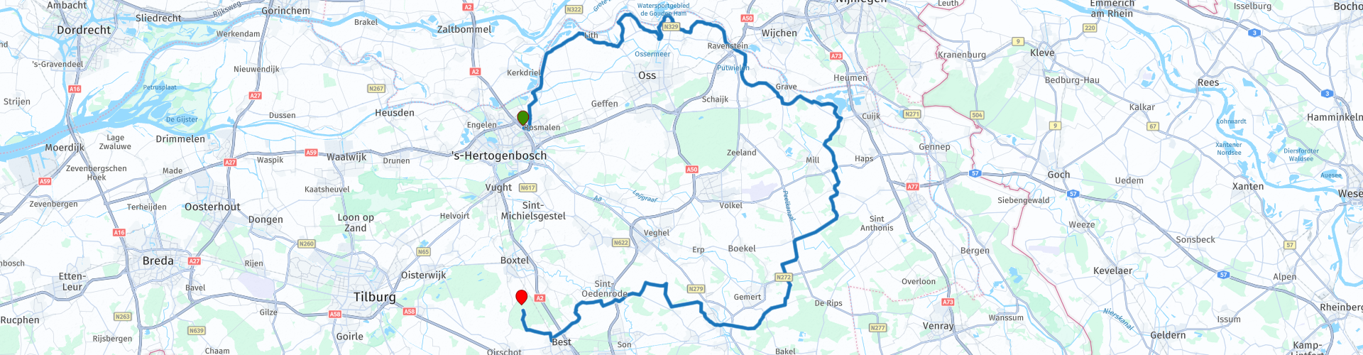
 The route winds along the Maas from the starting point in Den Bosch. You will experience why this route is so loved by motorcyclists. After 10 minutes you can take a photo of the Hertogs pumping station & Caners pumping station. After the photo you continue to swing along the mesh and you can see the photo with the Gevangenpoort in the background. The Gevangenpoort is a gate tower of the Dutch town Megen built in the 14th century. The tower was part of the wall of Megen, of which the tower is the only remnant, and served as part of an entrance gate and prison.
At Velp we ignore the mesh and go via Escharen to the Kraaijenbergse Plassen, these lakes form a vast lake area of over 400 hectares. The lakes are located in the municipalities of Cuijk and Grave. The puddles have been created since 1968 through the extraction of industrial sand, gravel and clay.
That swing makes you hungry, for that you can go to 't Raadhuis in Wanroij, you are then just over half the route.
After the stop you continue to wind between the Brabant meadows and through the Brabant villages, at Beek and Donk you pass the Zuid-Willemsvaart, this is a channel in the provinces of Dutch-Limburg, Belgian-Limburg and North-Brabant. It serves as the lateral channel of the Maas. Various other important waterways connect to it, including the other Kempian canals and the Wilhelminakanaal. After Beek en Donk you will pass through Nijnsel, Boskant and Best to close the TTT in Oirschot with 'De Schutskuil' with some goodies.
Because I have driven this route myself, this route gets 5 stars.
Route details:
rp 4 - Photo stop at the Hertogs pumping station & Caners pumping station
rp 16 - Photo stop at the Gevangenpoort in Megen
rp 31 - 't Raadhuis, lunch / coffee break in Wanroij


 Links
Links  Usage
Usage Want to download this route?
You can download the route for free without MyRoute-app account. To do so, open the route and click 'save as'. Want to edit this route?
No problem, start by opening the route. Follow the tutorial and create your personal MyRoute-app account. After registration, your trial starts automatically.  Disclaimer
Use of this GPS route is at your own expense and risk. The route has been carefully composed and checked by a MyRoute-app accredited RouteXpert for use on TomTom, Garmin and MyRoute-app Navigation.
Changes may nevertheless have occurred due to changed circumstances, road diversions or seasonal closures. We therefore recommend checking each route before use.
Preferably use the route track in your navigation system. More information about the use of MyRoute-app can be found on the website under 'Community' or 'Academy'.