Dutch tour Veluwe Dykes IJssel Gelderland

This route was brought to you by:
RouteXpert Dick Schaap
Last edit: 11-09-2021
 Route Summary
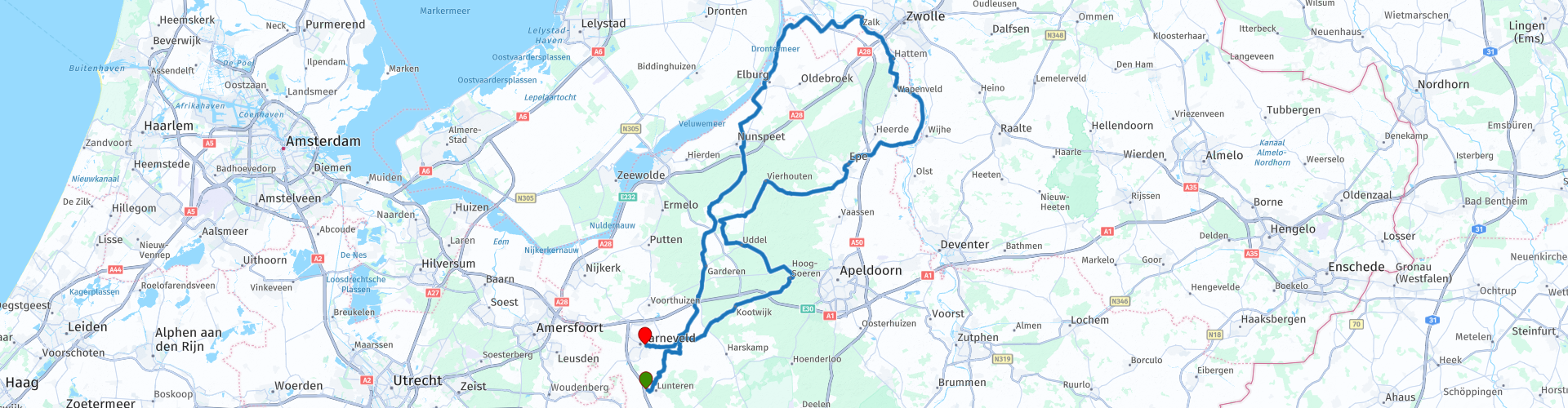
 A varied route, 172km, over the Veluwe, north Gelderland to Zwolle, back along the IJssel. Through polders, over dikes, forest, heath and fields.
Characteristics
I made and drove this route myself in the Covid-19 era and has been adjusted in such a way that the start, rest and end point are at a gas station with coffee and toilet facilities.
A good lunch address was added in 2021, "At the mill" in Hattem
Valuation
Because of the easily accessible roads and dikes, the variety in the special landscape, I rate this route with 5 stars
 Share this route


Animation

Verdict


Duration
5h 8m

Mode of travel
Car or motorcycle

Distance
172.47 km

Countries

 RouteXpert Review
 Scenically very beautiful with the Coulissen landscape around Barneveld, then a view over the Veluwe and Drontermeer with Eastern Flevoland on the other side, our pride of land reclamation from the sea. Then you drive on narrow dike roads through the polder landscape between roughly Elburg and Kampen. Then a magnificent view over the IJssel when driving over the Marle and IJsseldijk. The route returns along moors - including the well-known Aardhuisweg - and through the woods of the North Veluwe.
On the way back, after the stop Assel, there is a small piece of 2 km of unpaved road surface. The gravel layer is well broken in, so this is doable with calm driving. Keep your distance, dust bites!
I made and drove this route in the Covid-19 era so the start, end and break points are at a gas station with coffee and toilet facilities. A good lunch address was added in 2021, "Bij de Molen" in Hattem.
Start route: Esso De Stroet, Postweg 1, 6741 GB Lunteren
Lunch: Bij de Molen, Molenbelt 3A, 8051 VE Hattem
End of route: Shell, Van Zuijlen van Niveltlaan 59, 3771 AB Barneveld
The Veluwe
The Veluwe is a predominantly wooded region in the Dutch province of Gelderland and a former quarter of the Duchy of Gelre. The Veluwe measures approximately 1,000 km². In contrast to the old quarter, the Veluwe has no clearly defined fixed boundaries.
The Veluwe mainly consists of deciduous and coniferous forests. In addition, there are large sand drifts and heaths. There is also agricultural land and urban area. Several streams run through the area and there are several fens.
Hanseatic City and Museum City Vestig Elburg (Vp17)
Don't be misled by the modest size of the fortress Elburg (250 x 350 metres). You already imagine yourself in a museum as soon as you enter the fortress and then your museum tour still has to start. There is a surprising amount to discover about the history of this Hanseatic city. Not only fishing, but also other old crafts and Jewish history are central to the Elburger museums.
National monument Pouwel Bakhuis pumping station (Vp30)
Pump house of the pumping station "Pouwel Bakhuis" is of general interest because of its architectural-historical value as an example of a pump house, built in traditionalist building style. The importance lies mainly in the remarkably intact interior of the engine room with the two original centrifugal pumps. Of urban importance due to its striking location in a landscape that has historically been linked to water regulation in this area.
ESTATE STAVERDEN (Vp42)
Staverden received its city rights in 1298 from the German king Rudolph, but it never really became a real city. It is a beautiful example of a castle with a self-sufficient estate and a green legacy of centuries of aristocratic life in the Veluwe. Its size and character give Staverden its charm.
Smallest city in the Netherlands
Staverden became famous for Count Reinoud I of Gelre (1271-1326) and his ambitious plans for the village. The village was granted town status in 1298 as a form of encouragement and as a reward for its ambitions. But the development of Staverden never happened, and there has been no urban development whatsoever since then. However, Staverden has 16 farms spread across its lands; a coach house, orangery, windmill; dovecote, workers' houses, a church and a cemetery, and is officially the smallest city in the Netherlands.


 Links
Links  Usage
Usage Want to download this route?
You can download the route for free without MyRoute-app account. To do so, open the route and click 'save as'. Want to edit this route?
No problem, start by opening the route. Follow the tutorial and create your personal MyRoute-app account. After registration, your trial starts automatically.  Disclaimer
Use of this GPS route is at your own expense and risk. The route has been carefully composed and checked by a MyRoute-app accredited RouteXpert for use on TomTom, Garmin and MyRoute-app Navigation.
Changes may nevertheless have occurred due to changed circumstances, road diversions or seasonal closures. We therefore recommend checking each route before use.
Preferably use the route track in your navigation system. More information about the use of MyRoute-app can be found on the website under 'Community' or 'Academy'.