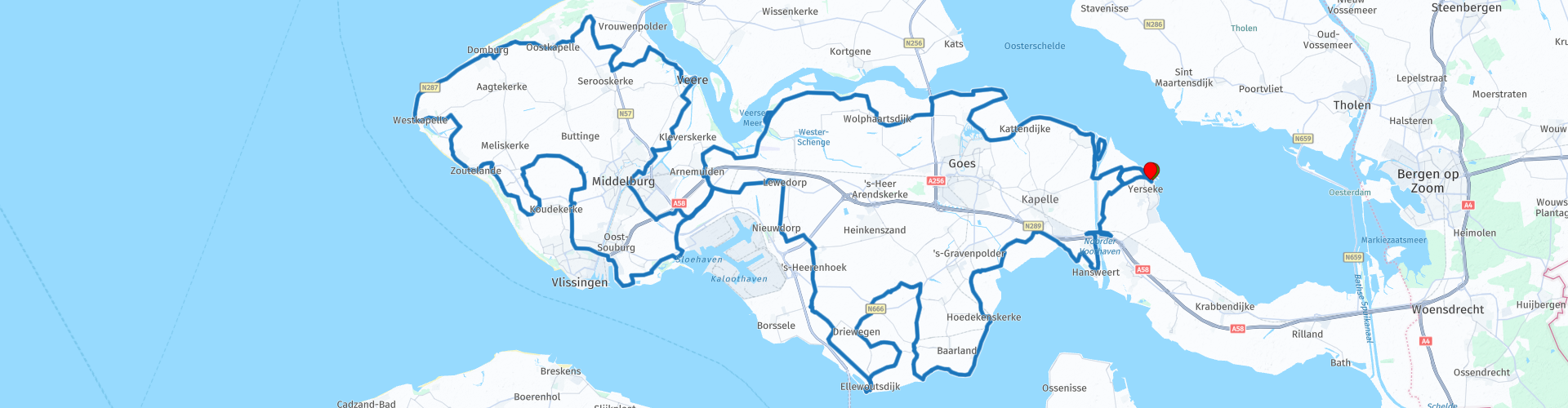
TTT 2024 01 Rondrit Walcheren vanuit Yerseke

This route was brought to you by:
RouteXpert Hans van de Ven (Mr.MRA)
Last edit: 03-05-2024
 Route Summary
 These TTT are tours through the Netherlands with an occasional trip to Belgium, Germany or even Luxembourg, which are held 6 to 7 times a year. These TTT have a starting point, a break point and an end point. It is fun to discover what you have not yet seen in your own country and which nice roads you did not know about.
This TTT may differ slightly from the original.
Thanks to Motor.nl
This 4-star rated route is always fun to drive and shows you a beautiful part of the Netherlands!
Route optimization: Fastest.
 Share this route


Animation

Verdict


Duration
8h 12m

Mode of travel
Car or motorcycle

Distance
212.59 km

Countries

 RouteXpert Review
 To drive further west you have to cross the Channel through Zuid-Beveland. This is possible via the . In the west lurks the water wolf, which is only too happy to sink its teeth into the dikes. Then it flows like the flood disaster of 1953. Survivors lost property and often had to live with family for years or in emergency barracks, such as those that were built in Hansweert, among others.
But we also owe the Delta Plan to that flood disaster. Not only a piece of construction industry at world level, but also better road connections that after 1953 connected Zeeland with the rest of the Netherlands and removed it from its isolation. A little then. Because for many motorcyclists, Zeeland feels further away than the Ardennes, the Eifel or the Sauerland. A kind of wild west. After Everdingen you drive into the Zak van Zuid-Beveland. A paradise for motorcyclists. Think of driving over high, winding dikes, lined with hedges and tall trees. Industrious Zeelanders have been crafting pieces of dike together here for centuries and this reclamation has created one of the most beautiful pieces of polder area in the Netherlands. Meadows and fruit plantations keep the view from your wheelhouse pleasantly rural. Driving on the dike, the landscape is a patchwork of fields, meadows, fruit plantations, dikes, creeks and shallow water ponds, created by dike breaches. All kinds of bird species live around these waters, such as kingfishers, grebes, red flycatchers and marsh harriers. Freedom and happiness everywhere, even among our feathered friends.
What's the Wild West without a fort? At the southernmost point of Zuid Beveland, seagulls skim over the Fort at Ellewoutsdijk. It was built in 1839 to guard the Western Scheldt, the access road to the port of Antwerp. That is why this area was also controversial during the Second World War. The Allies had already conquered Antwerp, the port was crucial for the supply of weapons and men. But the Germans were still on the north bank of the Western Scheldt, with a devilish mix of bunkers, forts, cannons and other weaponry. So Walcheren also became the scene of an Allied invasion, just like Normandy. In the autumn of 1944, the Allies landed on this coast and, after a bitter battle, managed to push the Germans back further and eventually force them to surrender.
The Zeeland Liberation Museum in Nieuwdorp is dedicated to that history. What started with one Canadian helmet grew into the impressive collection of Kees Traas and his son Stef. The collection in the indoor and outdoor museum contains more than 40,000 pieces. Real stuff, not just that modern museum stuff on screens. In dioramas and display cases. Soldier dolls in uniforms, civilian dolls in traditional costumes, period-related utensils, weapons and vehicles including, otherwise it wouldn't be a good museum, also a few Harley-Davidson Liberators and a German boxer sidecar.
Further west over the Sloedam, the bottleneck isthmus that separated Zuid Beveland from Walcheren and which was fiercely fought over during the war. Ultimately, the Germans also surrendered on Walcheren and returned to their homeland. Now our eastern neighbors are welcome bathers in Zeeland. They have a preference for the Zeeland Riviera, the coast around Zoutelande that claims the most hours of sunshine in the Netherlands, right on the Western Scheldt. Oosterschelde, Westerschelde, they are just strange names. Because they are located north and south of each other, right? The same applies to the places Oostkapelle and Westkapelle.
But what's in a name? Westkapelle is the hotspot of this Let's Go West tour and you could spend the night there. Museum Het Polderhuis has a nice outdoor terrace, the coffee is freshly brewed and the accompanying apple pie is made exclusively for Het Polderhuis by neighboring bakery Koppejan. The terrace is located in the lee of the dike and offers a view of, among other things, a Sherman tank and a landing craft from the Second World War. The museum tells more about this. Floods were caused not only by the fierce water wolf, but also by bombings. Because during the invasion of Walcheren in 1944, Allied aircraft bombed Westkapelle to drive out the German occupiers with the help of the water wolf.
The Westkapelse Zeedijk was the most famous of all Zeeland sea dykes for centuries before the Delta Works. The place where the Zeedijk collapsed due to the bombs in 1944 is still called Het Gat and tourists from all directions now enjoy the bathing beach of the same name.
Westkapelle has no fewer than two lighthouses. A classic red and white striped example outside the sea wall and the whopper, called Sint-Willibrorduskerktoren, in the middle of the village. You can go up there by elevator or via the stairs. At a height of fifty meters you can enjoy the view of the sea of orange roofs. Westkapelle was destroyed during the war and that color was somewhat obligatory during the reconstruction. Whether you are royalist or not, the orange goes well with the blue of the sea behind the roofs.
The Panoramaweg takes people and motorcycles further to Domburg, the oldest seaside resort on the Walcheren coast. The Hoge Duin also offers a beautiful view, here over the largely preserved village view, the dunes, the sea and the pile heads. These are rows of wooden poles that extend into the sea from the coast to break the force of the waves. The piles have been driven into the seabed using a hand-driven pile driver for centuries, just as traditional a job as frying a mussel burger in Yerseke and baking apple pie in Westkapelle.
After Oostkapelle, Vrouwenpolder is on the route. This is where the last German stronghold on Walcheren surrendered on November 8, 1944. In Veere, the old city center has been so beautifully preserved that you feel like you are touring around in the Middle Ages. Then you meander along the Walcheren Canal to the nearest bridge. As a result, you will be treated to the urban beauty of Middelburg.
More than a thousand old buildings have been preserved as monuments in the Zeeland capital. One of its showpieces is certainly the Zeeuws Museum. After this cultural-historical intermezzo, the isthmus of the Sloedam follows again, this time from west to east. The route continues at pleasant dike height between the Veerse Meer on port side and various polder landscapes on starboard. You arrive in Wemeldinge via Wolphaartsdijk and Wilhelminadorp. Until the eleventh century, this area was largely flooded and uninhabited. From the twelfth century onwards, Zeeland was reclaimed piece by piece, first with ring dikes around the settlements that arose, later also with dikes to protect the land reclaimed from the sea. Because the Zeeland clay turned out to be fertile and extremely suitable for agriculture. Motorcyclists, just like farmers, are of course real landlubbers. But the coast continues to work on you like a magnet. Not least because of the dike roads that meander along it. The Oude Zeedijk towards Wemeldinge scores very well.
In Wemeldinge you have to cross another bridge connection, this time over the Canal through Zuid-Beveland. It was largely dug by hand and opened in 1886 as a shipping connection between the two Scheldts. Locks were added at Wemeldinge and Hansweert, so you know them all now. In 1993 the canal was widened and diverted around Wemeldinge. The parlevinkers, traders who supplied the waiting ships in the lock from the shore and boats, had to look for other work. Wemeldinge successfully focused on tourism, the old lock chamber is now a marina.
And then Yerseke comes into view again. From the fishing harbor and the oyster pits you can once again look out to the Oosterschelde, the largest National Park in the Netherlands. Outside the dike lies a world that is constantly changing under the influence of ebb and flow, wind and water. Sandbanks, salt marshes and mud flats that dry out and disappear again under water offer just as beautiful a view as the Zeeland farmlands where clouds cast a play of light and dark with their shadows. The land east of Yerseke once had eighteen villages. But many of them drowned due to the St. Felix Flood of 1530, later also followed by Reimerswaal, one of Zeeland's three most important places at the time. Now that area is called the Drowned Land of Zuid-Beveland and the name of the current municipality of Reimerswaal, to which Yerseke also belongs, is reminiscent of that Atlantis of the Low Countries on the Sea.
Until the end of the seventeenth century, Van Reimerswaal still had an island with some ruins sticking out above the water. Those ruins then also disappeared under water. 'It is wonderful how a city that was so famous for its trade, shipping and trade has become so unknown,' wrote the historian Jacobus Ermerins in 1785. Nothing remains of the historic city of Reimerswaal in our time. Rijkswaterstaat built the Bergse Diepsluis on the site of this city in 1978 as part of the Oesterdam. And you drive back to Zeeland via that dam road.


 Links
Links  Usage
Usage Want to download this route?
You can download the route for free without MyRoute-app account. To do so, open the route and click 'save as'. Want to edit this route?
No problem, start by opening the route. Follow the tutorial and create your personal MyRoute-app account. After registration, your trial starts automatically.  Disclaimer
Use of this GPS route is at your own expense and risk. The route has been carefully composed and checked by a MyRoute-app accredited RouteXpert for use on TomTom, Garmin and MyRoute-app Navigation.
Changes may nevertheless have occurred due to changed circumstances, road diversions or seasonal closures. We therefore recommend checking each route before use.
Preferably use the route track in your navigation system. More information about the use of MyRoute-app can be found on the website under 'Community' or 'Academy'.

Zeeland
About this region
Zeeland is the westernmost and least populous province of the Netherlands. The province, located in the south-west of the country, borders North Brabant to the east, South Holland to the north, and the country of Belgium to the south and west. It consists of a number of islands and peninsulas (hence its name, meaning "Sealand") and a strip bordering the Flemish provinces of East and West Flanders. Its capital is Middelburg with a population of 48,544 as of November 2019, the largest municipality in Zeeland is Terneuzen (pop. 54,589). Zeeland has two seaports: Vlissingen and Terneuzen. Its area is 2,934 square kilometres (1,130 sq mi), of which 1,151 square kilometres (440 sq mi) is water, and it has a population of 383,689 as of November 2019.
Large parts of Zeeland are below sea level. The last great flooding of the area was in 1953. Tourism is an important economic activity. In the summer, its beaches make it a popular destination for tourists, especially German tourists. In some areas, the population can be two to four times higher during the high summer season. The coat of arms of Zeeland shows a lion half-emerged from water, and the text luctor et emergo (Latin for "I struggle and emerge"). The country of New Zealand was named after Zeeland after it was sighted by Dutch explorer Abel Tasman.
Read more on Wikipedia
Large parts of Zeeland are below sea level. The last great flooding of the area was in 1953. Tourism is an important economic activity. In the summer, its beaches make it a popular destination for tourists, especially German tourists. In some areas, the population can be two to four times higher during the high summer season. The coat of arms of Zeeland shows a lion half-emerged from water, and the text luctor et emergo (Latin for "I struggle and emerge"). The country of New Zealand was named after Zeeland after it was sighted by Dutch explorer Abel Tasman.
View region
 Statistics
  30
30Amount of RX reviews (Zeeland)
 29625
29625Amount of visitors (Zeeland)
 5582
5582Amount of downloads (Zeeland)
 Route Collections in this region
 The 10 most beautiful car and motorcycle routes in the Netherlands
These 10 routes in the Netherlands have been carefully selected, checked and made equal for TomTom, Garmin and MyRoute-app Navigation by a MyRoute-app RouteXpert. The 10 most beautiful motorcycle and car routes in the Netherlands are always a snapshot, and a personal opinion of the reviewer. This does not alter the fact that every lover of beautiful roads and interesting sights will enjoy these routes.
The ten routes are spread over 10 provinces, we only skipped Flevoland and South Holland. Interesting routes can also be found in the MyRoute app RouteXpert library, but we still want to stick to the 10 most beautiful and not the 12 most beautiful.
Enjoy the many fortresses and castles that are included in the routes, such as Fort Veldhuis in North Holland. But also take a look at the route southeast of Nijmegen and visit the impressive Canadian War Cemetery and Memorial. The route 'Overijssel in bird's eye view' includes the oldest house in the Netherlands and the route along the IJssel is probably the most beautiful piece of asphalt in the Netherlands.
This way there is something for everyone in this route collection. If you do not agree with these 10 routes, please send us an e-mail, indicate which route(s) should be removed and which route you would like to see instead. Maybe your route will be included in this collection of the 10 most beautiful routes in the Netherlands!
Email: info@myrouteapp.com
View Route Collection
The 10 most beautiful car and motorcycle routes in South Holland
South Holland, if you say South Holland, you say Rotterdam, you say the Port of Rotterdam, who doesn't know it? But not only this, South Holland is one of the most densely populated and industrialized areas in the world. Yet there is also plenty to do and see for everyone in this province. With 2 large cities, The Hague and Rotterdam, beautiful nature reserves and a rich history, South Holland offers something for everyone.
But apart from being one of the most densely populated and industrialized areas in the world, you can also discover South Holland by car or motorcycle! For this, the MyRoute app RouteXpert has compiled a Top 10 of Car and Motor Routes for you.
All routes in this collection have been checked and made equal for TomTom, Garmin and MyRoute-app Navigation by a RouteRpert MyRoute-app.
If you think so, I have a very nice route that should certainly not be missing from this collection, send it to:
email: routexpert@myrouteapp.com
Subject: New Route for the Top 10 collection Province of South Holland compiled by Hans van de Ven.
The route will then be reviewed and then added to the Top 10. To make the Top 10 also the Top 10, 1 route will have to disappear from the Top 10, you can indicate this when submitting the new route.
Have fun with this collection and while driving one of these routes. Enjoy all the beauty that the Netherlands and in particular the province of South Holland has to offer. Click on “View route” to read the review of the chosen route.
I would like to hear your findings about the route (s).
View Route Collection