Diamondback Ride and Blue Ridge Parkway

This route was brought to you by:
RouteXpert Paul Hedges - Adv RouteXpert
Last edit: 04-01-2020
 Route Summary
  Share this route


Animation

Verdict


Duration
2h 30m

Mode of travel
Car or motorcycle

Distance
120.97 km

Countries

 RouteXpert Review
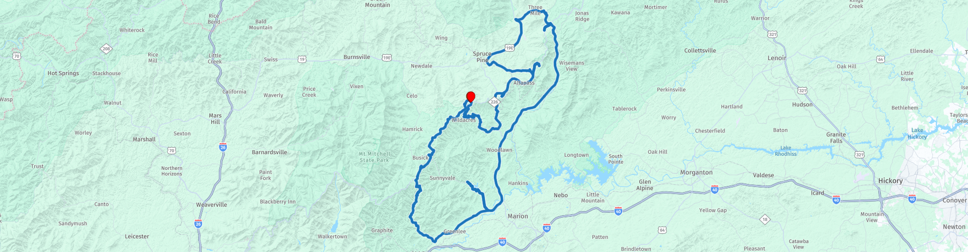
 This route is all about elevation changes and curves while being surrounded by trees and mountains.
The NC-226A takes you south out of Little Switzerland and for the next 10 miles your eyes will move from apex to apex as you lean from left to right, through curve after curve.
When reaching the junction with the 226 turn left and head back towards the Blue Ridge Parkway (BRP).
Pull over at Table Rock Overview (WP4) for some great view of Table Rock, this is just one of many opportunities to get the camera out on this journey. Further along the BRP you will see The Loops Overlook (WP5) on the right, from here you can see views down to the historic Orchard at Altapass, a farmer’s market-type store that was built by the railroad back in 1908. Next along the road is the North Cover Overlook (WP6) and Heffner Gap Overlook (WP7). Bear Den overlook is next (WP8) and then North Toe River Valley overlook is the final viewpoint along this part of the BRP.
Soon you pass over the Linville Falls Highway and it is this road that will the next on our journey. This road is a much faster road as it does not have the speed restrictions of the Blue Ridge Parkway and the easy long curves allow you to sit back and enjoy the road for a while.
The Linville Caverns is along this road (WP11) and a chance to look under the mountains instead of over
At the intersection with US 70 W turn right and continue along the last part of easy riding.
Take a right onto State Highway 80 and pause for a coffee at Dos Mundos Two Worlds Coffee Shop (WP14) and get ready for the Devil’s Whip.
When a road has it’s own Facebook page then it must be something special. 2000 feet in elevation change. 160 curves in 12 miles. Everyone has heard of the Tail of the Dragon but that is pretty flat unlike the last 3 miles of the Devil’s Whip!
As you start the road is an easy ride, but as the waters of the Lake Tahoma (WP16) appear on the right it is time to concentrate as the curves begin. And they are all types of bend from long sweeping curves to hairpin switch backs. And as you near the Blue Ridge Parkway the rise in elevation is felt as you turn through hairpin after hairpin.
As you turn right onto the Blue Ridge Parkway things slow down, the speed limits are much lower and why would you want to miss the views along the way. Overlook viewing points are all along the road with space to pull over and take some great pictures. 10 Miles along the parkway it is a right turn back into Little Switzerland and another deserved coffee break.


 Links
Links  Usage
Usage Want to download this route?
You can download the route for free without MyRoute-app account. To do so, open the route and click 'save as'. Want to edit this route?
No problem, start by opening the route. Follow the tutorial and create your personal MyRoute-app account. After registration, your trial starts automatically.  Disclaimer
Use of this GPS route is at your own expense and risk. The route has been carefully composed and checked by a MyRoute-app accredited RouteXpert for use on TomTom, Garmin and MyRoute-app Navigation.
Changes may nevertheless have occurred due to changed circumstances, road diversions or seasonal closures. We therefore recommend checking each route before use.
Preferably use the route track in your navigation system. More information about the use of MyRoute-app can be found on the website under 'Community' or 'Academy'.