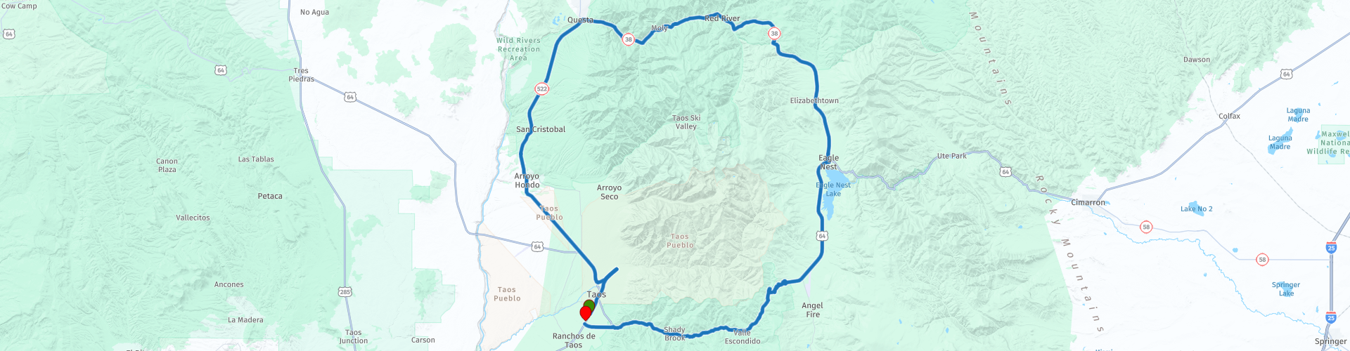
Enchanted Circle Scenic Byway from Taos New Mexico

This route was brought to you by:
RouteXpert Paul Hedges - Adv RouteXpert
Last edit: 06-01-2021
 Route Summary
 Enjoy this 4 star ride
 Share this route


Animation

Verdict


Duration
3h 30m

Mode of travel
Car or motorcycle

Distance
144.23 km

Countries

 RouteXpert Review
 On one section of the road you are passing ranch style houses right out of any early cowboy film. Make your way around the next bend and you are faced with a log cabin and half expect Julie Andrews to announce that 'the hills are alive' It really is as though someone has picked up a part of The Alps and moved them to New Mexico.
It links the oldest continuously occupied residence in New Mexico, Taos Pueblo, the United States' first memorial to Vietnam War veterans, and stunning scenery recognizable from such films as “Butch Cassidy and the Sundance Kid” and “Easy Rider”.
Taos Pueblo is an ancient pueblo belonging to a Taos-speaking Native American tribe of Puebloan people that have populate the area for over 1000 years.(WP5)
It might also look familiar as it was used as a backdrop for Dennis Hopper's Easy Rider. Dennis lived in nearby Taos for many years and that is also his final resting place.
Head North to Questa and more history abounds, the area has shown evidence of habitation from as early as 5000 BC. So stop grab a coffee and take in the local artisan crafts that are all around.
Heading East to Red River and you are presented with more sweeping views of the Alpine scenery while the roads offer long easy, undulating bends to travel along.
Heading down from Bobcat Pass(WP16) at nearly 10000 feet above sea level South you pass Elizabethtown. Elizabethtown was the first incorporated town in New Mexico in 1866 that sprang up around the gold and copper mines. All that is left now is a few ruins.
Arriving in Eagle Nest it is time for a break, a town of mixed history. For many years it was just a crossroads for the Native American people. Then the Eagle Nest Dam was built, and the town appeared on the side of the new lake. The in the 1920s when illegal gambling became popular. Almost overnight, Eagle Nest became a party town full of slot machines, saloons, drinking, and dancing. In the 1940s, the town was busted for illegal gambling. While most slot machines were destroyed with axes, it’s rumoured some were thrown in the lake by owners trying to avoid arrest, and local legend says that you can see them at the bottom of the lake when the water is low.
Travel over the high 9,101 foot Palo Flechado Pass and down into the Canyon of the Rio Fernando de Taos. There are picnic areas, campsites, and many trails through the canyon. Taos Canyon is home to many artist studios that are open to visitors much of the summer and fall season. As you begin the descend the mountain into the valley the canyon provides a spectacular view of the sage-covered mesa and the distant San Juan at the southern end of Taos. Each bend offers a different view and there are plenty of bends to enjoy as you head West back to Taos.
History, scenery as well as great riding. If this isn’t a great way to turn spare time into memories and smiles, I don’t know what is. A great 4 star day


 Links
Links  Usage
Usage Want to download this route?
You can download the route for free without MyRoute-app account. To do so, open the route and click 'save as'. Want to edit this route?
No problem, start by opening the route. Follow the tutorial and create your personal MyRoute-app account. After registration, your trial starts automatically.  Disclaimer
Use of this GPS route is at your own expense and risk. The route has been carefully composed and checked by a MyRoute-app accredited RouteXpert for use on TomTom, Garmin and MyRoute-app Navigation.
Changes may nevertheless have occurred due to changed circumstances, road diversions or seasonal closures. We therefore recommend checking each route before use.
Preferably use the route track in your navigation system. More information about the use of MyRoute-app can be found on the website under 'Community' or 'Academy'.