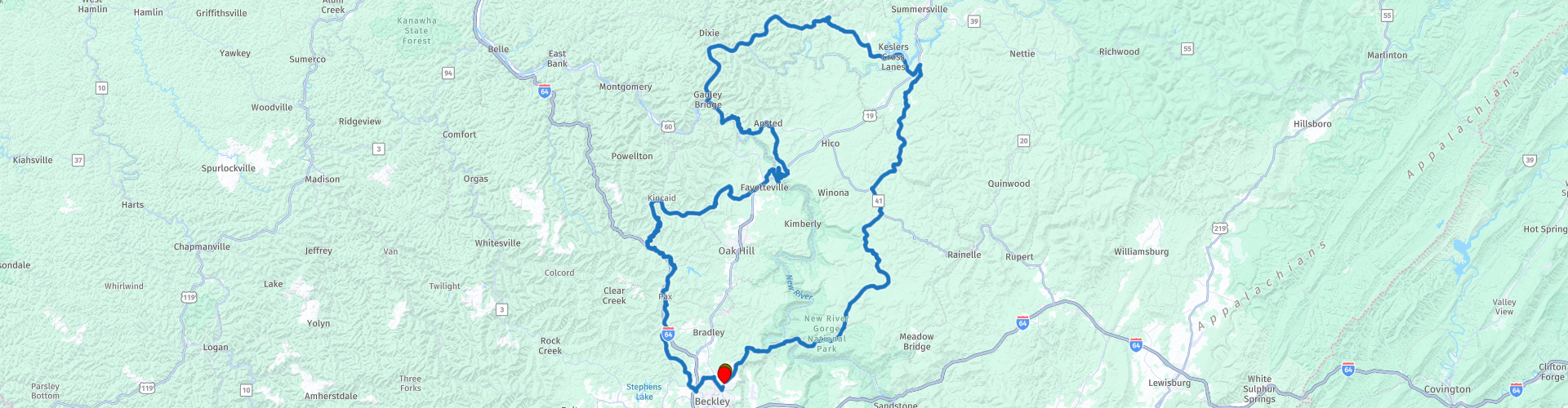
Round tour from Beckley through New River National Park

Questo percorso è stato creato da:
RouteXpert Nick Carthew - (MRA Master)
Ultima modifica: 14-12-2022
 Riepilogo percorso
  Condividi questo percorso


Animation

Verdetto


Durata
7h 6m

Modalità di viaggio
Auto o moto

Distanza
234.40 km

Paesi

 Revisione RouteXpert
 Entro 15 minuti dall'inizio, attraverserai il New River che ha dato il nome al New River Gorge National Park and Preserve. Ironia della sorte, il New River è considerato da alcuni geologi uno dei fiumi più antichi del mondo e sicuramente uno dei fiumi più antichi del Nord America!
Attraversare il New River ti porta nella contea di Fayette e immediatamente sulla tua destra vedrai un cartello storico della contea di Fayette, che rivendica la valle del Mississippi (spartiacque) per la Gran Bretagna. Il 1 settembre 1671, Thomas Batts, Thomas Wood e Robert Fallam partirono da Petersburg, in Virginia, con le guide della Prima Nazione per esplorare oltre le montagne. I coloni che si erano stabiliti sulla costa orientale sapevano molto poco di ciò che c'era oltre i monti Appalachi. Si sperava di poter scoprire una rotta commerciale attraverso il continente.
Il percorso lascia presto il New River sulla strada provinciale 41 o Stanaford Road, passa la stazione ferroviaria di Prince e segue Laurel Creek e poi Chestnut Knob Fork lungo una strada alberata della valle, con occasionali scorci dei torrenti e la linea ferroviaria ora ridondante che utilizzava per servire l'industria del carbone per cui questa zona è famosa.
6,5 miglia dopo la Prince Station, puoi fermarti in un piccolo punto di sosta sul lato della strada per vedere e fotografare Hemlock Hollow Falls. Non aspettarti di vedere le cascate del Niagara, ma il facile accesso e la breve distanza dal ciglio della strada lo rendono una tappa obbligata. Sebbene di piccola statura, l'ambientazione boschiva di queste cascate è molto piacevole alla vista.
L'ex villaggio minerario di Layland è il prossimo.
Laurel Creek e Layland in particolare sono state fortemente estratte per il carbone, la fonte di energia che ha guidato la rivoluzione industriale, tutto, dai transatlantici, alle ferriere e al combustibile per riscaldare le case, richiedeva più carbone.
L'estrazione mineraria iniziò a Layland alla fine del 1800, diverse miniere di carbone sfruttarono il giacimento di carbone di Fire Creek che aveva uno spessore medio di 4 piedi lungo Laurel Creek, e nel 1919 si diceva che nove miniere operassero lungo Laurel Creek. La maggior parte di queste miniere è stata estratta negli anni '50, ma il carbone è stato estratto a Layland fino agli anni '80. Ma è per il tragico disastro minerario che Layland sarà sempre ricordato:
La New River & Pocahontas Consolidated Coal Company possedeva e gestiva una serie di miniere a Layland, nella contea di Fayette. La mattina del 2 marzo 1915, una massiccia esplosione colpì la miniera n. 3 di Layland. L'esplosione ha ucciso 112 uomini all'interno della miniera. L'esplosione è stata così potente che un fattorino di generi alimentari che camminava nelle vicinanze è stato ucciso fuori dalla miniera. Poco dopo l'esplosione, i primi 7 sopravvissuti sono usciti dalla miniera. Ciò ha dato speranza alla folla che circondava la miniera, che è stata rapidamente persa poiché nei giorni successivi sono stati recuperati diversi corpi.
Uno dei maggiori pericoli per i soccorritori erano i gas mortali, chiamati after-damp, che riempivano la miniera dopo l'esplosione. Infatti, molti dei corpi recuperati dalla miniera sono risultati morti per soffocamento, non per l'impatto dell'esplosione. Due gruppi di uomini all'interno della miniera si sono barricati dall'umidità e sono sopravvissuti per tre giorni fino a quando il ventilatore della miniera non è stato acceso, consentendo agli uomini di fuggire con aria pulita.
Il 6 marzo, il primo gruppo di cinque uomini è uscito dalla miniera. Uscendo hanno trovato un biglietto di un gruppo di 41 uomini che si erano barricati anch'essi nella miniera, e presto i soccorritori hanno aiutato il secondo gruppo a uscire. Questi uomini sono sopravvissuti masticando i lacci delle scarpe e mangiando la corteccia dei puntelli della miniera. Molti dei sopravvissuti, temendo il peggio, avevano scritto note di morte ai loro cari durante il periodo in cui erano rimasti intrappolati. La loro sopravvivenza ha sorpreso la comunità di Layland, che aveva preparato bare e scavato tombe per i sopravvissuti, aspettandosi che gli uomini venissero trovati morti.
L'esplosione è risultata essere il risultato dell'accensione del metano diffuso dalla polvere di carbone. La polemica circonda il disastro. Quando il segretario degli interni ha voluto riconoscere gli sforzi dei soccorritori federali, molti nella comunità hanno sostenuto che non sono stati i soccorritori ma l'ingegnosità dei minatori sopravvissuti a salvarli. Il carbone ha continuato ad essere estratto a Layland fino agli anni '80. La chiusura delle miniere e la rimozione della ferrovia fecero diminuire la prosperità di Layland.
Nel 2014 è stato eretto un memoriale in ricordo dei minatori che hanno perso la vita nell'esplosione della miniera di Layland e in riconoscimento dei 53 uomini sopravvissuti al disastro. Il memoriale è stato finanziato in parte dalla National Coal Heritage Area Authority e attraverso i fondi raccolti dalla comunità di Layland. Gli organizzatori del memoriale hanno affermato che l'incidente della miniera di Layland era stato dimenticato. Questo memoriale ora ricorda la storia a volte dimenticata e tragica dell'estrazione del carbone del West Virginia.
Sulla destra si possono vedere i vecchi edifici in pietra dell'ex centrale elettrica della miniera e sulla sinistra alcune case abbandonate della compagnia carboniera. Il memoriale si trova accanto alla chiesa di Layland.
A poco meno di 10 miglia da Layland e hai l'opportunità di girare a sinistra per visitare Glade Creek Grist Mill.
L'hai visto raffigurato su calendari, tazze e libri da tavolino. È il Glade Creek Grist Mill, una delle immagini più fotografate al mondo. Situato su un ruscello di montagna disseminato di massi al Babcock State Park, il mulino battuto dalle intemperie offre uno scenario pittoresco per tutte e quattro le stagioni per foto di matrimoni e altri scatti memorabili delle vacanze. Costruito nel 1976 è una replica di un mulino originale del 1800.
All'incrocio tra la strada provinciale 41 e la US60, puoi vedere un cartello storico che indica:
"La vicina autostrada fa parte del percorso che attraversa W.Va. da Lewisburg a Point Pleasant commemorato dallo stato per commemorare la marcia dell'esercito coloniale americano di 1.200 uomini guidati da Andrew e Charles Lewis. Dopo un mese di marcia questo esercito sconfisse uno Shawnee Forza indiana guidata da Cornstalk nella battaglia di Point Pleasant sulle rive dei fiumi Ohio e Kanawha, 10 ottobre 1774."
Lascerai la US60 dopo un paio di miglia e ti ricongiungerai alla strada provinciale 41, anche se ora è conosciuta come The Wilderness Highway. Questa è un'ottima strada da percorrere, soprattutto quando raggiungi Meadow River poiché la strada segue i contorni del fiume offrendo alcune lunghe curve. Attraversando il fiume Meadow a Nallen esci dalla contea di Fayette e nella contea di Nicholas, quando raggiungi il Monte Nebo puoi fermarti per un caffè all'Appalachian Coffee House.
Accanto a vedere è un po' una follia, il Summersville Lake Lighthouse.
Di solito i fari sono riservati per aiutare le barche a navigare in acque pericolose, evitare le barriere coralline o trovare ingressi ai porti. Ma, anche senza accesso all'oceano, il West Virginia ospita un faro. Il faro è alto 104 piedi con un'altezza massima di 2,164 piedi sopra il livello del mare. I visitatori che salgono i 122 gradini del ponte della galleria vengono premiati con una magnifica vista a 360 gradi del lago Summersville e della Gauley Ridge National Recreation Area.
L'idea del faro nasce nel 2009 da uno scherzo e da una felice coincidenza. I proprietari del Summersville Lake Retreat stavano chiacchierando con un ospite che lavorava con una squadra che costruiva torri eoliche nelle vicinanze. Se voleva deviare una delle sezioni della torre verso la ritirata, i proprietari della ritirata scherzavano; l'avrebbero tenuto e camuffato da faro. È successo così che il parco eolico avesse una torre della turbina da risparmiare. Era rotolato giù da un camion e aveva subito dei danni che lo rendevano inadatto alla produzione eolica, ma poteva essere riutilizzato per altri usi. Incoraggiati da questo colpo di fortuna, i proprietari progettarono di acquistare la turbina eolica e organizzarne la consegna, mantenne la parola data e la trasformò in un faro. Il pezzo della corona, un faro rotante Westinghouse vintage che proietta un raggio di luce che può essere visto da 30 miglia di distanza, è stato donato da Rader Airfield e restaurato da un maestro elettricista locale.
Un po 'più avanti e puoi fermarti al punto panoramico della diga di Summersville.
La costruzione della diga di Summersville iniziò nel 1960 come mezzo per controllare le inondazioni nella Kanawha Valley del West Virginia. A 390 piedi di altezza e 2.280 piedi di lunghezza, la diga di Summersville è la seconda diga più grande del suo genere negli Stati Uniti. È una tale impresa ingegneristica che Lyndon B. Johnson, il vicepresidente degli Stati Uniti al momento dell'apertura della diga, fosse presente alla cerimonia del taglio del nastro nel 1966 e dedicò ufficialmente la diga.
Il lago è il lago più grande del West Virginia, con 2.700 acri (1.100 ettari) di acqua e oltre 60 miglia (97 km) di costa al livello dell'acqua della piscina estiva. La sua profondità massima è di 327 piedi.
Da Summersville Lake il percorso si dirige a ovest verso la catena montuosa Allegheny, spesso indicata come il luogo di nascita dei fiumi.
Ti unirai al fiume Gauley e seguirai il suo percorso tortuoso per 10 miglia fino al ponte Gauley dove si unisce al New River e poi diventano il fiume Kanawha. Il Kanawha scorre per circa 97 miglia prima di unirsi al fiume Ohio che alla fine sfocia nel possente Mississippi.
Da Gauley Bridge, svolta a sinistra sul Midland Trail o US60, una National Scenic Byway e un paio di miglia a monte del New River e puoi fermarti per una foto di Cathedral Falls, una delle cascate più alte del West Virginia. Qui, il Cane Creek scende di circa 60 piedi su una sporgenza rocciosa di arenaria e scisto. C'è un piccolo parcheggio sulla sinistra con un breve sentiero facile che porta alla base delle cascate.
Un altro posto dove fermarsi è la bizzarra attrazione conosciuta come: Mystery Hole.
Il Mystery Hole è una serie di stanze sotterranee in cui le pareti e i pavimenti sono costruiti ad angolo per dare l'impressione che ci sia qualcosa che non va nella gravità nell'area. C'è una sezione in cui l'acqua scorre apparentemente verso l'alto e la guida turistica siede sulla sedia con due gambe che fluttuano nell'aria e altre due gambe sostenute dal muro.
Hawk's Nest Overlook è un altro posto da non perdere. Il belvedere offre una vista a volo d'uccello dell'aspro Parco Nazionale e Riserva del New River Gorge sottostante.
Un progetto idroelettrico nelle vicinanze divenne noto come l'incidente di Hawk's Nest. Durante la costruzione di un tunnel lungo tre miglia da parte della Union Carbide a partire dal 1927, il tunnel è stato riempito di polvere di silice. Ai lavoratori non sono state fornite maschere per proteggersi, anche se la direzione le indossava durante i brevi periodi di visita per l'ispezione. Di conseguenza, migliaia di lavoratori, per lo più poveri e afroamericani, morirono di silicosi, a volte anche in un solo anno.
La diga per il progetto idroelettrico può essere vista dal belvedere a circa 178 m sopra il New River.
Lascerai il Midland Trail ad Ansted e ti dirigerai verso il New River Gorge Bridge, ma invece di attraversare il ponte, questo percorso ti porterà sotto di esso per ammirare l'ingegneria.
Al momento della costruzione, l'arco del New River Gorge Bridge lo ha reso il ponte ad arco in acciaio più lungo del mondo, titolo che ha mantenuto fino al 2003 con la costruzione del Lupu Bridge in Cina a Shanghai. Completato nell'ottobre 1977, una sfida di viaggio è stata risolta. Il ponte ha ridotto a meno di un minuto un viaggio di 40 minuti lungo strette strade di montagna e attraverso uno dei fiumi più antichi del Nord America. Quando si tratta di costruzione di strade, le montagne possono rappresentare una sfida. Nel caso del New River Gorge Bridge, la sfida si è trasformata in un'opera d'arte strutturale: la campata in acciaio più lunga dell'emisfero occidentale e la terza più alta degli Stati Uniti.
Passerai sotto il ponte due volte mentre scendi verso il fiume, ma la vista migliore di tutte è dal vecchio ponte Tunney Hunsaker. Questo storico ponte a travatura reticolare in ferro con copertura in legno prende il nome dal pugile americano ed ex capo della polizia di Fayetteville. La costruzione del ponte fu completata nel 1889 e la giustapposizione tra vecchio e relativamente nuovo mostra il grande progresso dell'ingegneria in soli 90 anni.
Lasciando il fiume e risalendo la tortuosa strada per Fayetteville, puoi girare a sinistra per attraversare il New River Gorge Bridge, quindi voltarti e tornare indietro, un viaggio di meno di dieci minuti e ne vale la pena.
Fayetteville ha recentemente guadagnato il secondo posto nella lista delle 15 migliori cittadine da visitare in America dello Smithsonian Magazine. Non è la prima volta che Fayetteville attira l'attenzione nazionale. La piccola città più cool. La migliore città fluviale. Questi sono tutti titoli che Fayetteville ha guadagnato (e meritato!) nell'ultimo decennio. Per questi motivi ho suggerito di fare una sosta pranzo qui.
Dopo pranzo puoi scegliere di tornare a Beckley attraverso la US19, un viaggio di circa 30 minuti o rimanere con il percorso e tornare in un paese minerario usando strade molto tortuose e tornare a Beckley dopo circa 1 ora e 30 minuti.
Il percorso tortuoso utilizza alcune piccole strade alberate che è una gioia percorrere, in particolare la sezione molto tortuosa dopo aver attraversato Loop Creek e dirigersi verso Paint Creek.
Paint Creek è un affluente del fiume Kanawha e fa anche parte dello spartiacque del Mississippi. Scorre per 42 miglia e seguirai il suo corso serpeggiante e controcorrente per 14 miglia, attraversandolo più volte mentre torni a Beckley.
Divertiti


 Collegamenti
  Utilizzo
 Vuoi scaricare questo percorso?
Puoi scaricare il percorso gratuitamente senza un account MyRoute-app. Per farlo, apri il percorso e fai clic su 'Salva con nome'. Vuoi modificare questa rotta?
Nessun problema, inizia aprendo il percorso. Segui il tutorial e crea il tuo account MyRoute-app personale. Dopo la registrazione, la tua prova inizia automaticamente.  Disclaimer
L'utilizzo di questo percorso GPS è a tue spese e rischio. Il percorso è stato accuratamente composto e controllato da un RouteXpert accreditato dall'app MyRoute per l'utilizzo su TomTom, Garmin e navigazione dell'app MyRoute.
Ciononostante potrebbero essersi verificati cambiamenti a causa di mutate circostanze, deviazioni stradali o chiusure stagionali. Si consiglia pertanto di controllare ciascun percorso prima dell'uso.
Utilizzare preferibilmente la tracklog del percorso nel sistema di navigazione. Maggiori informazioni sul l'uso dell'app MyRoute può essere trovato sul sito Web in 'Community' o 'Academy'.

Virginia Occidentale
Informazioni su questa regione
La Virginia Occidentale (West Virginia in inglese) è uno Stato federato degli Stati Uniti d'America, situato nella regione degli Appalachi, negli Stati Uniti d'America orientali. Confina con la Virginia a sud-est, con il Kentucky a sud-ovest, con l'Ohio a nord-ovest, con la Pennsylvania a nord e con il Maryland a nord-est. La Virginia Occidentale è il 41º stato per superficie e il 38° più popoloso tra i 50 stati. La capitale e maggiore città è Charleston.
Divenne uno stato a seguito della Convenzione di Wheeling, in cui 50 contee nord-occidentali della Virginia i cui proprietari terrieri possedevano pochi o nessuno schiavo, decisero di separarsi dalla Virginia durante la guerra di secessione statunitense. Il nuovo stato fu ammesso all'Unione il 20 giugno 1863 e divenne un importante stato cuscinetto fra Unione e Confederazione. La Virginia Occidentale è stato l'unico stato a costituirsi separandosi da uno degli Stati Confederati e uno dei due stati formatisi durante la guerra di secessione (l'altro è il Nevada, separatosi dal Territorio dello Utah).
Il Census Bureau e l'Associazione dei Geografi Statunitensi classificano la Virginia Occidentale come parte del Sud; il panhandle settentrionale si estende presso Pennsylvania e Ohio, con le città di Wheeling e Weirton, appena oltre il confine dell'area metropolitana di Pittsburgh, mentre Bluefield è a meno di 110 km dalla Carolina del Nord. Huntington, nel sud-ovest, è vicina agli stati di Ohio e Kentucky, mentre Martinsburg e Harper's Ferry, nel panhandle orientale, sono considerati parte dell'area metropolitana di Washington, tra gli stati di Maryland e Virginia. La particolare posizione della Virginia Occidentale la rende inclusa in diverse regioni geografiche, tra cui il Medio Atlantico, l'Alto Sud e il Sud-Est. È l'unico stato che è interamente all'interno dell'area servita dalla Commissione Regionale degli Appalachi, la zona comunemente definita "Appalachia".Lo stato è conosciuto per le sue montagne, per le sue industrie di legname e di estrazione del carbone, molto importanti a livello storico, oltre che per la sua politica e storia del lavoro. È una delle aree del mondo più dense per quanto riguarda il carsismo, il che la rende area privilegiata per le ricerche scientifiche e per le escursioni; le terre carsiche contribuiscono molto alla presenza di trote di acqua dolce. La Virginia Occidentale è anche molto conosciuta per una vasta gamma di opportunità ricreative, tra cui lo sci, il rafting, la pesca, la caccia, il mountain biking e l'escursionismo.
Leggi di più su Wikipedia
Divenne uno stato a seguito della Convenzione di Wheeling, in cui 50 contee nord-occidentali della Virginia i cui proprietari terrieri possedevano pochi o nessuno schiavo, decisero di separarsi dalla Virginia durante la guerra di secessione statunitense. Il nuovo stato fu ammesso all'Unione il 20 giugno 1863 e divenne un importante stato cuscinetto fra Unione e Confederazione. La Virginia Occidentale è stato l'unico stato a costituirsi separandosi da uno degli Stati Confederati e uno dei due stati formatisi durante la guerra di secessione (l'altro è il Nevada, separatosi dal Territorio dello Utah).
Il Census Bureau e l'Associazione dei Geografi Statunitensi classificano la Virginia Occidentale come parte del Sud; il panhandle settentrionale si estende presso Pennsylvania e Ohio, con le città di Wheeling e Weirton, appena oltre il confine dell'area metropolitana di Pittsburgh, mentre Bluefield è a meno di 110 km dalla Carolina del Nord. Huntington, nel sud-ovest, è vicina agli stati di Ohio e Kentucky, mentre Martinsburg e Harper's Ferry, nel panhandle orientale, sono considerati parte dell'area metropolitana di Washington, tra gli stati di Maryland e Virginia. La particolare posizione della Virginia Occidentale la rende inclusa in diverse regioni geografiche, tra cui il Medio Atlantico, l'Alto Sud e il Sud-Est. È l'unico stato che è interamente all'interno dell'area servita dalla Commissione Regionale degli Appalachi, la zona comunemente definita "Appalachia".Lo stato è conosciuto per le sue montagne, per le sue industrie di legname e di estrazione del carbone, molto importanti a livello storico, oltre che per la sua politica e storia del lavoro. È una delle aree del mondo più dense per quanto riguarda il carsismo, il che la rende area privilegiata per le ricerche scientifiche e per le escursioni; le terre carsiche contribuiscono molto alla presenza di trote di acqua dolce. La Virginia Occidentale è anche molto conosciuta per una vasta gamma di opportunità ricreative, tra cui lo sci, il rafting, la pesca, la caccia, il mountain biking e l'escursionismo.
Visualizza regione
 Statistiche
  8
8Quantità di recensioni RX (Virginia Occidentale)
 1441
1441Quantità di visitatori (Virginia Occidentale)
 44
44Quantità di download (Virginia Occidentale)
 Indirizza le collezioni in questa regione
 Il viaggio su strada definitivo negli Stati Uniti, parte 05
Michel van Hagen mi ha sfidato a seguire il Roadtrip del Dr. Randy Olsen come base per creare l'Ultimate USA Road Trip per l'app MyRoute RouteXpert Library. Ho raccolto questa sfida e ho iniziato a febbraio 2022.
Lo scienziato Dott. Randy Olsen, divenuto noto per aver utilizzato la sua conoscenza degli algoritmi per trovare "Waldo" nella famosa serie di libri americani "Where's Waldo", è stato sfidato da Tracy Staedter, di Discovery News, a utilizzare lo stesso algoritmo per creare il perfetto Road Trip creando gli Stati Uniti, che visiterà quasi tutti gli stati degli Stati Uniti. Alaska e Hawaii non sono incluse in questo Road Trip a causa della loro posizione geografica.
Alla base del percorso c'erano i seguenti tre requisiti: in tutti i 48 paesi deve esserci almeno una sosta in punti famosi, monumenti, siti storici, parchi nazionali, ecc. Ho aggiunto ulteriori punti interessanti, bellissimi tour e percorsi.
Dopo più di 26 mesi, il lavoro è terminato e, con il grande supporto di Nick Carthew, ho creato 129 rotte che attraversano 48 stati degli Stati Uniti e parte del Canada. Questa è la quinta raccolta che ti porta da Cocao Beach in dieci giorni attraverso la Florida, la Georgia, la Carolina del Sud e la Virginia fino a Kill Devil Hills nella Carolina del Nord.
Visualizza raccolta percorsi