R13 QLD Cairns to Georgetown

This route was brought to you by:
RouteXpert Hans van de Ven (Mr.MRA)
Last edit: 11-01-2021
 Route Summary
 Australia is very large; 8 million km2, which is more than 226 times larger than the Netherlands! Has a diversity of flora and fauna; the most diverse types of plants, trees and animals, especially birds and a lot of typical Australian marsupials, which you will not find anywhere else in the world!
Enjoy all the beauty immensely: From the evergreen tropical rainforests, to the vast Outback; from the desert to the countless and peaceful idyllic palm beaches; from the winter sports areas in the southeast to the vibrant and impressive metropolis of Melbourne, Sydney and Perth.
You will see it all and experience it in this amazing tour through Australia, a tour to remember!
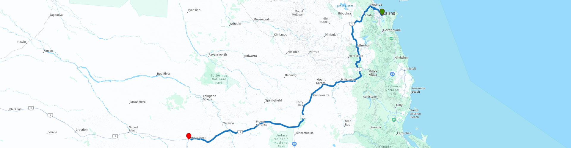
Starting point: Cairns, Novotel
End Point: Georgetown, Latara Motel
The route has been created for TomTom, Garmin and MyRoute-app Navigation users.
ATTENTION: DRIVE LEFT!
 Share this route


Animation

Verdict


Duration
4h 52m

Mode of travel
Car or motorcycle

Distance
409.67 km

Countries

 RouteXpert Review
 Georgetown is located 1,885 km northwest of Brisbane, 384 km southwest of Cairns and 298 km east of Normanton. It is located 299 m above sea level. The settlement that originally appeared was called Etheridge but changed to Georgetown in 1871. It is named after the assistant gold commissioner in Gilberton, a man named Howard St George.
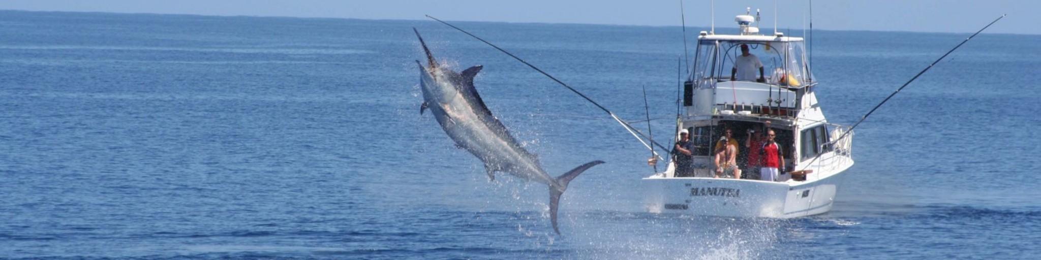
After you may have hooked a black marlin or visited the Great Barrier Reef, it is now time to drive to the next place. You head north to the Barron Gorge National Park, which is part of the Wet Tropics of Queensland World Heritage Area. The national park's name refers to the Barron River, which forms its way through the eastern plateau of the Atherton Tableland. There are some waterfalls in the park, such as Stony Creek Falls and Barron Falls. The park is covered in tropical rainforest, and tropical Queensland forests are considered the oldest continuously surviving tropical rainforest in the world with the highest concentration of primitive flowering plants. The black park, kemiri nut and stripe ferns grow in the national park. The fauna includes several species unique to tropical Queensland, such as the muskrat kangaroo and Lumholtz tree kangaroo, or found only in this region in Australia, such as the banded marsupial squirrel and helmet cassowary. Other species in the national park include the platypus, marsupial martens, flying foxes, damsel pigeons, great-legged chickens, the sea crocodile and the blue imperial page. The Kuranda Scenic Railway, an old railway line, and the Kuranda Skyrail, a funicular that connects the coast to the village of Kuranda in the hill country, pass through the park.
Once you have passed through the park, you can stop for an ice cream along the way and visit the war museum in Mareeba. In Atherton, this city located about 1370 km northwest of Brisbane, it is time for coffee with some goodies. For this you can stop at Love - Lee Cooking Wholefoods Cafe.
The next stop is at De crater & De Dinner Falls, the crater is located at an altitude of about 355 meters above sea level. The Dinner Falls is a mix of three waterfalls with dive, segmented and cascade features on the Upper Barron River in the Far North region of Queensland. Next, a stop at The Millstream Falls, a cascading dive waterfall on The Millstream, located in the UNESCO World Heritage Wet Tropics in the far north of Queensland. The falls consist of two sets of falls, Big Millstream Falls and Little Millstream Falls, both located on the same watercourse about 500 feet apart.
After about 190 KM it's time to fill up and get something to eat and / or drink, you can do this at the Norwest Gate Roadhouse. The next refueling option is 125 KM away. After 260 Km, exit the Kennedy Highway and turn into Gulf Developmental Road. During this last 160 KM, you will pass through Mount Surprise, where you can refuel and cross some more rivers including the Einasleigh River, it starts at an altitude of 809 m and ends at a height of 79.4 m where it passes in the Gilbert River. The Einasleigh River descends about 730 m over a length of 618 km. You can refuel just in front of the motel, so that you can start the next route with a full tank.
This 4-star rated route mainly involves beautiful through roads. You pass through nature reserves and some nice places, where you can stop for a snack or to refuel.
General info:
Queensland (literally translated: Queensland) is a state in northeastern Australia. Queensland is the second largest in area and Australia's third largest state in terms of population. The state was named after Queen Victoria, the monarch at the time of the settlement of the former colony. The capital and largest city of Queensland is Brisbane, located in the southeast of the state. The northern portion of the state, separated by the Tropic of Capricorn, is tropical. The south is subtropical. Queensland was originally a British crown colony that emerged in 1859 after secession from New South Wales. The city of Brisbane originally started out as the Moreton Bay penal colony, which held convicts who again committed errors while serving their sentences in New South Wales.
Brisbane is located about 100 kilometers north of the border between Queensland and New South Wales. Southeast Queensland also has two larger population centers: the Gold Coast south of Brisbane, and the Sunshine Coast north of Brisbane. Along the approx. 2000 km long coast (from south to north) are the following cities: Coolangatta - Gold Coast - Brisbane - Sunshine Coast - Gympie - Maryborough - Hervey Bay - Bundaberg - Gladstone - Rockhampton - Mackay - Townsville - Cairns. The following cities are inland (counterclockwise): Warwick - Toowoomba - Roma - Charters Towers - Mount Isa. The world's largest city by surface, Mount Isa is located in northwestern Queensland. The surface of the city is 42,904 km² (about the surface of the Netherlands!), But the city has a population of approximately 20,000 (2003).
The state is home to five World Heritage Sites: Australian Mammal Fossil Sites (Riversleigh / Naracoorte),
Gondwana rainforests, Fraser Island, The Great Barrier Reef and the Tropical wetlands of Queensland.
Queensland can be roughly divided into three parts:
1.The eastern coastal strip, dominated by the Great Australian Separation Mountains. From north to south there are also the Darling Downs, the Bunya Mountains, the Carnarvon Gorge, the Whitsunday Islands, Hinchinbrook Island and the Atherton Tableland. Off the coast, north of Fraser Island, the Great Barrier Reef begins.
2.The tropical Cape York Peninsula in the north. To the north of this is the Straits Torres with the Straits Torres Islands and to the east most of the Great Barrier Reef.
3 Most of the dry interior, called the Queensland outback, with the Channel Country in the southwest.


 Links
Links  Usage
Usage Want to download this route?
You can download the route for free without MyRoute-app account. To do so, open the route and click 'save as'. Want to edit this route?
No problem, start by opening the route. Follow the tutorial and create your personal MyRoute-app account. After registration, your trial starts automatically.  Disclaimer
Use of this GPS route is at your own expense and risk. The route has been carefully composed and checked by a MyRoute-app accredited RouteXpert for use on TomTom, Garmin and MyRoute-app Navigation.
Changes may nevertheless have occurred due to changed circumstances, road diversions or seasonal closures. We therefore recommend checking each route before use.
Preferably use the route track in your navigation system. More information about the use of MyRoute-app can be found on the website under 'Community' or 'Academy'.