Fortified Cities from Saint Omer

This route was brought to you by:
RouteXpert Jan Koelstra (jan cabrio)
Last edit: 11-03-2025
 Route Summary
 On the other side of the border, fortresses in the Southern Netherlands were less important due to the continued presence of numerous Spanish troops in the garrison towns.
The route has been awarded five stars because of the variety between the vastness of the landscape, historic villages and towns on the one hand and the ingenious constructions of the fortified towns and forts on the other.
 Share this route


Animation

Verdict


Duration
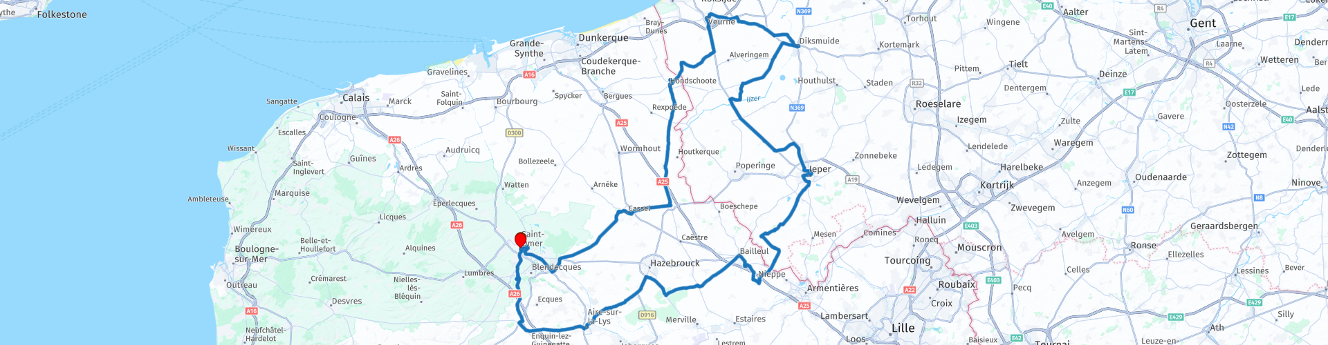
10h 13m

Mode of travel
Car or motorcycle

Distance
218.34 km

Countries


 RouteXpert Review
 This tour starts and ends in Saint-Omer and visits part of West Flanders.
The fortified city of Saint-Omer is not so well known to tourists but has a lot to offer. When exploring the centre of Saint-Omer you will notice that there are both Flemish and French influences in the architectural styles. One of the major attractions is the Cathedral of Our Lady, which was built from the 12th to the 15th century. It is not only the largest church in the area but also has one of the greatest art treasures, such as a painting by Rubens.
In the middle of the centre there is also a 20 hectare city park that, thanks to its slopes, allows you to enjoy beautiful panoramas. Also very special is the Sandelin museum that has three beautiful collections and is housed in a beautiful mansion. And then there is the ruin of the St-Bertin Abbey where the history of Saint-Omer began.
After refueling, you will arrive in the industrial city of Arques, known for a number of remarkable factories and industries. The largest glass and crystal factory in the world, a ship lift that is unique in France, a railway line that is unparalleled and a gigantic brewery: welcome to the city of industrial records.
It took 7 years to build the Fontinettes boat lift, put into service in 1888. This system, the only one of its kind in France, replaced a ladder of 5 locks on the Neuffossé canal. The barges were able to overcome a height difference of 13 metres using only the force of the water. The glass and crystal factory, founded in 1825, will soon celebrate its bicentenary and has left its mark on the national and worldwide industry. Glassblowing, automation, mechanised crystal production, new types of glass, Arc has never stopped innovating.
Your next stop is Cassel. It is not known exactly when the city's defensive walls were built. What is certain is that Cassel was under fire for decades during the 17th century. The city then changed occupiers a few times and eventually became part of France at the end of the 17th century. In 1677, the Dutch lost a very important battle here.
In the area of Cassel there were once 18 mills of which the city mill is the only remaining witness. Originally it was used to beat oil, now only for grinding grain.
You drive past Steenvoorde, where the iconoclasm began. On 10 August 1566, the Protestant preacher Sebastiaan Matte gave a stirring sermon in the fields near Steenvoorde. Among other things, he condemned the worship of Catholic images. Twenty followers then entered the Sint-Laurentiusklooster, destroyed all the statues of saints and took many things with them. Today, there is no trace left of the monastery itself, located a few kilometres from Steenvoorde. In the Sint-Pieterskerk in Steenvoorde, you can still see a bell from the Laurentiusklooster. This 17th-century, now fully restored, building can boast a breathtaking 92-metre-high tower with niches for saints.
Hondschoote, which is a little further away, became known for its textile industry. In 1557, a cloth hall, now the town hall, was opened. Between two windows, several cartouches have been placed, with the coats of arms of city administrators. Inside the town hall, the old courtroom is certainly worth a visit. A panel tells the history of the city.
Here is also what is probably the oldest mill in Western Europe. The Noordmeule, type post mill, is said to date from the 12th century. On one of its beams the year 1127 can be read.
After passing the French-Belgian border, the fortress of Veurne approaches. Here, coffee is a welcome guest.
The town hall was built in the late 16th century, early 17th century (the date 1628 is on the facade), in Flemish Renaissance style. The Grote Markt was also thoroughly renovated at the same time. Adjacent to the town hall is the Landshuis, the former courthouse. Visitors are particularly fascinated by the beautiful mantelpiece in the Stenen Zaal and the decoration of the former courtroom. Above the Landshuis rises the late Gothic belfry tower (Unesco World Heritage), five 'storeys' high.
The construction of the current St. Walburga Church began at the end of the 13th century. There was already a church on this site, probably built in the 9th century. The work on the church tower began somewhat later than the rest of the church, in the 14th century, but was never completed. Lack of financial resources is of all times. The interior is truly beautiful. It includes a very beautiful Flemish Renaissance choir stall from 1596 and various works of art from the period of the 16th to the 18th century. The church feels like a cathedral because of its height, beautiful stained glass windows and magnificent choir. Definitely worth a visit!
On the site where the Sint-Niklaaskerk now stands, there was already a church in the 12th century, at a time when the harbour of Veurne still reached here. The original church was rebuilt at the end of the 15th century. The oldest work of art in the church is a three-part altarpiece from 1534 by Jacob van Amstel. In 1644, the famous Penitential Procession of Veurne originated from this church, which still passes through the streets every year on the last Sunday in July.
The First World War has a lasting impact on Diksmuide. This is reflected in the well-known sites and cemeteries. An impressive introduction is a visit to the Dodengang trench.
Enjoy a unique panoramic view of the city from the roof terrace of the IJzertoren. The Belfry is located next to the town hall and is on the list of 56 belfries in Belgium and France that are recognized as world heritage by UNESCO.
You then drive to Lo, an old fortified town with the Westpoort as the only remaining of the 4 city gates of Lo and even one of the few, still existing city gates and defense towers in West Flanders. The canals, the course of which can still be clearly followed, served as reinforcement and demarcation of the city limits. We know that the city only had a diameter of approx. 400 m. Here too, the old city hall and belfry are a historical and protected monument. It is now used as a hotel and restaurant.
Then Ypres is the next city you visit. It is a beautiful destination for those who love history and cozy cities. The city is not that big, but has a very cozy center full of terraces and nice restaurants. Here you can eat a meal.
During the First World War, the front was near Ypres for many years and heavy fighting took place here. In old photographs you can see the bizarre images of Ypres, which was completely in ruins in 1918. Here and there a few walls were still standing but almost everything was destroyed. Eventually it was decided to rebuild Ypres, and the British were given the Menin Gate as a monument. You still come across a great many British people in Ypres. School classes, groups of bus passengers, but also divisions of Scottish Highlanders... they all visit Ypres as a tribute. Nowadays you can still find countless reminders of this period in and around Ypres.
You now move through the Heuvelland region, via Kemmel, the festival town of Dranouter and Nieuwkerke to the border. At Steenwerck you enter France again. Here is a beautiful church in Romanesque-Byzantine style.
Bailleul (Belle) could easily be a town in Flanders, but it is actually located in the north of France, more specifically in the region Coeur de Flandre (Heart of Flanders). The facades of houses and monumental buildings look Flemish because of their architecture. Every quarter of an hour, the carillon of the belfry plays beautiful tunes with a Flemish touch. It may all seem authentic today, but almost everything was restored or rebuilt after attacks by both the Germans and the Allies. In this way, the city was given a Flemish 'look'. Inspiration was found in buildings from Bruges and Ypres.
The belfry is one of the most popular monuments in the historic town of Aire-sur-la-Lys. Built between 1716 and 1724, with the approval of Louis XIV, it towers 58 metres above the town. It is connected to the town hall, which was also built during the same period. On the corner of the large square of Ariën, you will find this historical landmark: the Bailliage (Bailiff's House). This building was already in use in 1600. Today, it houses the tourist office.
At first glance, it is a village like Thérouanne, like you would find in a dozen. But appearances can be deceiving, because Thérouanne can boast an impressive past as a prosperous fortified city where emperors and kings fought. Much of that glorious past is still hidden under the green fields around the current village. So there is still a lot to discover in what some enthusiastic historians sometimes call the Pompeii of the North. In 1553, the city was completely destroyed by order of Emperor Charles V, after the French king declared war on him. Nothing remains of the numerous buildings, including the cathedral. At the time of the destruction, the city had about 2000 inhabitants. Afterwards, the place was abandoned. Over the centuries, Thérouanne has had various names: Tervanna, Terwaan, Terenburg.
You have now almost reached the end of this tour. On the way to Saint-Omer you will pass La Coupoule. During the Second World War there was a launching platform for V2s here. Now converted into a multimedia museum. You will learn more about the flying bombs but also the connection with space travel. The history of the development of the bombs, their use during the battle, the suffering caused and how they played a part in space travel. All nicely packaged in films, photos, models, information boards and so on.
After the possible visit, it goes to Saint-Omer. Your end point is again at the parking lot at the cathedral. Now find a nice spot for a terrace.


 Links
Links  Usage
Usage Want to download this route?
You can download the route for free without MyRoute-app account. To do so, open the route and click 'save as'. Want to edit this route?
No problem, start by opening the route. Follow the tutorial and create your personal MyRoute-app account. After registration, your trial starts automatically.  Disclaimer
Use of this GPS route is at your own expense and risk. The route has been carefully composed and checked by a MyRoute-app accredited RouteXpert for use on TomTom, Garmin and MyRoute-app Navigation.
Changes may nevertheless have occurred due to changed circumstances, road diversions or seasonal closures. We therefore recommend checking each route before use.
Preferably use the route track in your navigation system. More information about the use of MyRoute-app can be found on the website under 'Community' or 'Academy'.

Hauts de France
About this region
Hauts-de-France (French pronunciation: [o də fʁɑ̃s] (listen); Picard: Heuts-d'Franche; lit. 'Heights of France') is the northernmost region of France, created by the territorial reform of French regions in 2014, from a merger of Nord-Pas-de-Calais and Picardy. Its prefecture is Lille. The new region came into existence on 1 January 2016, after regional elections in December 2015. The Conseil d'État approved Hauts-de-France as the name of the region on 28 September 2016, effective the following 30 September.With 6,009,976 inhabitants (as of 1 January 2015) and a population density of 189 inhabitants/km2, it is the third most populous region in France and the second most densely populated in metropolitan France after its southern neighbour Île-de-France. It is bordered by Belgium to the north.
Read more on Wikipedia
View region
 Statistics
  38
38Amount of RX reviews (Hauts de France)
 30456
30456Amount of visitors (Hauts de France)
 2513
2513Amount of downloads (Hauts de France)
 Route Collections in this region
 24 Magnificent trails in France
It is clear that France is one of the most beautiful and best touring countries. It offers an incredibly varied landscape with good roads and a pleasant climate. It is not for nothing that you see so many motorcyclists there. My previous collection of 25 routes in France (25 Magnificent routes in France) were based on the route descriptions from the Motortourgids France part 1 made by Bert Loorbach.
This collection of 24 routes comes from Motortourgids France part 2. In this collection, a difference has been made between approach routes and motorcycle tours in a certain area. The approach routes can also be used in combination with the routes from Motortourgids France part 1
The routes are sometimes slightly adjusted based on the tips that Bert Loorbach gives in his description, or because of another place to spend the night, or to reach the minimum length of 2 hours for the MRA Library. For each route, the review contains a more detailed description, including options to stay overnight or places of interest along the way, which are also indicated with a POI and if possible with a short description.
Two or more routes have been created for a number of areas, such as for Burgundy, Auvergne, The Alps, Tarn and Cévennes and Nord-Pas de Calais. These routes can be nicely combined in a multi-day trip.
View Route Collection
The 10 most downloaded routes in France from RouteXpert Catherine De Groote
Hello and welcome to this collection of the Top 10 MyRoute app downloaded routes in France.
A great new event will be announced soon, where all of these routes can be driven.
Download them all now and place them in a new "Top 10" folder so that you always have them at hand.
If you are going to drive one of these routes in the meantime, track them with the MRA Mobile App or with MRA Navigation. Take some photos (moments) along the way as they will come in handy.
Create a travelogue of your Top 10 driven routes and add the recorded track to it.
There will also be some great prizes on offer, so keep an eye on the MRA-RouteXperts page and your email.
View Route Collection