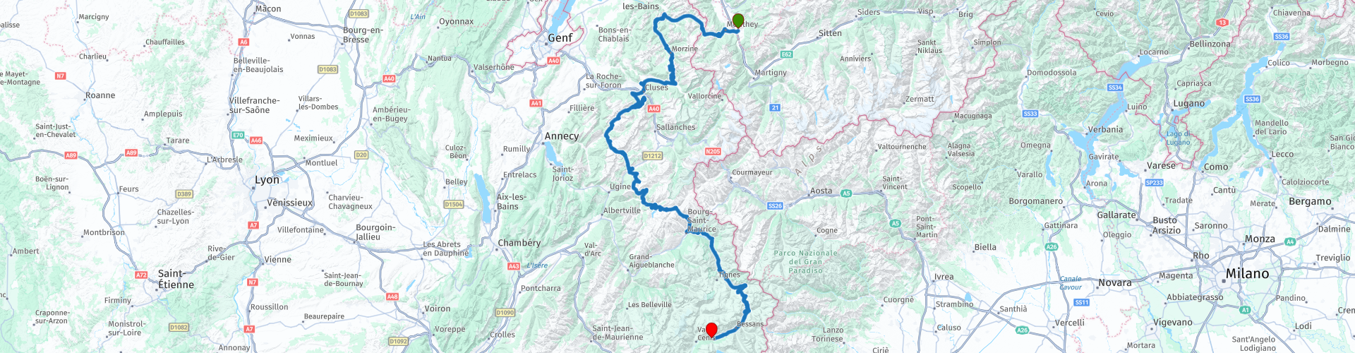
Bex Lanslebourg Rhonedal Mont Cenis

This route was brought to you by:
RouteXpert Hans van de Ven (Mr.MRA)
Last edit: 11-02-2023
 Route Summary
 Start: Bex
Finish: Lanslebourg
The route made the same for TomTom, Garmin and MyRoute-app Navigation users.
If you want to ride this TT, keep the info below in mind:
- Average mountain experience
- TT from A to B
Source: Promoter 07, September / October 2018.
 Share this route


Animation

Verdict


Duration
7h 33m

Mode of travel
Car or motorcycle

Distance
330.52 km

Countries


 RouteXpert Review
 Col du Corbier (1235 m), Col du Ranfolly (1250 m), Col de Joux Plane (1700), Col de la Colombiére (1618 m), Col des Aravis (1498 m), Col des Saisies (1438 m), Cormet de Roselend (1938 m), Col de l'Isera (2270 m).
This 5-star route is one of the 24 most beautiful Alpine routes in recent years!
Colored route points:
rp 9 - Coffee stop at Lhottys
rp 15 - Lunch stop at Restaurant Le Jalouvre
rp 19 - Coffee stop at Le Mont-Blanc
rp 28 - Coffee stop at Restaurant La Bouida
rp -34 - Tank stop at Avia
Route details:
-Winter closing: Col de l'Iseran and Cormet de Roselend from the beginning of October to the end of May. The other passes and roads are closed briefly depending on the weather.
-Alternative routes: South side of the Col du Petit St. Bernard (2188 m).
Ideal months: June to October. Chance of closing the high passes in September.
- Driving pleasure: Constantly, but Cormet de Roselend and the south side of the Col de l'Iseran stand out.
-Landscape: Cormet de Roselend and Col de l´Iseran. The view of Val d'Isère from the north side of l'Iseran is beautiful. At the start of the tour, the Col de Joux Plane offers an impressive view of the north-western flank of the 4810 m high Mont Blanc massif.


 Links
Links  Usage
Usage Want to download this route?
You can download the route for free without MyRoute-app account. To do so, open the route and click 'save as'. Want to edit this route?
No problem, start by opening the route. Follow the tutorial and create your personal MyRoute-app account. After registration, your trial starts automatically.  Disclaimer
Use of this GPS route is at your own expense and risk. The route has been carefully composed and checked by a MyRoute-app accredited RouteXpert for use on TomTom, Garmin and MyRoute-app Navigation.
Changes may nevertheless have occurred due to changed circumstances, road diversions or seasonal closures. We therefore recommend checking each route before use.
Preferably use the route track in your navigation system. More information about the use of MyRoute-app can be found on the website under 'Community' or 'Academy'.