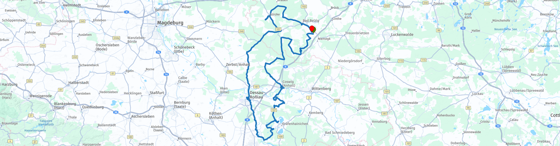
Roundtrip from Dahnsdorf through Flaming

Cet itinéraire a été créé par:
RouteXpert Catherine De Groote RouteXpert
Dernière modification: 15-04-2021
 Résumé de l'itinéraire
 Culturellement intéressants sont un certain nombre de villes historiques, de vieux villages, de châteaux et d'églises médiévales en pierre. Mais il y a aussi de larges plaines marécageuses, des zones viticoles fertiles et des paysages fluviaux en pente douce.
Le nom Fläming vient des immigrants flamands venus dans cette région alors slave aux XIIe et XIIIe siècles. Il y a des influences flamandes dans le dialecte local. La ville thermale de Bad Belzig est la porte d'entrée du parc naturel.
Le trajet obtient 5 étoiles. Cet itinéraire à moto vous emmène à travers le parc naturel de Fläming. C'est une région peu peuplée où il fait bon conduire sur de bonnes routes. Le paysage, les belles avenues et les nombreuses zones boisées de Fläming vous invitent à des balades à moto tranquilles. En termes de culture, cette balade est également intéressante: Coswig, Wörlitz, Dessau ont beaucoup à offrir. Le trajet vous emmène également à travers la région de l'ancienne mine de charbon brun.
 Partager cet itinéraire


Animation

Verdict


Durée
9h 7m

Mode de déplacement
Voiture ou moto

Distance
230.82 km

Pays

 RouteXpert Review
 Vous partez à la station-service Hoyer à Dahnsdorf. Ici, vous pouvez facilement vous rencontrer et il y a aussi la possibilité d'acheter quelque chose dans la boutique. Le paysage ici est ouvert et légèrement vallonné.
La route mène au château de Rabenstein à travers le paysage ouvert et légèrement vallonné. Le château domine le village de Raben, au sommet de la colline «Steiler Hagen». Construit au milieu du XIIe siècle comme point de vue sur la route, le château de Rabenstein a longtemps été considéré comme imprenable en raison de son emplacement au sommet de la pente raide et de ses solides défenses. La cave du château pouvait stocker de grandes réserves. Le côté le plus accessible à l'arrière de la colline était défendu par l'immense donjon et la guérite. La tour de granit, haute d'une trentaine de mètres, est la partie la plus haute du château. En plus d'escalader le donjon pour une vue fantastique sur Hoher Fläming, une visite guidée du château comprend également une visite de la salle des chevaliers, de la salle de torture, de la cave en fer, du puits, de la grange au toit de planches, de la chapelle Rosemarie et l'ancienne boulangerie de 1860.
La route se poursuit à travers les forêts de hêtres et de chênes sessiles jusqu'à Burg Hundeluft. Le château est situé à un croisement sur le Rossel. Il est en grande partie entouré d'eau et de marais. Cela a fourni une protection naturelle. Le château est sur une petite élévation, à environ 1,5 m au-dessus des environs. Il est divisé en un noyau et un bailey externe. Le château principal a un plan pentagonal irrégulier et une superficie d'environ 800 m². Trois bâtiments résidentiels et agricoles se dressaient contre le mur d'enceinte du château intérieur. À côté de ces bâtiments, il y avait une tour ronde dans le coin nord-ouest. Il avait un diamètre de 5 mètres.
A Coswig, situé sur la rive droite de l'Elbe, il y a un château mentionné dès 1187 à son emplacement actuel. On ne sait pas si une colonie slave existait avant cette époque. Appelée oppidum en 1215, Coswig était l'une des villes les plus importantes au nord de l'Elbe.
Malgré ses origines médiévales, le château Schloss Coswig est un exemple classique de l'architecture de la Renaissance et du baroque français. De la fin du 19ème siècle à la fin de la 2ème guerre mondiale, le château a été utilisé comme prison. Pendant cette période, le château abritait trois fois plus de prisonniers que prévu et beaucoup étaient utilisés pour le travail forcé. Les travaux de restauration ont commencé en 1958, après quoi le bâtiment a été utilisé pour les archives nationales et nationales de 1961 jusqu'à la réunification allemande en 1989. Les Archives fédérales ont ensuite continué à utiliser le bâtiment jusqu'en 1998. Le bâtiment a été vacant de 1998 à 2006. L'intention était alors d'utiliser le palais comme centre de coopération et d'échange transnationaux dans le domaine de la culture. Les étages de la prison ont été démolis en 2008 et l'aile sud est revenue à son état historique. Des concerts ont lieu dans le bâtiment depuis 2014.
Juste à l'extérieur de la ville, vous trouverez le cimetière d'honneur soviétique Coswig. C'est un cimetière pour les travailleurs forcés soviétiques, y compris les victimes d'une explosion à l'usine d'armes `` Westfälisch-Anhaltische Sprengstoff AG '' (WASAG) le 14 novembre 1944 et un mémorial pour les soldats soviétiques tombés au combat. Selon les données allemandes, 78 morts ont été enterrés, selon les données russes 92 prisonniers de guerre soviétiques, travailleurs forcés et soldats de l'Armée rouge morts au combat.
Vous traversez l'Elbe avec le ferry Wörlitz-Coswig. Le ferry traverse une distance de 125 mètres et prend environ 5 minutes. Techniquement, le ferry est un ferry de réaction, propulsé par le courant de l'eau. Le ferry est attaché à un câble flottant fermement ancré dans le lit de la rivière en amont du ferry. Pour faire fonctionner le ferry, il est placé à un angle dans le ruisseau, ce qui fait que la force du courant fait balancer le ferry à travers la rivière sur le câble.
Le château de Wörlitz est considéré comme l'édifice du classicisme allemand et est l'un des rares bâtiments allemands du palladianisme. Le château de Wörlitz, tout comme le parc Wörlitz associé, fait partie du patrimoine mondial de l'UNESCO. Le pavillon de chasse baroque a été démoli pour la construction du château. Le constructeur était Friedrich Wilhelm von Erdmannsdorff. Le palais a été construit pour le prince et son épouse la princesse Luise de Brandebourg-Schwedt et était destiné à représenter la dynastie. La construction a été achevée en 1773. Il est considéré comme l'édifice du classicisme allemand. Les bâtiments anciens et anglais et l'architecture d'Andrea Palladio ont servi de modèles.
Le château d'Oranienbaum a été conçu au XVIIe siècle à l'initiative d'Henriëtte Catharina van Oranje-Nassau, par son compatriote constructeur Cornelis Ryckewaert.
Oranienbaum est un exemple impressionnant du baroque hollandais en Allemagne: la ville, le château et le parc sont géométriquement alignés. Le parc captive avec sa grande collection de plantes d'agrumes qui se trouvent dans la plus grande orangerie d'Europe en hiver. On pense que le jardin anglo-chinois est le seul survivant du genre en Allemagne. Le château et le parc d'Oranienbaum font partie du site classé au patrimoine mondial de l'UNESCO de Gartenreich Dessau-Wörlitz. Le château peut être visité pour un droit d'entrée de 8,5 euros par personne. Le parc du château est librement accessible, la pagode restaurée et le salon de thé sont accessibles après inscription.
Sur la place du marché, vous pouvez bien manger au Cafe Restaurant am Markt. Dans le menu, vous trouverez des plats sélectionnés pour les petits et les grands affamés, préparés avec des produits frais locaux.
Vous traversez l'Oranienbaumer Heide jusqu'à Judenberg. Ici, vous conduisez directement au Gremminer See.
Le hameau de Zschiesewitsch se trouvait ici, mais il a maintenant été englouti par des fouilles pour l'extraction de lignite. Le Gremminer See ou Ferropolissee est un lac qui a émergé de l'ancienne mine à ciel ouvert de Golpa-Nord. C'est le huitième plus grand lac et en même temps l'un des lacs les plus au nord du district central des lacs allemands. Le nom est dérivé du lieu de fouille Gremmin. Le Gremminer See est situé au nord de la ville de Graefenhainichen, dans la zone moraine terminale du plateau de Graefenhainichen-Schmiedeberg, également connu sous le nom de Dübener Heide.
Cinq énormes excavateurs et gerbeurs de lignite - dont certains sont désormais accessibles - ont échappé à la démolition et aujourd'hui, comme les géants de l'acier à Ferropolis sur le lac Gremmin, ils inaugurent une ère industrielle révolue.
Ferropolis, la ville du fer, n'est pas seulement un musée à ciel ouvert, mais aussi un lieu événementiel impressionnant avec son arène sur une péninsule sur le lac. Ferropolis fait partie de la Route européenne du patrimoine industriel (ERIH), un musée vivant chargé d'histoire impressionnante. Le mélange de musique, d'orages de lumière et d'expérience de la nature à l'ombre des colosses de fer fait de la visite de l'arène unique une expérience inoubliable.
Le pont Gremminer sur le balcon de la ville offre une belle vue panoramique sur le Gremminer See et Ferropolis.
Vous revenez sur une courte distance à Jüdenberg où vous tournez à gauche vers Mölhau. Cet endroit est fortement caractérisé par l'extraction de lignite. À Möhlau, il reste 3 mines à ciel ouvert, qui sont maintenant sous l'eau et utilisées comme lacs de baignade. Ces mines à ciel ouvert ont été construites pour alimenter la centrale électrique de Zschornewitz, qui se trouve à seulement quelques kilomètres. La centrale au charbon brun, autrefois la plus grande et la plus moderne au monde, a été construite en 1915 par les habitants du quartier de Zschornewitz, aux abords du Dübenheide. A proximité immédiate du site de l'usine, une colonie résidentielle vous invite à un voyage à l'époque de la construction sociale et de la vie au début du XXe siècle. A l'instar des cités-jardins anglaises, de nombreuses façades vertes et colorées caractérisent l'ensemble résidentiel. Pour l'Expo 2000, l'ensemble du complexe de colonies a été rénové avec amour et reconverti en un joyau de l'architecture moderne des colonies.
La Mulde est un affluent non navigable de l'Elbe et mesure 124 km de long (ou 290 km, si sa plus longue rivière de source est incluse). Il est connu comme le fleuve le plus rapide d'Europe centrale. Le Mulde surgit juste au nord de Colditz de la confluence de l'ouest de Zwickauer Mulde et de l'est de Freiberger Mulde, tous deux originaires des monts Métallifères. Le fleuve se jette dans l'Elbe au nord de la ville de Dessau.
Le parc de la ville de Dessau est un parc d'environ huit hectares à l'ouest du centre-ville historique.
Le château de Georgirum est une maison de campagne néoclassique construite pour le prince Johann Georg (1748–1811) par Friedrich Wilhelm von Erdmannsdorff, à partir de 1780. Il abrite la Anhalt Picture Gallery avec une riche collection de peintures allemandes et hollandaises de maîtres anciens. La vaste collection d'estampes et de dessins est exposée dans le "Fremdenhaus" (maison d'hôtes littérale) dans le Georgium. Le palais est entouré d'un vaste jardin anglais avec divers monuments, structures et sculptures romantiques telles que le "Fremdenhaus" susmentionné, la ruine romaine, le Monopteros (un temple rond dans l'ordre ionique), deux exemples d'arcs antiques et la statue du prince Franz en vêtements classiques. Il fait partie de l'empire de Dessau-Wörlitz, un site du patrimoine mondial de l'UNESCO, l'un des premiers et plus grands parcs anglais d'Allemagne et d'Europe continentale.
Le mausolée de Dessau est un ancien lieu de sépulture des ducs d'Anhalt dans le quartier Dessau-Roßlau de Ziebigk. Aujourd'hui, le zoo de Dessau est situé dans l'enceinte du parc du mausolée. Le mausolée a été construit au Georgium entre 1894 et 1898 dans le style de la Haute Renaissance comme une construction de dôme dorique sur ordre du duc Friedrich. Le plan d'étage du bâtiment central correspond à une croix grecque. La crypte a été calquée sur le style roman. Le bâtiment a une longueur totale de 46 m, une largeur totale de 38 m et une hauteur de 43 m. Le dôme a un diamètre de 14 M. L'intérieur est enduit de ciment de marbre.
Dessau devient le centre de l'architecture moderne au XXe siècle lorsque Walter Gropius s'y installe avec son Bauhaus. Ce centre «d'architecture et de design contemporains» a également survécu à la dernière période de la RDA. Après la chute du Mur, Dessau a également été relancé en revanche. Depuis le début des années 1990, le paysage industriel s'est transformé en un «royaume des jardins industriels» - un spectacle inconnu.
La visite se poursuit tranquillement vers le nord. Vous entrez dans un paysage varié avec de nombreuses belles vues dégagées sur un parcours légèrement vallonné. À Reuden / Anhalt, vous pouvez vous arrêter pour boire un verre au Tequila Drive Biker Café. Depuis sa création, Tequila Drive est devenu l'un des points de rendez-vous les plus populaires de «l'est» de la république.
Vous pouvez visiter le château Eisenhardt à Bad Busy. Le château, vieux de plus de mille ans, domine Bad Belzig. Le complexe du fort bien conservé abrite aujourd'hui une boutique de la ferme avec un café et un hôtel. Une visite au château vous emmène également au donjon de 28 mètres de haut, d'où vous avez une vue phénoménale sur Bad Belzig et le paysage environnant.
Via la réserve naturelle Verlorenwasserbach Oberlauf, vous arrivez à la fin de ce circuit qui mérite facilement une note de cinq étoiles en raison de son excellent revêtement routier et de ses nombreux aspects touristiques.


 Liens
Liens  Utilisation
 Vous voulez télécharger cette route?
Vous pouvez télécharger l'itinéraire gratuitement sans compte MyRoute-app. Pour ce faire, ouvrez l'itinéraire et cliquez sur 'enregistrer sous'. Vous voulez éditer cette route?
Pas de problème, commencez par ouvrir la route. Suivez le tutoriel et créez votre compte personnel MyRoute-app. Après l'enregistrement, votre essai démarre automatiquement.  Avertissement
L'utilisation de cet itinéraire GPS est à vos propres frais et risques. L'itinéraire a été soigneusement composé et vérifié par un RouteXpert accrédité par MyRoute-app pour une utilisation sur TomTom, Garmin et MyRoute-app Navigation.
Des modifications peuvent néanmoins s'être produites en raison de circonstances modifiées, de déviations de routes ou de fermetures saisonnières. Nous vous recommandons donc de vérifier chaque itinéraire avant de l'utiliser.
Utilisez de préférence le tracé de l'itinéraire dans votre système de navigation. Plus d'informations sur le l'utilisation de MyRoute-app peut être trouvée sur le site Web sous 'Communauté' ou 'Académie'