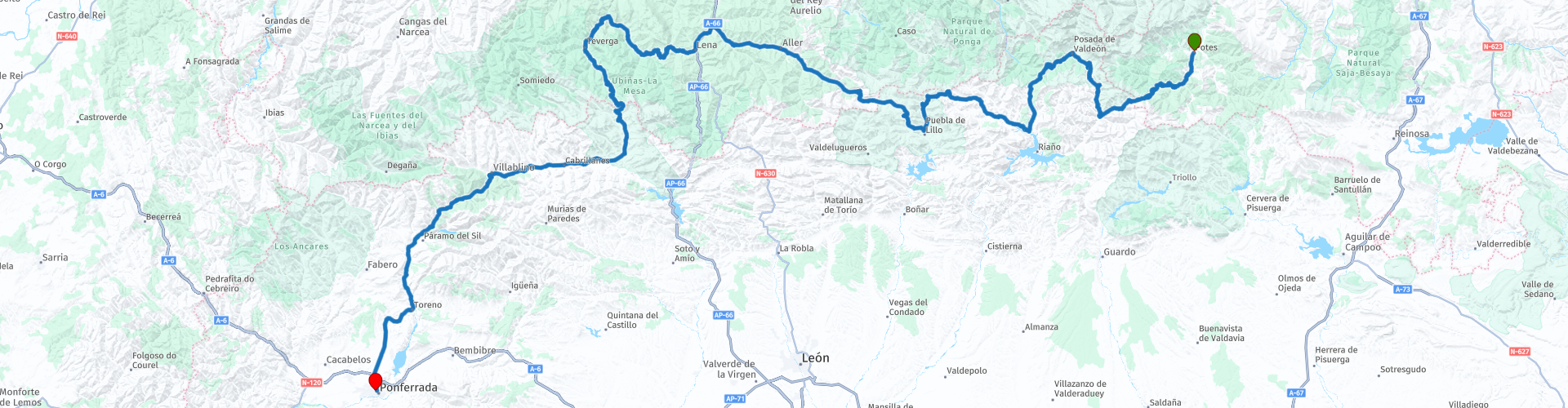
Potes to Ponferrada

This route was brought to you by:
RouteXpert Nick Carthew - (MRA Master)
Last edit: 10-04-2025
 Route Summary
  Share this route


Animation

Verdict


Duration
8h 10m

Mode of travel
Car or motorcycle

Distance
343.99 km

Countries

 RouteXpert Review
 Nestled in the mountains of León lies Portilla de la Reina, a dreamy village that seems like something out of a legend. Its houses nestled against the cliffs and its clean air make this place a paradise waiting to be discovered at an altitude of 1,243 m. The village is sheltered by four rocky outcrops: Cuervo, Cuesta, Cruz, and Cincho. The Yuso River runs through the centre of the village and it is the entrance area from León to the Picos de Europa National Park. The road surface is generally good and there are several hairpin bends to negotiate.
The high peaks of Torre del Hoyo de Liordes at 2477 metres, with the slightly shorter Torre de Salinas 2447 metres to the right are in front of you dominating the skyline.
I have suggested a coffee stop in the mountain village of Posada de Valdeón, noting better than sipping your coffee in fresh mountain air surrounded by mountain peaks at over 2000m.
There are viewpoint after viewpoint and you have to decide which ones to stop at, I have highlighted a few.
The Puerto de las Señales at 1625 metres above sea level is the highest point of this route. Las Señales is one of the highest mountain passes in the Cantabrian Mountains in an environment which has a great wealth of fauna and flora , as well as natural viewpoints of great scenic beauty. From its summit, you can also observe the natural surroundings of the Cantabrian Mountains.
Then you'll be passing through the ski resort of San Isidro which has the border between Castilla y Leon and the Principality of Asturias running right through the middle of it.
The route follows river valleys, with mountain peaks and meadows on a mixture of roads but all have a reasonable surface.
I have suggested a lunch stop in the mountain village of Bárzana, there are several places to choose from but you'd be hard pushed to better Casa Jamallo which offers delicious local cuisine at affordable prices.
After lunch the route uses the AS-228 and follows the Rio Teverga to a tunnel, when you emerge from the Túnel de Valdecerca after 498 metres, you'll be in the Las Ubiñas-La Mesa Natural Park. The great biological richness of Las Ubiñas - La Mesa Natural Park makes it one of the few places where you can still see the magnificent brown bear. There's thought to be only around 400 individuals roaming wild, but you're in the heart of bear country so keep a look out.
Once again, the views and scenery are spectacular and the roads have some good, fast sweeping bends and a good surface, making this route ideal for motorcycles.
As the valley tightens up, you can stop for fuel and then you will pass through the rugged Gorges de Paramo, a narrow gorge with sheer cliffs either side of you and a short rock tunnel too, another great motorcycle road.
There are viewpoints all along this section of the route and as the road is not busy, it is easy to stop to take pictures. Mirador de Ubiña gives a great view of Peña Ubiña at 2417 metres it is one of the highest peaks.
The route travels on the Puenta de Las Palomas or Pigeon Bridge that crosses over a deep ravine carved out by the River Sil. The route will follow the Sil for the next 72 kilometres all the way to the finish at Hotel Ponferrada Plaza.
Enjoy


 Links
Links  Usage
Usage Want to download this route?
You can download the route for free without MyRoute-app account. To do so, open the route and click 'save as'. Want to edit this route?
No problem, start by opening the route. Follow the tutorial and create your personal MyRoute-app account. After registration, your trial starts automatically.  Disclaimer
Use of this GPS route is at your own expense and risk. The route has been carefully composed and checked by a MyRoute-app accredited RouteXpert for use on TomTom, Garmin and MyRoute-app Navigation.
Changes may nevertheless have occurred due to changed circumstances, road diversions or seasonal closures. We therefore recommend checking each route before use.
Preferably use the route track in your navigation system. More information about the use of MyRoute-app can be found on the website under 'Community' or 'Academy'.