MTG2 12 Roundtrip French Alpes Veynes Devoluy Gap Veynes

This route was brought to you by:
RouteXpert René Plücken (MRA Master)
Last edit: 12-02-2021
 Route Summary
 climate. It is not for nothing that you see so many motorcyclists there. My previous series of routes in France were based on the route descriptions from the Motortourgids France part 1 made by Bert Loorbach.
This route comes from Motortourgids France part 2 and the original name is "The Alps Directions 1: Dévoluy".
In Motorbike guide France part 2 a difference has been made between approach routes and trips in a certain area. The approach routes can also be used in combination with the routes from Motortourgids France part 1
The routes are sometimes slightly adjusted based on the tips that Bert Loorbach gives in his description, or because of a different place to spend the night, or to achieve the minimum length of 2 hours for the MRA Library. For each route there is a more detailed description in the review, including options to stay overnight or places of interest en route, which are also indicated with a POI and if possible with a short description
The route is made suitable for Garmin, TomTom, Harley-Davidson BoomBox 2019 and Navigation App, can be downloaded for free and without My-Route-app registration. To do this, first click on the 'Use route' button and then on 'Save as'.
 Share this route


Animation

Verdict


Duration
3h 13m

Mode of travel
Car or motorcycle

Distance
173.66 km

Countries

 RouteXpert Review
 A nice trip to send a nice couple of hours from one Col to the other.
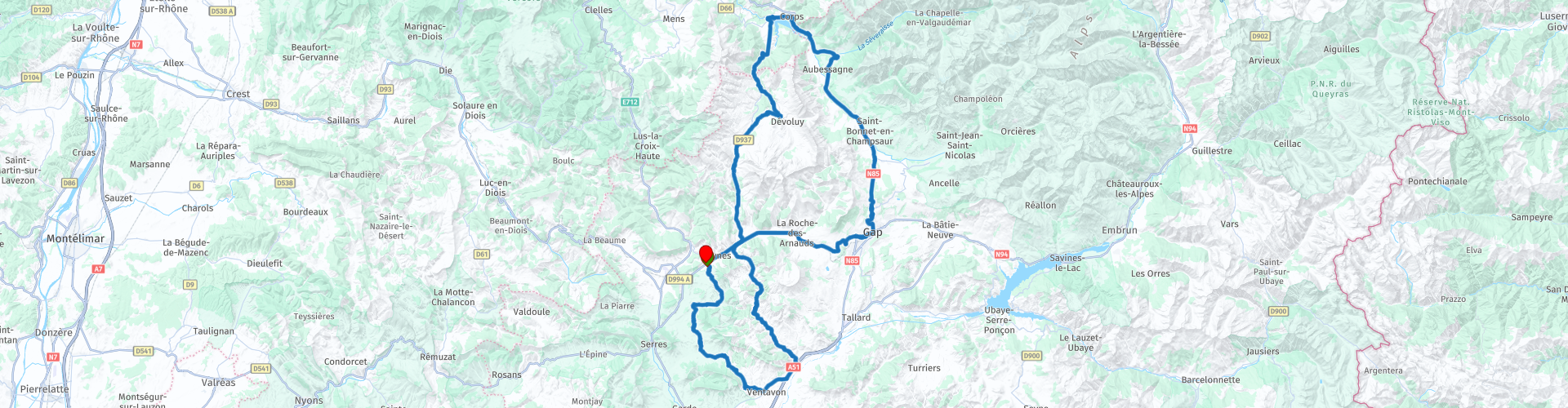
We leave from Camping Les Rives du Lac in Veynes to Gap to get a taste of the Alps. From Gap the original route has been supplemented with a wonderfully curvy part back to the campsite. The route has therefore been changed into a tour through the Dévoluy area.
Dévoluy is a small massif that actually belongs to the pre-Alps but already has peaks of more than 2500 meters. It is characterized by abandonment, this feeling is further enhanced if you drive through this area between twelve and two hours. Along the way real mountains, rugged rocks, lots of water and forest.
I also started a small tour south of Veynes because we want to drive through Dévoluy around noon with a lunch in the village of St. Disdier (RP9) at hotel restaurant “La Neyrette”. Here you can enjoy a good lunch on a terrace in the sun, with the mountains around you. If you order trout, you'll see the cook run outside a little later and catch one in the stream nearby. Grandiose.
Back to the route, we start at Camping Les Rives du Lac south of Veynes and we drive over a number of passes that are also used in Rally's such as Col de la Bachassette (RP2) and Col la Faye (RP3) which are even in the Rally the Monte Carlo has been used, this one is sure to be enjoyed. At Monêtier-Allemont take a short stretch of the D1085, after about 2.5 km we turn left, cross the canal and continue the drive on another beautiful winding D20 containing the Col d'Espréaux (RP6), which is also part of a rally course and the tour de France. On the D994 we turn left just before Montmaur and take the D937 with the simple Col du Festre through the rolling countryside, towards St. Disdier (RP11), where we stop for lunch.
After lunch we drive further north through tall pine trees towards Lac de Sautet, which is shining blue in the summer sun. You will pass the dam (RP12) and you will drive into Corps (RP13) a little later, a nice town with lots of cozy terraces so if you want to take a break you can. We are now driving on the famous N85 or the "Route Napoléon" (RP15). Napoléon used this route in the opposite direction when he returned from Elba in 1815 and headed north. This stretch of 40 kilometers is a wonderful ribbon of asphalt with the Col de Bayard (RP16) as a dessert and a steep descent to Gap (RP17), where the original end point of the route is described in the Motorbike Guide part 2. We take here the D994 back to the Camping.
A beautiful day with beautiful roads and beautiful nature, along the way not many details to stop for, but I still appreciate this route with 4 **** stars.


 Links
Links  Usage
Usage Want to download this route?
You can download the route for free without MyRoute-app account. To do so, open the route and click 'save as'. Want to edit this route?
No problem, start by opening the route. Follow the tutorial and create your personal MyRoute-app account. After registration, your trial starts automatically.  Disclaimer
Use of this GPS route is at your own expense and risk. The route has been carefully composed and checked by a MyRoute-app accredited RouteXpert for use on TomTom, Garmin and MyRoute-app Navigation.
Changes may nevertheless have occurred due to changed circumstances, road diversions or seasonal closures. We therefore recommend checking each route before use.
Preferably use the route track in your navigation system. More information about the use of MyRoute-app can be found on the website under 'Community' or 'Academy'.