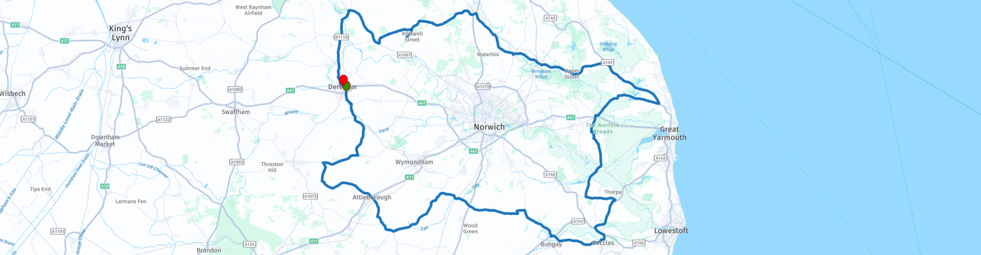
Round tour from Dereham Via Norfolk Broads

This route was brought to you by:
RouteXpert Paul Taylor
Last edit: 19-09-2023
 Route Summary
 You will get to enjoy the semi-natural habitat that has been created by the waterways with its living landscape and its vast open expanses of unspoilt wetland, rich in flora and fauna. Stooped rich in heritage, as it is now understood that the broads are man-made and was created purely by accident by the peat digging industry back in the 12th century .
There will be a chance to visit some of Norfolk’s old historic and repurposed train stations and to take a ride on a steam locomotive if you desire. Pass through the old Georgian town of Reepham, where you get to ride alongside part of the now disused twenty-six-mile-long Marriott’s way railway track.
This route in my opinion deserves 5***** stars because the roads are excellent, the scenery and attractions are both very good.
 Share this route


Animation

Verdict


Duration
6h 14m

Mode of travel
Car or motorcycle

Distance
205.17 km

Countries

 RouteXpert Review
 Sixteen miles on from here you will pass through the small market town of Attleborough, believed to be an Anglo-Saxon settlement, where in 1559 a great part of the town was destroyed by fire. Leaving Attleborough, you head out on the B1077 which offers some challenging but memorable roads. Your ride will take you around Bungay where you will go over the river Waveney; at this point you leave the county of Norfolk and head into Suffolk. A short distance away, you soon go around Beccles where you again cross back over the river Waveney and so, out of Suffolk and back into the county of Norfolk.
After leaving Beccles and just before reaching Reedham Ferry you pass the River Chet before it finally joins the River Yare a mile west of Reedham at Hardley Cross. This is a small river and only navigable for a total length of 3½ miles. From here it's up to Reedham Ferry to cross the River Yare. The current chain ferry is the only remaining vehicular ferry in Norfolk and saves users traveling time of over 30 miles. It was designed and built in 1984 at Oulton Broad by the late Fred Newson and current owner David Archer. The Archer family came to Reedham Ferry in early 1949 and can be proud that they are still there after 3 generations. The ferry can carry up to 3 cars at a time with a maximum weight of 12 tons. There has been a crossing at Reedham since the early 17th century. The original ferry was called "Norfolk Horse Ferries Under Stable" where horse-drawn vehicles were the main users of the ferry and it was still hand-wound across the River Yare in 1949, not becoming motorized until the early 1950s. The ferry runs continuously (on request) at a current price of £2 for motorcycles and runs from 6:30am to 10pm Monday to Friday and 8am on weekends.
Once across the other side of the River Yare you head towards Acle, where surprisingly records as far back as Saxon times, show that it was once a fishing port. From here you go through Fleggburgh before crossing the Filby Broads, the shallowest of all the broads at only 8ft (2.4m) deep and one of five broads that make up the Trinity Broads the others being Rollesby Broad, Ormesby Broad, and there are two much smaller broads Lily Broad and Ormesby Little Broad, the three largest broads of them all are Hickling, Barton and Oulton Broad. It was believed up until 60 years ago that all the broads were of natural occurrence because of their sheer scale and natural looking appearance, when in fact they are man-made waterways created by peat digging. The first written evidence of this dates to the 12th century when much of east Norfolk had been cleared of its woodland for fuel and building materials. For the next 200 years peat digging along with both Reed and sedge which was used for thatched roofs was harvested from the Broads fens and were part of a lively rural economy for centuries, both historic trades once employed hundreds.
Heading through the small villages of Filby whose name is derived from the Viking File the Dane, who settled in the area around 800 AD. After approximately 5.7 miles (9.2km) you will arrive at Ormesby Broads now a wetland, rich in wildlife, at 15ft (4.6m) deep and is one of the three largest Broads in this area the other 2 being Filby and Rollesby . In 1989 the Broads became a National Park and is Britain’s largest protected wetland and is a vital area for nature, the navigable waterways of the Broads National Park span for 125 miles, but they are actually located in the driest region of the UK, East Anglia.
Another popular feature that was often seen on the broads was the Norfolk Wherry , a unique type of sailing boat that was designed to navigate the shallow waters of the broads. The Wherry was designed with a distinctive 'gaff rig' of a single , high-peaked sail and the mast stepped well forward, they were used as cargo and passenger ships along the waterways as early as the 17th-century. There were three main types of wherries in operation, including trading wherries, pleasure wherries and more refined wherry yachts. By the 1940s, the use of trading wherries had fallen into decline as railways and roads stole their trade. Only eight of these historical boats still survive today. The Broads industry attracts more than seven million visitors a year for boating holidays, day pleasure cruise, walking, cycling , wildlife watching or other activities.
Leaving the Broads, you head towards Potter Heigham where you will cross the River Thurne Just 7 miles (11km) long, it passes under the medieval bridge that was built around 1385. From here it is a brisk ride towards Hoveton passing over another of the Norfolk Broads rivers the river Ant a tributary of the river Bure at 17 miles (27 km) long of which 8.75 miles are now navigable.
At Hoveton there is a route option to visit Wroxham Barns, Norfolk’s award-winning visitor attraction by turning left onto Tunstead Road and following for 1.4 miles. Wroxham Barns is set in the stunning countryside close to the Norfolk Broads, it houses some talented craftspeople who you can chat too whilst they work. Indulge in some retail therapy, browse their shops which offer everything from unique gifts and stylish clothes to fun toys and delicious foods, before taking a break for refreshment in our Courtyard Cafe or Farmyard Cafe who serve wholesome dishes and popular afternoon teas. There is free entry to the shops and café but a fee to visit the Farm and Fun Park, open every day from 10am to 5pm with free carparking.
Just after the turning for Wroxham Barns is the Bure Valley Railway, a 15in minimum gauge visitors' attraction in Norfolk. Created on the original disused full-gauge bed of a defunct passenger service to incorporate a new, adjacent pedestrian footpath. The railway runs from Wroxham to Aylsham and vice versa and is Norfolk's second longest heritage railway. You can take a trip back in time travelling by steam along the 9 miles of track, with three stops along the way, and 17 bridge crossings including the 105ft (32m) long girder bridge over the River Bure in Buxton with Lammas, and the Aylsham bypass tunnel under the A140. There is a Visitor centre for the Mid-Norfolk Railway in a former 1886 station building, with a tearoom and plenty of free onsite parking.
Taking a right out of Bure Valley railway you head towards Coltishall, caution there is now a speed restriction (40mph) enforced on this stretch of road until Coltishall. Once at Coltishall there is a scheduled stop for some refreshment and light lunch at Piece of Cake café, established originally in Hoveton in July 2010 and re-located in 2014 to what used to be the Old Salvation Army Hall, now known as the River Rooms. Everything that is sold, is fresh, locally sourced, and homemade, the cakes are very popular, as are the light lunches. You can choose a seat inside with views across the marshes or a seat in the outside walled courtyard. I can highly recommend this cafe the food is first class, the coffee is of exceptional quality (Lavazza) and the staff are very nice and friendly to, with ample free parking provided.
Shortly after leaving Piece of Cake Cafe, you go over the River Bure, where the bridge is now constructed of concrete and has gone through many incarnations over the years. The bridge was built in 1913, after the great flood of 1912 to allow the floodwaters to pass by.
Riding onto Alysham you have a route option, by turning right onto Norwich Road into Alysham and follow for 0.5 miles (0.8km) on the right you can visit the Aylsham end of the Bure Valley Railway, where there is a café and free parking available onsite. Leaving Alysham behind you, head out onto the B1149 to the Georgian town of Reepham, that was mentioned in the Domesday Book of 1086. Here it was listed as “Refham “ meaning the bailiff's or reeve's manor from the Old English gerafa (bailiff) and ham (homestead). Reepham has had market town status since 1277 and just 1 mile out of town is Whitwell and Reepham Station. Nestled in the mid-Norfolk countryside, just alongside Marriott’s Way that is now a 26-mile footpath, bridleway and cycle route that runs along the path of two disused railway lines a section of the old M&GN; line between Norwich City Station and Melton Constable (Norwich to Whitwell), and of the Great Eastern line between Wroxham and County School (Reepham to Aylsham) both joined by the Themelthorpe Curve. The route was named after the chief engineer and manager of the Midland and Great Northern Railway system William Marriott. The Station has been lovingly restored to its former glory. It Re-opened to the public in 2009, nearly 50 years after it was originally closed to passengers, with relayed track and sidings, acquired rolling stock brought the old station and signal box was brought back to life, you can now step back in time and explore the collection of steam engines, sit and have a bite to eat or drink or just enjoy a ride on the steam train, with loads of free onsite parking, but do check train timetables and opening times.
From Whitwell head for the A1067 to Guist where you will turn left onto the B1110 following the signs to Dereham for 2 miles (3.2km). There is a route option by turning left and travel for 0.2 miles (0.3km) to visit the County School Station; built in 1886 to serve the private school (for sons of local wealthy farmers or artisans). In 1904 the school became the Watt's Naval Training School this quaint station, once the junction for trains to Wells, Norwich, and Wroxham with three platforms an unusual stationmaster's house that was the former school gate house, sadly it was closed in 1964. Today it serves as a place of quiet reflection waiting patiently for the trains to return, you can explore the permissive footpaths that run along part of the land. The site also includes an original period carriage, museum, tearoom, and a miniature railway. Unfortunately, these are only open Friday to Sunday 11am to 3pm, with free entry and parking.
The return ride back to Dereham is approx. 7 miles (11.3km) along some very nice twisty roads. Here you will cross the final river that make up the Norfolk broad’s, the river Wensum. Its source can be found between the villages of Colkirk and Whissonsett at 47miles (75km) long, a tributary of the River Yare where it merges at Whitlingham. Continuing along the B1146 to Dereham you finish the tour at the Mid Norfolk Railway a now preserved standard gauge heritage railway, one of the longest in Great Britain at 17.5 miles (28.2km) long.


 Links
Links  Usage
Usage Want to download this route?
You can download the route for free without MyRoute-app account. To do so, open the route and click 'save as'. Want to edit this route?
No problem, start by opening the route. Follow the tutorial and create your personal MyRoute-app account. After registration, your trial starts automatically.  Disclaimer
Use of this GPS route is at your own expense and risk. The route has been carefully composed and checked by a MyRoute-app accredited RouteXpert for use on TomTom, Garmin and MyRoute-app Navigation.
Changes may nevertheless have occurred due to changed circumstances, road diversions or seasonal closures. We therefore recommend checking each route before use.
Preferably use the route track in your navigation system. More information about the use of MyRoute-app can be found on the website under 'Community' or 'Academy'.

East of England
About this region
The East of England is one of the nine official regions of England. This region was created in 1994 and was adopted for statistics purposes from 1999. It includes the ceremonial counties of Bedfordshire, Cambridgeshire, Essex, Hertfordshire, Norfolk and Suffolk. Essex has the highest population in the region.The population of the East of England region in 2018 was 6.24 million.Bedford, Luton, Basildon, Peterborough, Southend-on-Sea, Norwich, Ipswich, Colchester, Chelmsford and Cambridge are the region's most populous towns. The southern part of the region lies in the London commuter belt.
Read more on Wikipedia
View region
 Statistics
  22
22Amount of RX reviews (East of England)
 22553
22553Amount of visitors (East of England)
 1054
1054Amount of downloads (East of England)
 Route Collections in this region
 The Ultimate 10 Day (North) UK Tour
Starting from and returning to Harwich ferry port, this tour follows the east coast of England up to the Highlands of Scotland and returns via the Lake District. It visits 6 of the UK's national parks and explores 2 islands and visits 2 James Bond 007 film locations.
Daily highlights.
Day 1, Harwich to Wells Next the Sea:
Southwold lighthouse, Cromer Crab lunch and sleeping on a Dutch barge.
Day 2, Wells Next the Sea to Middlesbrough:
Royal Sandringham Estate, Humber Bridge, a lap of Oliver's Mount, North York Moors National Park, Whitby Abbey the inspiration for Dracula.
Day 3, Middlesbrough to Dundee:
Tees Transporter Bridge, Angel of the North, Bamburgh Castle, Holy Island of Lindisfarne.
Day 4, Dundee to Inverness:
Cairngorms National Park, Balmoral Castle, Whisky Distilleries.
Day 5, Inverness to Ullapool:
Exceptional Landscapes, Falls of Shin, Loch Drumbeg Viewpoint, Kylesku Bridge.
Day 6, Ullapool to Dornie:
Kinlochewe viewpoint, Applecross Pass, Isle of Skye.
Day 7, Dornie to Keswick:
Eilean Donan Castle (007), Glencoe Pass, Glen Etive (007), Loch Lomond and Trossachs National Park.
Day 8, Keswick to Kendal:
A tour of the Lake District National Park visiting 6 of the best passes including Wrynose Pass and Hardknott Pass and 7 of the great lakes including Ullswater and Windermere.
Day 9, Kendal to Matlock:
Yorkshire Dales National Park, Ribblehead Viaduct, Peak District National Park, Snake Pass, Matlock Bath (motorcycle Mecca).
Day 10, Matlock to Harwich:
Heckington Windmill, Moulton Windmill, Dutch Quarter in Colchester.
By starting from Harwich, this tour avoids the traffic congestion of the south east and London making it perfect for European visitors wanting to see some of the best landscapes and sights that the north of the UK has to offer.
The cost of the ferry from Hoek Van Holland to Harwich return for motorcycle and rider costs £139.00 (163.51 Euro) (in 2019) which includes a cabin on the outward leg.
Where possible, motorways have been avoided and scenic routes are used every day.
Enjoy.
View Route Collection
8 beautiful routes through England
"8 beautiful routes through England"
You may have seen one of these routes pass by. Eight routes have been driven and made in 2018.The routes are part of a 9-day trip through England. You drive through landscapes that are varied and beautiful. You can see beautiful rolling hilly vistas.
The main roads are of reasonable to good quality, but you also drive on roads that are less maintained and there may be some gravel on the roads here and there.
In general, they are beautiful routes through a beautiful country. The routes are connecting and turn left around London. The start and end points of the routes are Hull.
The collection contains the following routes;
Day 1 from Hull to Ashbourne (224 km)
Day 2 from Ashbourne to Birdlip (245 km)
Day 3 from Birdlip to Feldbridge (295 km)
Day 4 from Feldbridge to Whitstable (250 km)
Day 5 from Whitstable to Colchester (227 km)
Day 6 from Colchester to Hinckley (233 km)
Day 7 Tour and visit Triumph Factory and National Motorcycle Museum (77 km)
Day 8 from Hinckley to Hull (262 km)
All routes have been checked and leveled for Tomtom, Garmin and MyRoute-App Navigation. The routes follow the original route as they were made at the time.
Have fun driving one of these routes. Enjoy all the beauty that England has to offer, such as; The Clumberpark, Bolsover Castle, The Seven Sisters, The White Ciffs of Dover. Of course, a visit to the Triuph factory and the National Motorcycle Museum is also highly recommended.
View Route Collection