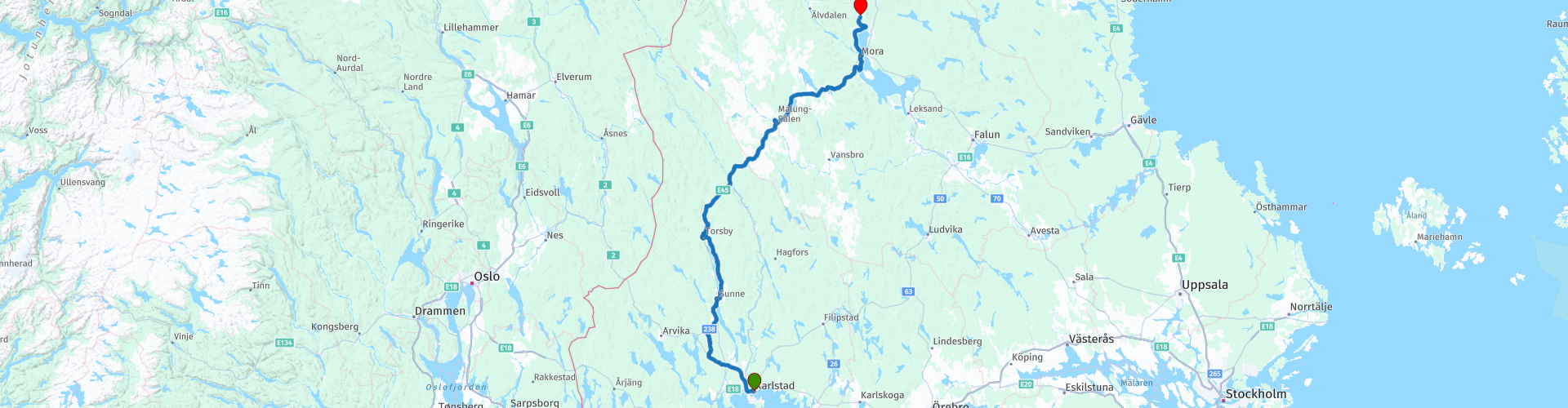
02 Karlstad to Orsa

This route was brought to you by:
RouteXpert Leon Bodegom
Last edit: 04-03-2021
 Route Summary
 This was part 2 of our 2019 tour and introduction to Sweden. There is plenty to see and visit along the way. However, keep in mind the opening times of places to visit. The tourist season is short and in several places the sights were sometimes only opened after Whit Monday. In this part there are several beautiful stops for a visit and even though the number of daylight hours is high in the summer, the days are still short to see everything.
Beautiful roads, curves, lakes, rivers, heather and swamps alternate with forests and green hills. If you want you can drive part of the route on gravel. Watch out for the bears, lynx, wolves and moose that live here. So you have to watch out.
Start: Karlstad, Hotel Clarion Drott
End: Fryksas, Fryksås Hotell
I have awarded this route with 3 *** stars because the landscape is varied, the roads are good and the attractions very good.
 Share this route


Animation

Verdict


Duration
10h 50m

Mode of travel
Car or motorcycle

Distance
315.73 km

Countries

 RouteXpert Review
 See how to include the places to visit in the planning for this route. If you stop for a visit in the park mentioned below, you will probably have the coffee there and you can then go straight to the lunch stop. If you are not visiting the park, it is best to pause at one of the indicated coffee stops. Also in Sweden not everything is open every day, certainly not before or after the season. That is why it is sometimes better to drive up and see if it is open before you continue for 100 Km and then arrive at that address which is then closed. Have myself gained the experience that it can sometimes take a very long time for the next stop.
Depending on your chosen route, you will reach the town of Rottneros after 70-80 Km. The Rottneros Park is a unique sculpture park with a combination of formal park areas, natural parkland vistas and creative horticultural design. For about € 12 pp you have access to the park.
Just past the park there is the Stamfrande monument to the right of the road. This is a monument related to the immigration and emigration between Sweden and the United States. From here you have a wide view over the Golf Course over the Mellen Fryken lake. Here is also an opportunity for a cup of coffee or a snack.
After a smooth part of the route of 50 km you are in front of the Thorsby car and motorcycle museum. Small-scale but certainly worth a visit. Open every day from June to September.
At the marked points of the route you can always buy something to eat or drink. But otherwise the country is sparsely populated so you will not find many other stops on the route.
After Thorsby we pass the town of Malung, the center of the leather industry. Here is also the workshop of Jofama motorcycle clothing. If you want to buy something made of leather, you can certainly find it in this place.
Halfway the route from Thorsby to Malung is a restaurant to the left of the road 'Dutch mountain' with an old-fashioned Dutch traffic column at the entrance.
You follow the road E45, it sounds like a highway, but it is absolutely not. Slowly cruising you end up in the town of Mora. This is a fairly large town for the region with plenty of dining options and shopping opportunities. Just outside Mora, the advice is to refuel the engine for the next day. From here it is about 30 Km to the end point in Frykas.
This is a beautifully situated village in the hills with a panoramic view.
But there you can only eat in the hotel and there is no other facility.
For camping enthusiasts, 2 poi's have also been added from campsites in the woods and on the waterfront near Orsa.


 Links
Links  Usage
Usage Want to download this route?
You can download the route for free without MyRoute-app account. To do so, open the route and click 'save as'. Want to edit this route?
No problem, start by opening the route. Follow the tutorial and create your personal MyRoute-app account. After registration, your trial starts automatically.  Disclaimer
Use of this GPS route is at your own expense and risk. The route has been carefully composed and checked by a MyRoute-app accredited RouteXpert for use on TomTom, Garmin and MyRoute-app Navigation.
Changes may nevertheless have occurred due to changed circumstances, road diversions or seasonal closures. We therefore recommend checking each route before use.
Preferably use the route track in your navigation system. More information about the use of MyRoute-app can be found on the website under 'Community' or 'Academy'.