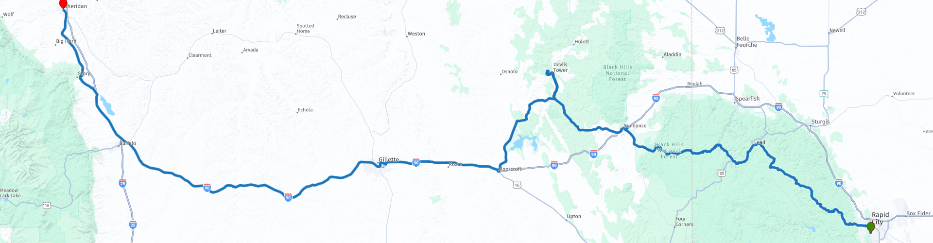
D06 Rapid City Sheridan

This route was brought to you by:
RouteXpert Hans van de Ven (Mr.MRA)
Last edit: 21-12-2019
 Route Summary
 The roads are good and the views are wide and beautiful, a long day with many stops to take pictures and visit some special places such as Devils Tower.
Starting point: Quality Inn Rapid City
End point: BEST WESTERN Sheridan Center
The route has been made the same for TomTom, Garmin and MyRoute-app Navigation users.
Thanks to Richard & Lisa for the information!
 Share this route


Animation

Verdict


Duration
6h 10m

Mode of travel
Car or motorcycle

Distance
471.48 km

Countries

 RouteXpert Review
 This (long) route starts in the Black Hills, so leave on time! We stop in Lead at the Sanford Lab Homestake Visitor Center, where you can view historical photos, videos and a 3D model and tell the fascinating stories about the Sanford Underground Research Facility (Sanford Lab), the city of Lead and the history of Homestake . See the 1,000 foot deep Open Cut, an iconic monument in the Black Hills, and see the many types of rock that have created this unique landscape. Admission is free.
We drive further towards Spearfish Falls, Spearfish Falls is slightly off the beaten track, but well worth the walk. It is located in the heart of Spearfish Canyon near the Savoy area. The path to the waterfall starts on the north side of the restaurant Latchstring Inn and leads you to the bottom of the gorge where you go to the roaring water of Spearfish Falls. Make sure you wear good shoes, because the pad can sometimes be slippery. For those who want to skip the walk, there is a viewing platform on the south side of the restaurant. Spearfish Falls is approximately 20 km south of the northern entrance to Spearfish Canyon.
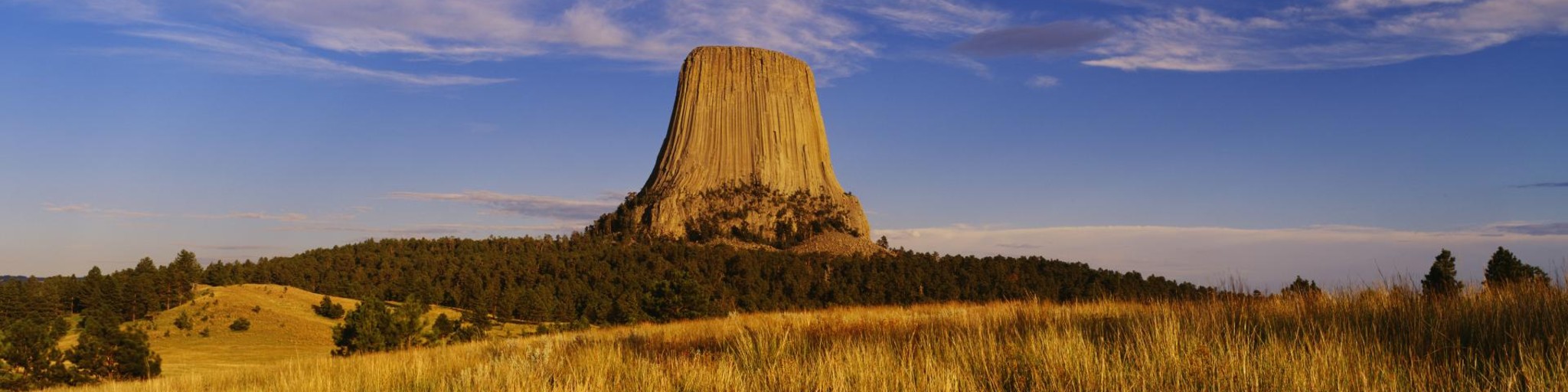
We drive on and pass by one of the places where the movie Dances with Wolves was shot, stop for some photos! Then we arrive in Sundance, where we stop to refuel and have something to eat and drink. After the stop we go to the Devil's Tower National Monument, where the heart of an old volcano rises from an almost flat environment up to 264 meters. Devils Tower was the first national monument in the United States, erected on 24 September 1906 by President Theodore Roosevelt. After the visit we head towards Moorcroft where we enter Interstate 90 (I-90). We leave the I-90 at Gilette again to refuel and have something to eat. After this short stop we look for the I-90 again to leave it at Buffalo.
You now have the opportunity to visit Fetterman Monument & Fort Phil Kearny. The Fetterman Battlefield is the monument of the worst defeat of the American army by Plains Indian groups. Capt. William J. Fetterman, sent out to help a wagon convoy, was lured by Crazy Horse and other Lakota Sioux and Cheyenne warriors over the Lodge Trail Ridge just north of Fort Phil Kearny.
Fort Phil Kearny was an outpost of the US Army that existed at the end of 1860 in present-day northeastern Wyoming along the Bozeman Trail. Construction began Friday, July 13, 1866 by companies A, C, E and H of the 2nd Battalion, 18th Infantry, under the direction of the Regimental Commander and commander of the mountain district Colonel Henry B. Carrington. The position was named after Major General Philip Kearny, a popular figure in the American Civil War. The fort must be distinguished from Fort Kearny in Nebraska, which was named after Kearny's uncle Stephen W. Kearny. Today, the fort and nearby Fetterman and Wagon Box combat sites are maintained by the state of Wyoming as the historic site of Fort Phil Kearny State.
After a possible visit to these 2 historic places it continues to the end point in Sheridan, where we first have to refuel before we reach the hotel.
In this 4-star route you drive on beautiful good roads, a stop at Devils Tower and Spearfish Falls you should definitely do.
History:
Sheridan was designed in 1882. John D. Loucks is said to draw the town on the back of a piece of wrapping paper. The city was named after one of Louck's generals; Philip Sheridan. He led the Union troops during the American Civil War. Sheridan was officially seen as a city from 1884. With the arrival of a railroad and the opening of many coal mines, the newly baked city grew rapidly. At the beginning of the twentieth century, the wooden structures of the buildings in the city were replaced by stone and cement. Most of these buildings are still standing and are mainly in the Main Street Historic District.
In the first century that Sheridan existed, livestock farming, coal mines, railways and sugar beet cultivation were the main occupation of the inhabitants. But just like with the other cities, that has changed. The city has undergone major modernization and the healthcare, education and finance sectors have grown.


 Links
Links  Usage
Usage Want to download this route?
You can download the route for free without MyRoute-app account. To do so, open the route and click 'save as'. Want to edit this route?
No problem, start by opening the route. Follow the tutorial and create your personal MyRoute-app account. After registration, your trial starts automatically.  Disclaimer
Use of this GPS route is at your own expense and risk. The route has been carefully composed and checked by a MyRoute-app accredited RouteXpert for use on TomTom, Garmin and MyRoute-app Navigation.
Changes may nevertheless have occurred due to changed circumstances, road diversions or seasonal closures. We therefore recommend checking each route before use.
Preferably use the route track in your navigation system. More information about the use of MyRoute-app can be found on the website under 'Community' or 'Academy'.