Day 12 TCH Winnipeg to Kenora

This route was brought to you by:
RouteXpert René Plücken (MRA Master)
Last edit: 12-02-2021
 Route Summary
 This is part 12 that runs from Winnipeg to Kenora.
The Trans Canada Highway passes through all the southern provinces of the country. The route can be driven in different ways. There are namely in various alternative routes that also belong to the TCH. The total distance is around 8,000 km. We not only drive the TCH, but will take the rural roads as much as possible, because only highway driving is too boring and Canada has many beautiful roads through its beautiful landscape.
You drive through all provinces and through very varied and scenic landscapes, from the Rockies in the West, the Central Prairies to the Eastern Maritimes and the Northern Forest.
The riding season is generally April through October with longer seasons on the west coast and southern Ontario.
Provide good all season clothing or bring rain gear, depending on the province and the season the weather can change and you may be surprised by a rain or even a snow or hail shower, so be prepared.
In Canada the metric system is used, so speeds are indicated in Km / h. A helmet requirement (DOT approved) applies throughout Canada.
You will see many wildlife throughout Canada. your similar animals from province to province, such as deer, buffalos, moose, caribou, wolves, pumas, bears, mountain goats, sheep, lynx, coyotes, foxes, raccoons, badgers, various rodents and all kinds of birds.
Even if it is very tempting to stop for a photo, don't do it, it can be very dangerous.
 Share this route


Animation

Verdict


Duration
4h 54m

Mode of travel
Car or motorcycle

Distance
298.94 km

Countries

 RouteXpert Review
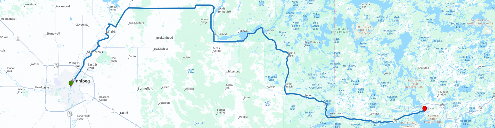
 Those who want to drive the TCH can follow the signs “1 East” from the center and then follow the “MB-1” to Kenora.
From the center “Main Street” we head north on the Henderson Highway (42) follow the course of the Red River of the North to leave Winnipeg, at RP3 we cross this river via the Selkirk Lift Bridge. This steel bridge was built in 1935 by the engineering firm Macaw & MacDonald to replace an existing ferry. The center section rises through a system of pulleys and counterweights to allow the ships to pass under the bridge.
We drive north to Libau via Provincial Trunk Highway 59. At Libau, we turn right onto Provincial Road 317 to Lac du Bonnet, then head south again through Provincial Trunk Highway 11, following the course of the Winnipeg River. After 20 kilometers we turn left and take the Provincial Road 307.
We now drive the Manitoba area in what is also known as the land of 100,000 lakes. The road leads past many lakes, so you regularly have a nice view of the lakes. A number of lakes are marked with a route point and POI. Hiking enthusiasts can stop at one of the many trails along the route, which are well signposted.
There are not many options along the way to stop for food and drinks, so get a package with some sandwiches and water. RP8 has two small restaurants, a supermarket and a gas station.
At RP10 you can stop briefly at the Bannock Point Petroforms, these are stones laid out on the rock in the form of turtles, snakes, geometric designs and a Thunderbird. They are believed to have been created centuries ago by First Nations people for their value in teaching and healing ceremonies.
We continue the drive and at the end of Provincial Road 307 we turn left and continue on Provincial Trunk 44 Highway until we turn left at Whitshell and turn onto TCH for the last leg of the drive to Kenora.
At RP20 we enter Ontario, here is another Manitoba Welcome Sign, nice to stop for a photo. A little further at RP21 you can visit the Manitoba Visitors Center for a souvenir. The landscape in Ontario is slightly more hilly with more trees, but also here many lakes and rivers, this together makes for beautiful panoramas.
Just before the end of this ride you can stop for a photo at "Husky the Muskie" (RP22), a large replica of a Muskie fish and a nationally known symbol for the city of Kenora. The statue was built in 1967 and later rebuilt in its original state in 1995. The fish is 40 feet long, weighs 2.5 tons, and is located in McLeod Park, proudly on display at the northernmost end of Lake of the Woods.
This route is 300 kilometers long and worth 3 *** Stars because of the beautiful nature, hills, lakes and green plains, unfortunately there are not many sights along the way where you can stop.


 Links
Links  Usage
Usage Want to download this route?
You can download the route for free without MyRoute-app account. To do so, open the route and click 'save as'. Want to edit this route?
No problem, start by opening the route. Follow the tutorial and create your personal MyRoute-app account. After registration, your trial starts automatically.  Disclaimer
Use of this GPS route is at your own expense and risk. The route has been carefully composed and checked by a MyRoute-app accredited RouteXpert for use on TomTom, Garmin and MyRoute-app Navigation.
Changes may nevertheless have occurred due to changed circumstances, road diversions or seasonal closures. We therefore recommend checking each route before use.
Preferably use the route track in your navigation system. More information about the use of MyRoute-app can be found on the website under 'Community' or 'Academy'.