Day 14 TCH Ignace to Thunder Bay

This route was brought to you by:
RouteXpert René Plücken (MRA Master)
Last edit: 07-11-2025
 Route Summary
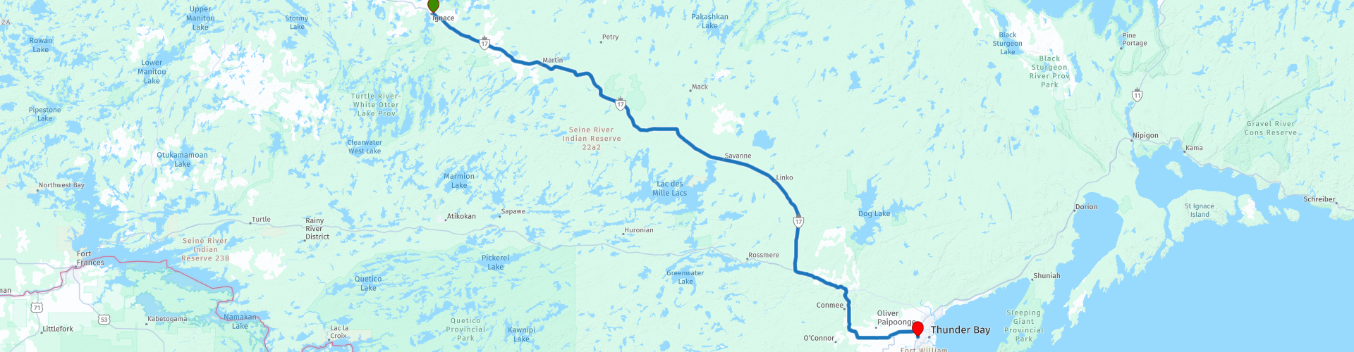
 This is section 14 which runs from Ignace to Thunder Bay.
The Trans-Canada Highway passes through all of the country's southern provinces. The route can be driven in various ways, as there are several alternative routes that also belong to the Trans-Canada Highway. The total distance is around 8,000 km. We won't be driving solely the Trans-Canada Highway, but will be taking as much of the country's back roads as possible, as highway driving alone is too boring, and Canada boasts many beautiful roads through its stunning landscape.
You'll drive through all the provinces and through very diverse and picturesque landscapes, from the Rockies in the west, the Central Prairies to the eastern Maritimes and the northern forest.
The riding season is generally from April to October with longer seasons on the west coast and southern Ontario.
Make sure you have good all-season clothing or bring rain gear. Depending on the province and the season, the weather can change suddenly and you might be surprised by a rain shower, or even a snow or hail shower, so be prepared.
In Canada, the metric system is used, so speeds are indicated in km/h. Helmets are mandatory throughout Canada (DOT approved).
Throughout Canada, you'll see plenty of wildlife. Similar animals vary from province to province, including deer, buffalo, moose, caribou, wolves, cougars, bears, mountain goats, sheep, lynx, coyotes, foxes, raccoons, badgers, various rodents, and a variety of birds.
Even though it is very tempting to stop for a photo, don't do it, it can be very dangerous.
Besides the beautiful waterfall, there are no other sights along the route that warrant a longer stop. Nevertheless, this drive is enjoyable thanks to the scenic Trans-Canada Highway, which passes through stunning and diverse scenery. That's why I'm giving this route 3*** stars.
 Share this route


Animation

Verdict


Duration
6h 5m

Mode of travel
Car or motorcycle

Distance
245.72 km

Countries

 RouteXpert Review
 The morning in Ignace is quiet, surrounded by forests that stretch to the horizon. Today we drive to Thunder Bay, a stretch of Highway 17, part of the legendary Trans Canada Highway. Not a spectacular route, but a drive full of panoramas that reveal the heart of Canada: pristine forests, sparkling lakes, and rock faces that stand like sentinels along the road.
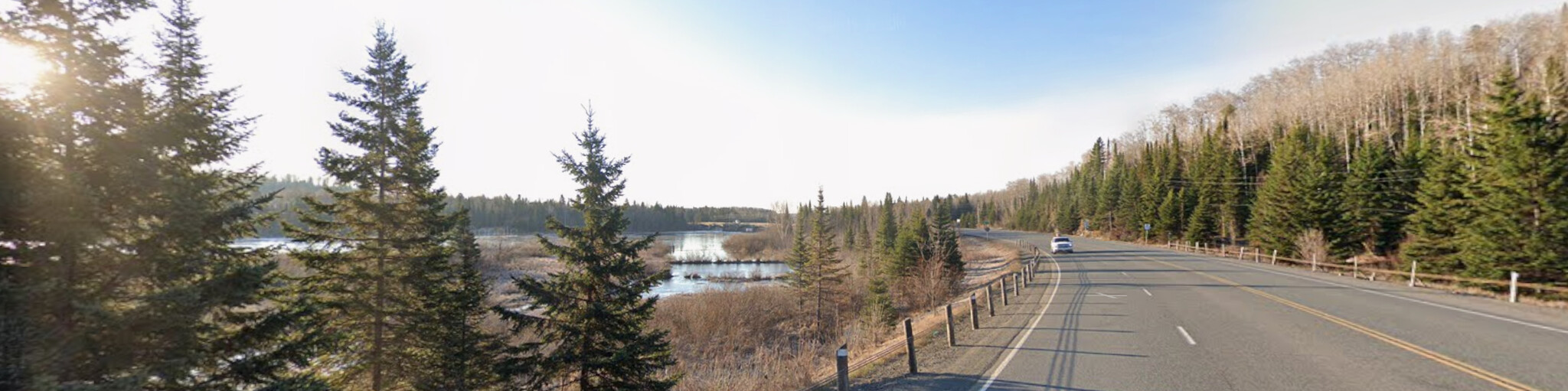
The asphalt winds through a landscape that never bores. Along the way, there are a few spots worth a quick stop, not for the major sights, but for moments you want to capture.
After about 2 kilometers, we briefly leave the highway and take a dirt road to a wooden lookout tower. From here, a tranquil view unfolds: a sea of green, punctuated by glistening expanses of water.
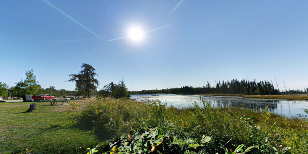
Further along, there's a rest area overlooking the Lodge Lake. It's a perfect spot to pause, take a photo, and breathe in the tranquility of Ontario.
We'll stop briefly at the Central/Eastern Standard Time Zone Marker. Here, you're literally standing on a degree of longitude, a symbolic boundary where time shifts by one hour. A photo at the marker is a must.
We cross the Kaministiquia River, called "Gaa, ministigweyaa" by the Ojibwe, "river of islands," which flows into Lake Superior. Its delta divides into three branches, once designated on French maps as les trois rivières. Today, it is not only a natural wonder but also a source of energy: dams and hydroelectric power plants supply Ontario with electricity.
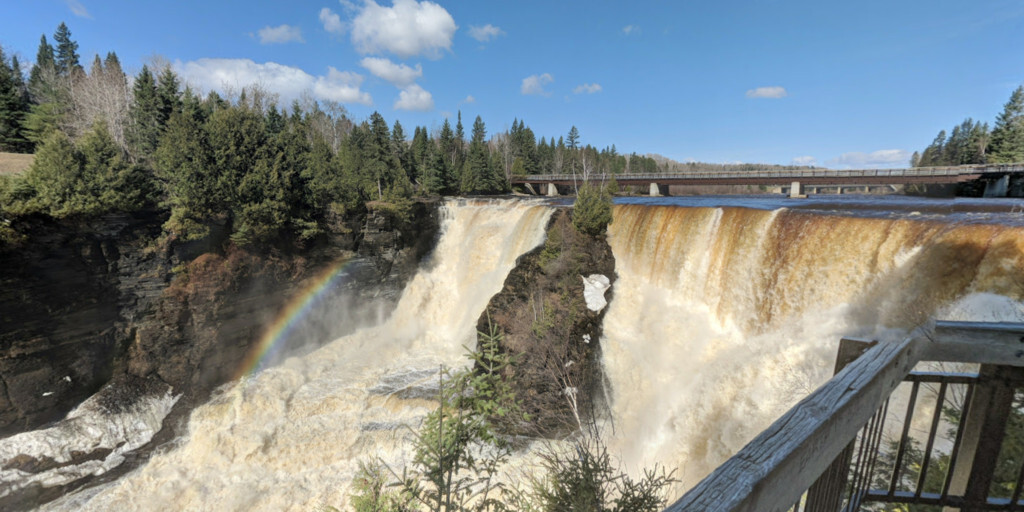
The highlight of the day awaits at Kakabeka Falls. This 40-meter-high waterfall plunges into a gorge carved by meltwater from the Precambrian Shield. It's not without reason that it's nicknamed the "Niagara of the North." The thundering water, the rising mist, and the boardwalks make this a place you won't want to miss.
After this final stop, we continue to Thunder Bay, situated on the mighty Lake Superior, the largest freshwater lake in the world. The city surprises with nature parks like Sleeping Giant Provincial Park, and culture: in 2003, Thunder Bay was named Canada's Cultural Capital. Fort William Historical Park is the main attraction, a reconstructed 1815 trading post that takes you back to the fur trade era.
No long list of sights today, but a ride that touches your soul through the beauty of simplicity. My rating: ★★★, Three stars for a leg that takes you through the quiet, rugged heart of Ontario, with Kakabeka Falls as its crown jewel. Tomorrow, Lake Superior awaits, and new stories.
 Links
Links  Usage
Usage Want to download this route?
You can download the route for free without MyRoute-app account. To do so, open the route and click 'save as'. Want to edit this route?
No problem, start by opening the route. Follow the tutorial and create your personal MyRoute-app account. After registration, your trial starts automatically.  Disclaimer
Use of this GPS route is at your own expense and risk. The route has been carefully composed and checked by a MyRoute-app accredited RouteXpert for use on TomTom, Garmin and MyRoute-app Navigation.
Changes may nevertheless have occurred due to changed circumstances, road diversions or seasonal closures. We therefore recommend checking each route before use.
Preferably use the route track in your navigation system. More information about the use of MyRoute-app can be found on the website under 'Community' or 'Academy'.