09 Rondrit Sachsische Schweiz Westelijke zijde

This route was brought to you by:
RouteXpert Leonor Orban - Sr. RouteXpert
Last edit: 02-08-2025
 Route Summary
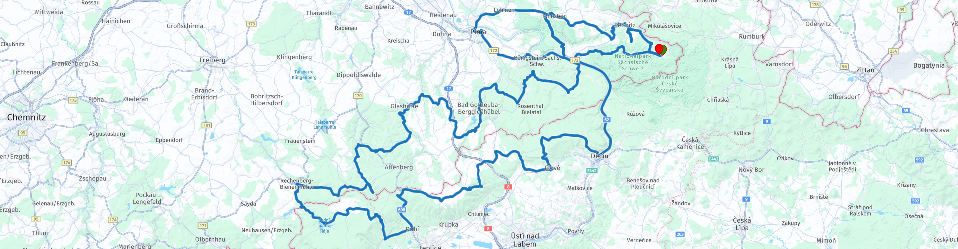
 It is a tour through the Western part of the Sachsische Schweiz. The first part of the day you mainly drive to the West on the German side. In the afternoon you will slowly drive back to Hinterhermsdorf via the Czech Republic.
Along the way you come across a number of sights such as viewpoints, castles and a bobsleigh track. With driving the route alone you can fill all day. That is why I advise you, if you also want to visit a place of interest, to choose 1 or 2 places, depending on your interest. You can also complete the route without coming back late at night to the hotel.
The route has been made the same for Garmin, TomTom and MyRoute-app Navigation.
 Share this route


Animation

Verdict


Duration
9h 24m

Mode of travel
Car or motorcycle

Distance
285.71 km

Countries


 RouteXpert Review
 This route gets 4 stars from me, because you drive along beautiful rock formations, through forest and over hills. It is a wonderful day of touring with varied sights along the way that you can choose from (both cultural, sporting and beautiful viewpoints). The route eventually scores somewhat lower, because the road surface is not always good, certainly on the Czech side. You can regularly (status 2018) come across roads where the asphalt is damaged.
If you have spent the night at Gasthof zur Hoffnung, you will leave from Hinterhemsdorf in the direction of the West to Sebnitz. This is a small town known for the silk artificial flowers that are produced here. Nowadays, salmon is swimming in the river of the same name, which flows through the city.
Because there is plenty to see along the way, today we only drive briefly through this town to continue the route to the first attraction along the route: Schloss Hohnstein. This castle dates from the year 1353 and towers high above the town. In the center you can park your car and from there walk past some beautiful wooden houses to visit the castle. Here you will find two museums; one about the history of the castle and the city. The other about the salmon in the region. You can also climb a lookout tower here to take in the surroundings well. Check the castle's website for opening times and admission prices.
After this cultural interruption you can "get to work again". Immediately after leaving town of Hohnstein you will drive over a number of delightful hairpin bends, after which you will eventually turn onto the road towards the Lilienstein mountain.
On your way to this mountain you first pass the "Ziegenrücken" viewing point. This stop along the S163 offers a view of the Elbe river and valley with the village of Rathen and the famous Bastei rock formation. I didn't stop here myself. If you stop here for a photo and my information is incorrect, I would love to hear from you.
After this photo stop you continue to Waltersdorf. If you enjoy walking, you can turn right in the village and follow the signs to a parking lot from where you can walk further to the Lilienstein mountain. Keep in mind that this is a walk where you can fill a (large) part of the day with. Definitely worth it because of the beautiful view and the rock formations along the way. Lilienstein is one of the most famous rock formations in the Sachsische Schweiz and is therefore a symbol for this area. It is a table mountain located on the right bank of the Elbe. From the parking lot there are several easy walks to and on the mountain, with a number of special viewpoints.
If you continue the route, you will cross the Elbe river at Bad Schandau and enjoy more than 45 minutes of fine winding roads through the nature reserve, after which you will eventually arrive in Bad Gottleuba-Berggießhübel. Here are two restaurants where you can take a break. You can choose delicious sweet dishes at Konditorei Schönbach or hearty dishes at Gasthof Hillig.
After this break you continue driving towards the West. Before you head south to enter the Czech Republic, you will come across 3 more sights.
First you see Schloss Kuckuckstein. This castle cannot be visited, but it towers prominently over the village. It is believed that construction of this castle started around 930. The castle was built as a border fortress, which also explains why it was eventually named "Cuckoo". This bird is regularly seen on coats of arms and is a symbol of vigilance. If someone has been able to find a nice photo spot, I would like to receive the RP so that I can add it to the route.
Secondly you pass the ENSO egg channel Altenberg. This ice rink is used for (international) bobsleigh races. You can look around here and - if you dare - ride a bobsled, up to a maximum of 140 km / h.
Finally you will arrive in Rechenberg. Here you will find a castle ruin on the right side of the route with the local brewery hidden behind it. This is one of the oldest private breweries in the Sachsen region, and offers the opportunity to take a look. In the brewery museum you naturally also have the option to participate in a beer tasting, with or without a hearty meal (Grillhaxe mit Sauerkraut). Please contact us in advance to check whether the museum is open.
After Rechenberg you finally finally go down to the South and cross the border at Český Jiřetín. Then you drive back to the East via the Czech Republic. You will soon pass the Fláje dam. You can park here to take a photo of this 56 meter high dam. There are also limited options for visiting the inside of the dam. For more information you can visit the visitor center near the parking lot.
Further on in this area you will come across a number of modest ski slopes. Modest, because the mountains barely exceed 1000 meters (eg Bradáčov, Liščí vrch, Pramenáč and Rudný vrch). These areas are therefore mainly visited by families from the area. Also keep in mind that in this area the quality of the roads can be disappointing, so your average speed on the engine will also go down.
On your way to the last ski area (Ski Areal Telnice) you will pass the Fürstenauer nature reserve (RP25) in Germany. This road section still contains memories of the cold war. Along the way you will come across signs with the text "pozor statni hranice", or "be careful, state boundary". On the shortest part it is perhaps less than 50 meters to the border with Germany.
Eventually you will arrive in Ski Areal Telnice with the ¨Chata u Vlaku¨ break. You can perch here on the terrace and recover from all the impressions.
The last part of the route has arrived. This part is especially enjoy driving. Along the way you drive over winding steering roads through the nature reserve of northern Bohemia. After a while you arrive in Děčín, with a view of the castle of the city and the Pastýřská stěna ("Shepherd's Wall"), one of the Elbe sandstone rock formations.
Here you continue the route along the Elbe river, back to the North and Germany to the end point Gasthof zur Hoffnung. Along the way you have the option to fill up your gas tank before you end the route.


 Links
Links  Usage
Usage Want to download this route?
You can download the route for free without MyRoute-app account. To do so, open the route and click 'save as'. Want to edit this route?
No problem, start by opening the route. Follow the tutorial and create your personal MyRoute-app account. After registration, your trial starts automatically.  Disclaimer
Use of this GPS route is at your own expense and risk. The route has been carefully composed and checked by a MyRoute-app accredited RouteXpert for use on TomTom, Garmin and MyRoute-app Navigation.
Changes may nevertheless have occurred due to changed circumstances, road diversions or seasonal closures. We therefore recommend checking each route before use.
Preferably use the route track in your navigation system. More information about the use of MyRoute-app can be found on the website under 'Community' or 'Academy'.