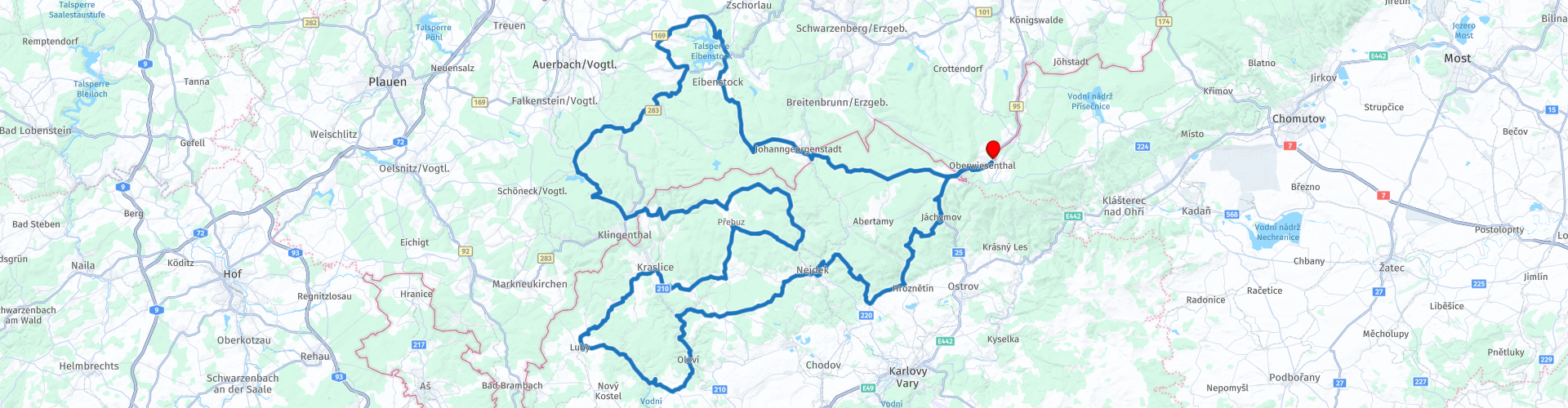
11 Rondrit West Bohemen vanuit Oberwiesenthal

Deze route is gemaakt door:
RouteXpert Leonor Orban - Sr. RouteXpert
Laatst gewijzigd: 17-06-2020
 Route Samenvatting
 Dit is vooral een rondrit om te genieten van het motorrijden. Onderweg heb ik destijds slechts een paar keer gestopt voor foto’s. Desalniettemin heb ik een aantal bezienswaardigheden opgenomen, waar je kunt stoppen om rond te kijken indien je daar belangstelling voor hebt. Denk hierbij aan een oude zilver- en uraniummijn, stuwmeren, restanten uit WWII en kastelen.
Wederom geldt hier als waarschuwing dat de wegen in Tsjechië niet altijd van even goede kwaliteit zijn. Hou er rekening mee tijdens het rijden. Zeker de smallere weggetjes in de bossen kunnen soms op verrassende plekken gaten in het wegdek hebben.
De route is gelijkgemaakt voor Garmin, TomTom en MyRoute-app Navigation.
 Deel deze route


Animation

Beoordeling


Duur
4h 57m

Transportmodus
Auto of motor

Afstand
241.50 km

Landen


 RouteXpert Review
 De route krijgt van mij 3,5 sterren. Dit komt voornamelijk door het slechte wegdek in Tsjechië. De route zelf is wel degelijk de moeite waard: je wordt door een aantal belangrijke gebieden van het Ertsgebergte geleid, langs interessante bezienswaardigheden. Ook het uitzicht is regelmatig schitterend evenals afwisselend.
Het ertsgebergte staat voornamelijk bekend om de intensieve mijnbouw, die sinds 1100 plaatsvond in de regio. Al snel werd bekend dat het gebied rijk was aan zilver, wat ertoe heeft geleid dat mijnbouw-activiteiten ontstonden in dit gebied. Later bleek het gebergte ook rijk te zijn aan delfstoffen zoals zilver, tin, ijzererts, bruinkool en kobalt. Tijdens deze rondrit zul je een aantal bezienswaardigheden tegenkomen, die herinneren aan de intensieve mijnbouw.
Daarnaast is met name het Tsjechische deel (Karlovy Vary of Karlsbad) ook bekend vanwege de vele natuurlijke heilzame bronnen. Onderweg kom je ook een bekend kuuroord tegen. Hierover later in de review meer.
De route begint bij Hotel Alpina Lodge in Oberwiesenthal. Dit gebied is een van de bekendste wintersportgebieden en kuuroorden uit de regio. Dit komt mede door de goede luchtkwaliteit en de hoogte. Dit gebied herbergt de 2 hoogste bergen in het Erts-gebergte: de Fichtelberg met 1215 meter in het Duitse deel en de Keilberg of Klínovec met 1244 meter in het Tsjechische deel.
Vanuit het dorp rij je naar het Westen. Al vrij snel rij je Tsjechië binnen waar je in Boží Dar kunt tanken voordat je aan de route begint. Dit dorp ligt in een groot veengebied, dat je ook doorkruist voordat je Johanngeorgenstadt (Duitsland) inrijdt. Als je goed om je heen kijkt, dan zul je her en der “hopen” of kleine heuveltjes zien. Deze overblijfselen dateren uit de 16e eeuw en zijn gebruikt voor het zoeken naar tin. Het gebied beslaat ongeveer 250.000m2, wat het een van de grootste mijngebieden voor tin maakt in Oost-Europa (RP3).
Meer geavanceerde methodes voor mijnarbeid zie je in Johanngeorgenstadt. Hier is het ook de moeite waard om wat uitgebreider rond te kijken en meer te weten te komen over de mijnbouw in het ertsgebergte. Dit dorp heeft een bewogen verleden dankzij alle mijnbouw. De eerste tekenen van mijnbouw dateren reeds uit de 15e eeuw, toen bleek dat er grote hoeveelheden zilver in de grond zaten. In 1654 werd het dorp gesticht en intensiveerden de mijnbouwactiviteiten steeds verder. Zo werd de eerste grote schacht uitgegraven, waar zich tegenwoordig het Schaubergwerk Frisch Glück "Glöckl" (RP5) bevindt. Je kunt hier onder begeleiding de tunnels bezoeken. Later in de 17e eeuw werd ook een “Pferdegöpel” gebouwd om de mijn-machines onder paardenkracht aan te kunnen drijven. Deze Pferdegöpel is weer herbouwd en tegenwoordig ook te bezoeken (RP6).
In de 19e eeuw werd ook steeds meer Bismuterts en Uraniumerts gewonnen in de mijnen. Langzaam werd dit de belangrijkste inkomstenbron voor de regio, omdat de zilverprijzen daalden door de opkomst van goud als valuta.
In de 20e eeuw, na de Tweede Wereld-Oorlog, groeide de mijn en het dorp al snel uit tot een gigantische industrie. De toenmalige USSR eiste de mijn op om zo veel mogelijk uranium te kunnen winnen voor de wapenwedloop om een eerste atoombom te kunnen bouwen. Op het hoogtepunt van deze mijnbouwactiviteiten werkten meer dan 70.000 kompels in de mijn (ter referentie: in de jaren daarvoor werkten maximaal 5.000 kompels in de mijnen). Door de snelle groei van de mijnbouw hebben de originele gebouwen in het centrum van Johanngeorgenstadt moeten wijken. Hierdoor vind je hier geen dorpskern meer.
Na het bezoek aan de mijn is het tijd om weer te kunnen genieten van de lucht en ruimte om ons heen. Onderweg kom je langs de Eibenstock dam. Je kunt hier kort stoppen om een foto te maken van de dam (RP7) die voorziet in drinkwater voor ongeveer 600.000 mensen in de omgeving van het stuwmeer. Verder op de route komt de ruimte in beeld: het Duitse ruimtevaartmuseum. Buiten voor de hoofdingang van het terrein zie je een gevechtsvliegtuig staan (RP10). Deze is gevlogen door Sigmund Jähn, de eerste Duitser die in de ruimte heeft gevlogen (uiteraard in een ander luchtvaartuig...).
Afhankelijk van hoeveel tijd je hebt doorgebracht in Johangeorgenstadt, kun je een (lunch-)pauze inlassen bij de tweede stuwdam van vandaag: Talsperre Muldenberg. Deze stuwdam is kleiner dan de Elbenstock, maar biedt desondanks toch drinkwater aan zo’n 100.000 mensen. Vlakbij de stuwdam vind je een restaurant langs de weg (RP11) waar je heerlijk kunt lunchen en ook een wandeling kunt maken naar het stuwmeer om wat foto’s te maken.
Na de pauze verlaat je het Duitse deel van het Ertsgebergte en steek je de grens over naar het Tsjechische deel van het Erts-gebergte: Krušné hory. Hou er rekening mee dat vanaf nu de wegen slechter kunnen zijn.
Onderweg rij je door het moerasgebied van Rolava. Je kunt hier stoppen om een beladen plaats te bezoeken: werkkamp en tinfabriek Sauersack / Rolava (RP12). Ten tijde van WWII werden hier ongeveer 500 Franse en Russische militair gevangenen “vrijwillig” aan het werk gezet in de tinfabriek en –mijn. Naar verwachting zou veel tin uit de grond gehaald kunnen worden, maar binnen een aantal jaren werd duidelijk dat er weinig tin in de grond zat. Na de oorlog is de fabriek en mijn ook gesloten en zijn de machines verplaatst naar andere mijnen in de regio. Als je graag urbex foto's maakt, dan is deze plek uitermate geschikt.
Aan de linkerkant van de weg vind je de overblijfselen van de betonnen fabriek en mijn. Deze zijn vrij te bezichtigen en geven een desolate indruk. Hou er rekening mee dat je goed op moet letten waar je loopt. De grootste mijnschachten zijn met betonnen platen afgedekt, maar her en der zijn kleinere openingen naar kelders en schachten met planten overwoekerd, waardoor je makkelijk ergens in kunt vallen. Het terrein is onbewaakt, waardoor het al die jaren langzamerhand door de natuur weer is ingenomen. Aan de overkant van de weg stonden vroeger de houten barakken van de gevangenen. Hier is tegenwoordig weinig tot niets meer van te zien.
De route leidt je slingerend door Krušné Hory. Sinds 2019 is dit een UNESCO beschermd natuurgebied, waardoor je op je gemak door het natuurgebied kunt rijden. Vergeet niet om af en toe te stoppen en mooie foto’s van de omgeving te maken. Doordat het hier zo rustig is, kom je weinig verkeer tegen.
Richting het einde van de middag draai je weer naar het Oosten en zie je ook een andere kant van de geschiedenis van het natuurgebied: Karlovy Vary. Karlovy Vary (of Carlsbad) staat bekend om de vele spa’s en wellness-mogelijkheden. Reeds in de Middeleeuwen werd de helende kracht van diverse bronnen in deze regio bekend, waardoor onder andere de stad Karlovy Vary is ontstaan, maar ook diverse spagebieden buiten de stad.
Een daarvan is kasteel Lužec (RP21). Dit kasteel is gebouwd in opdracht van Koning Karel IV in de 14e eeuw (tevens de naamgever van de regio en stad Karlovy Vary). Dit kasteel was bedoeld als spa-faciliteit tijdens de jacht-uitjes van de koning. In de eeuwen daarna is het kasteel beroemd geworden doordat Koning Rudolph II hier heeft geprobeerd het levens-elixir te ontwikkelen en in WWII piloten van de Luftwaffe en Herman Goering hier regelmatig hebben overnacht. Tegenwoordig is het kasteel een luxe spa-hotel waar je eventueel kunt pauzeren. Indien je liever ergens anders een tussenstop voor een pauze inlast, dan kun je verder op de route bij restaurant Havlovka (RP23) stoppen. Dit gezellige houten huis net naast de route biedt wat meer lokale charme en een mooi uitzicht op het omliggende natuurgebied.
Na deze pauze is het nog maar 30 – 45 minuten rijden naar het eindpunt. Dit hangt af van hoe snel je rijdt uiteraard, maar ook of je nog even wilt stoppen voor een foto van kasteel Freudenstein / Šlikův. Het kasteel dateert uit 1513 en was gebouwd om de zilvermijnen in de omgeving te kunnen beschermen. Door de jaren heen is het herhaaldelijk neergehaald en weer opgebouwd. In de 20e eeuw is het uiteindelijk in verval geraakt, waardoor alleen de twee torens nog overeind staan. Bijzonder weetje: gek genoeg loopt de weg tussen de twee torens door. Dit komt omdat de lokale overheid vond dat de meest logische route voor de weg dwars over de oude kelders van het kasteel lag. De kelders zijn volgestort met beton en de weg is er overheen gebouwd...
Het laatste stuk van de route kom je weer over een bekende weg: je rijdt terug via Boží Dar waar je even kunt stoppen om te tanken voordat je eindigt bij Hotel Alpina Lodge Oberwiesenthal.


 Links
Links  Gebruik
 Deze route downloaden?
Je kan de route gratis, zonder MyRoute-app account downloaden. Om dit te doen, open de route en klik op 'opslaan als'. Deze route wijzigen?
Geen probleem, open eerst de route. Volg de tutorial en maak je eigen MyRoute-app account aan. Na registratie, start je trial automatisch.  Disclaimer
Gebruik van deze gps-route is voor eigen rekening en risico. De route is met zorg samengesteld en door een MyRoute-app geaccrediteerde RouteXpert gecontroleerd voor gebruik op zowel TomTom, Garmin als MyRoute-app Navigation.
Door gewijzigde omstandigheden, wegomleidingen of seizoensafsluitingen kunnen er toch veranderingen zijn ontstaan. Daarom adviseren wij iedere route voor gebruik te controleren.
Gebruik bij voorkeur de routetrack in je navigatiesysteem. Meer uitleg over het gebruik van MyRoute-app kun je vinden op de website bij ‘Community’ of ‘Webinars’.