Bad Driburg Simply the best

This route was brought to you by:
RouteXpert Dirk-Jan Berman
Last edit: 07-03-2020
 Route Summary
  Share this route


Animation

Verdict


Duration
4h 49m

Mode of travel
Car or motorcycle

Distance
263.02 km

Countries

 RouteXpert Review
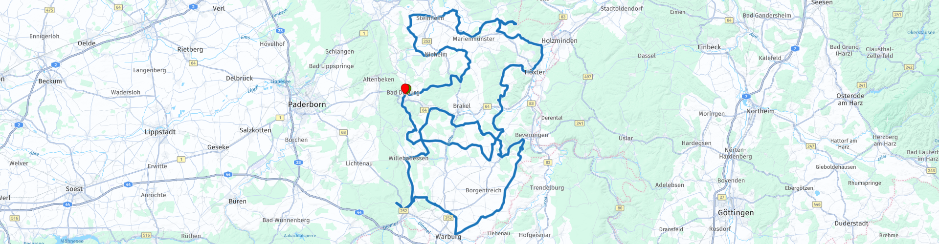
 From Bad Driburg you drive via the Emder Höhe to Bellersen, which is beautiful in the valley. Nearby is the engine venue Gut Externbrock. A little further, the historic city center of Nieheim comes into view. Furthermore, the tour takes you over small roads through the Steinheimer Börde. The silhouette of the former Benedictine monastery Marienmünster can be seen from afar. With many curves, it goes on to the Köterberg, which rises by far over the region with its almost 500 m height. The Tonenburg is definitely worth a next stop. Via Lütmarsen you continue to Bosseborn, one of the highest places in Kreis Höxter. With a lot of hairpin turns you then go to Ottbergen. Also the further course of the route is pure pleasure: on the right a small creek clatters and you get beautiful views over the wide landscape.
The tour continues in the south of Kreis Höxter past the former monasteries in Willebadessen and Hardehausen. The journey continues towards the hanseatic city of Warburg. Whoever strolls through this city and admires the historic half-timbered houses with ornaments, can imagine what significance the hese once had. A little further to the right the volcanic cone Desenberg appears. You can also enjoy the view from the mountain village of Haarbrück: the Sababurg in the Reinhardswald and the porcelain factory Fürstenberg on the Weser can also be seen from here. In the further course of the tour up to Bad Driburg some nice curves followed and another cultural showpiece in the leading role Schloss Gehrden, where it is certainly worth stopping for a while.


 Links
Links  Usage
Usage Want to download this route?
You can download the route for free without MyRoute-app account. To do so, open the route and click 'save as'. Want to edit this route?
No problem, start by opening the route. Follow the tutorial and create your personal MyRoute-app account. After registration, your trial starts automatically.  Disclaimer
Use of this GPS route is at your own expense and risk. The route has been carefully composed and checked by a MyRoute-app accredited RouteXpert for use on TomTom, Garmin and MyRoute-app Navigation.
Changes may nevertheless have occurred due to changed circumstances, road diversions or seasonal closures. We therefore recommend checking each route before use.
Preferably use the route track in your navigation system. More information about the use of MyRoute-app can be found on the website under 'Community' or 'Academy'.